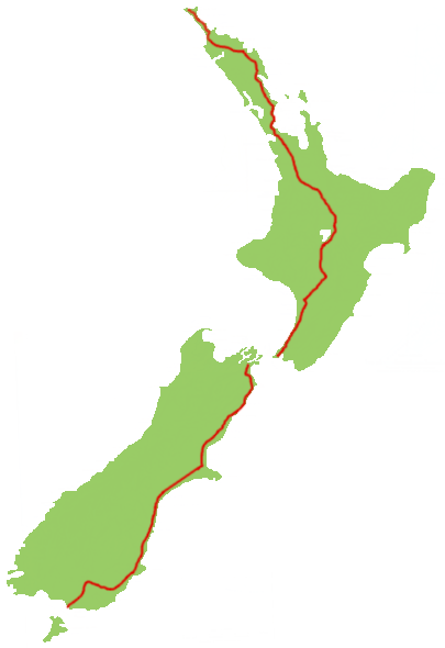
- New Zealand State Highway 1
-
State Highway 1

Route information Maintained by New Zealand Transport Agency Length: 2,047 km (1,272 mi) Tourist
routes:Twin Coast Discovery Highway
Thermal Explorer Highway
Classic New Zealand Wine Trail
Alpine Pacific Triangle
Southern Scenic RouteMajor junctions North end: Cape Reinga South end: Bluff Location Primary
destinations:Whangarei, North Shore, Auckland, Manukau, Hamilton, Taupo, Porirua, Wellington, Picton, Blenheim, Christchurch, Ashburton, Timaru, Oamaru, Dunedin, Gore, Invercargill Highway system New Zealand State Highways
Motorways and Expressways • List • Unused←  SH 99
SH 99SH 2  →
→State Highway 1 is the longest and most significant road in the New Zealand roading network, running the length of both main islands. It appears on road maps as SH 1 and on road signs as a white number 1 on a red shield, but it has the official designations SH 1N in the North Island, SH 1S in the South Island.
SH 1 is 2047 km long, 1106 km in the North Island and 941 km in the South Island. For most of its length it is a two-lane single carriageway, with at-grade intersections and property accesses, in both rural and urban areas. These sections have some passing lanes. There are sections of motorway in the vicinity of Auckland, Wellington, Christchurch and Dunedin.
Contents
Route
North Island (SH 1N)
SH 1 starts at Cape Reinga, at the northern tip of the Aupouri Peninsula. The first stretch, to Waitiki Landing, was finally sealed in April 2010.[1] From Waitiki Landing, SH 1 travels down the central-eastern side of the peninsula to Kaitaia, New Zealand's northernmost town. The highway then takes a south-eastern direction across the North Auckland Peninsula to Kawakawa in the Bay of Islands, before turning south to reach the city of Whangarei, the largest urban area in Northland.
SH 1 then skirts the southern shore of the Whangarei Harbour, meeting the coast briefly at Ruakaka, before turning inland and winding through the Brynderwyn Hills before approaching the upper reaches of the Kaipara Harbour. The highway crosses into the Auckland Region, and passes through Wellsford and Warkworth, again heading for the east coast.
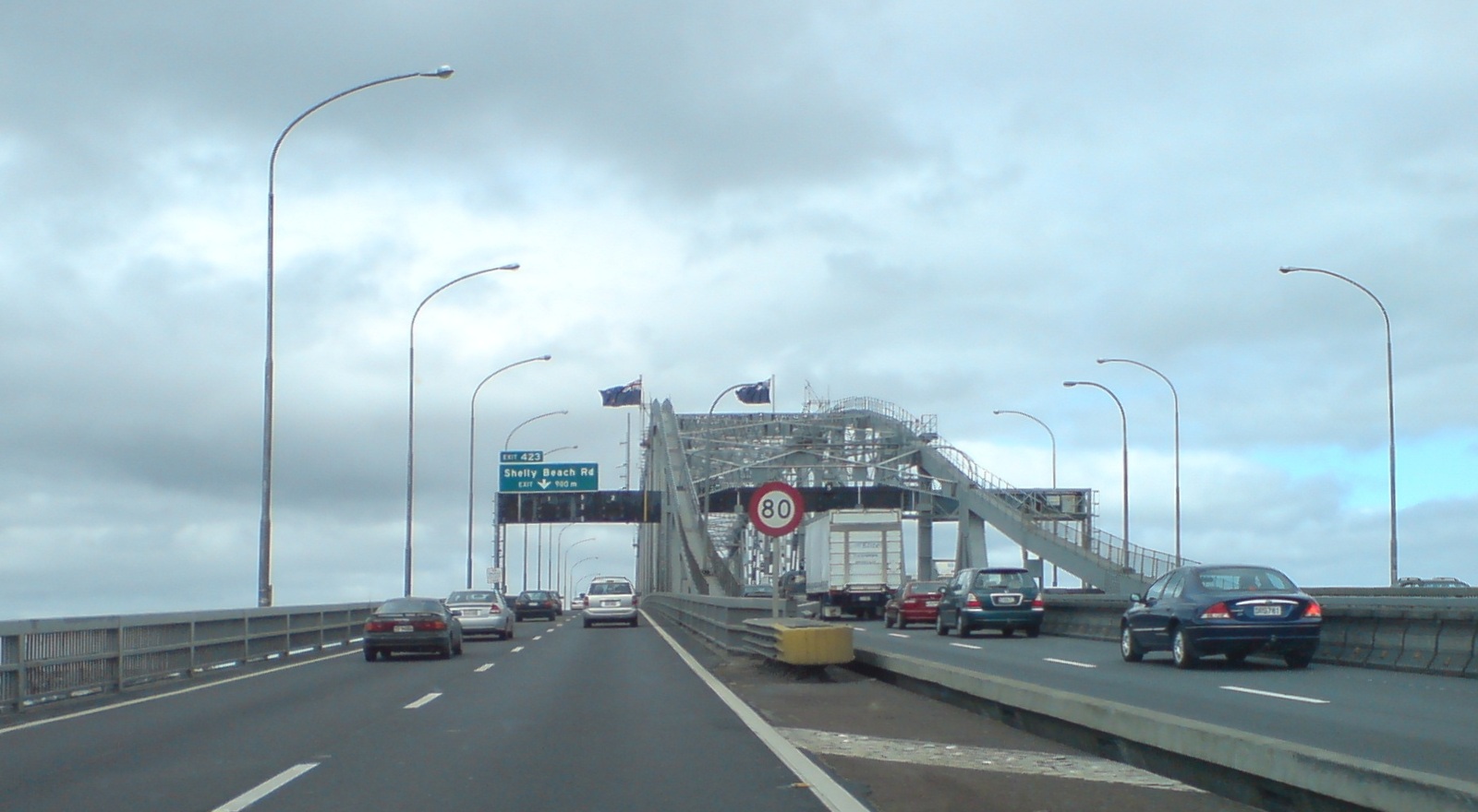
Near Puhoi, on the Hibiscus Coast, SH 1 becomes the Auckland Northern Motorway, the main road north of New Zealand's largest urban area. The first 7 km of the motorway is an automated toll road, with the toll being NZ$2 each way for cars.[2] At Orewa, the motorway becomes toll-free, crossing farmland to North Shore City, the northern of Auckland's four former cities. The road crosses through suburbs to the Waitemata Harbour, which it briefly follows before crossing it by the Auckland Harbour Bridge, New Zealand's second-longest and most widely recognised road bridge. The motorway comes off the bridge into Auckland's city centre, and forms its western boundary as SH 1 proceeds to the Central Motorway Junction.
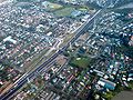
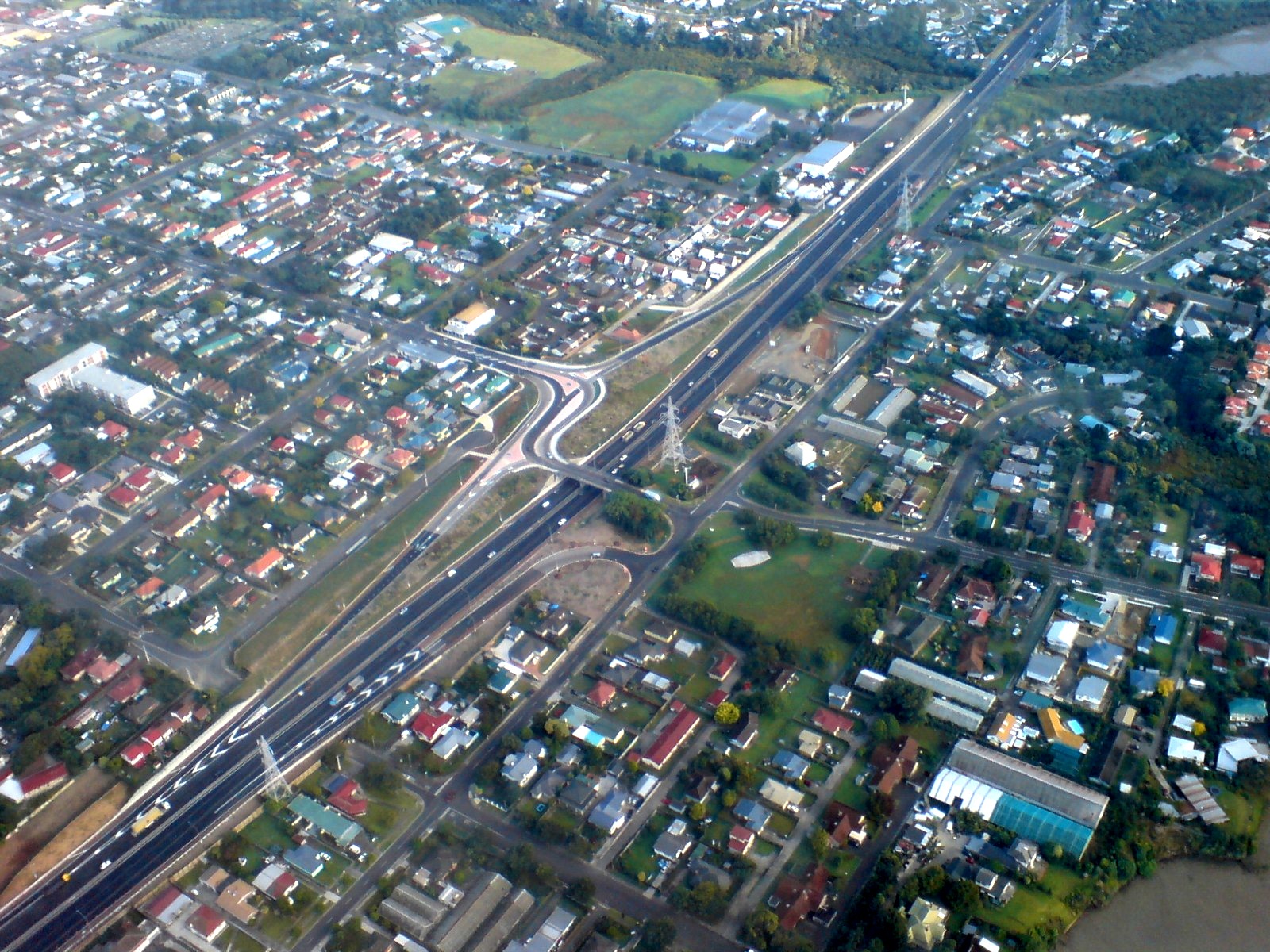
At this junction (also known as Spaghetti Junction), SH 1 becomes the Auckland Southern Motorway, and, after sweeping around the southern end of central Auckland, proceeds in a south-easterly direction. The section from the Central Motorway Junction and the Newmarket Viaduct, 3 to the south, is the country's busiest section of road, with more than 200,000 vehicle movements a day between Khyber Pass Road and Gillies Ave.[3] The motorway continues in a broadly southeast direction through southern Auckland city, through Manukau City and Papakura, to the top of the Bombay Hills, just short of the Auckland/Waikato boundary.
At Bombay, SH 1 becomes the Waikato Expressway, a four-lane dual-carriageway expressway. The expressway takes the highway down the Bombay Hills to Mercer, where SH 1 meets the Waikato River which it follows for the next 130 km. The Waikato Expressway temporarily ends at Longswamp and becomes a three-laned dual carriageway, resuming at Rangiriri and continuing to its current terminus just south of Ohinewai. A $650 million project is underway to upgrade the existing Longswamp to Rangiriri section, and to extend the expressway from Ohinewai to south of Cambridge.
Returning to single carriageway, SH 1 runs through Huntly and Ngaruawahia to Hamilton, New Zealand's fourth-largest city. The highway bypasses the city centre to the west, before crossing to the east side and proceeding south-east out of the city. A small section of expressway exists south of Hamilton, part of the Waikato Expressway.
SH 1 continues through Cambridge, and along the shore of Lake Karapiro, the last of eight artificial lakes on the Waikato River. At Piarere, SH 1 leaves the actual Waikato River, but continues to follow in its general direction. The highway continues to the town of Tirau, where it turns south to pass through Putaruru and Tokoroa and the surrounding pine forest area.
SH 1 meets the Waikato River again at Wairakei, where the highway follows its course into the tourist town of Taupo. The highway meets Lake Taupo, the Waikato's source and the largest lake in New Zealand. Leaving Taupo, SH 1 followes the eastern shore of the lake for 50 km to Turangi, at the southern end of the lake.
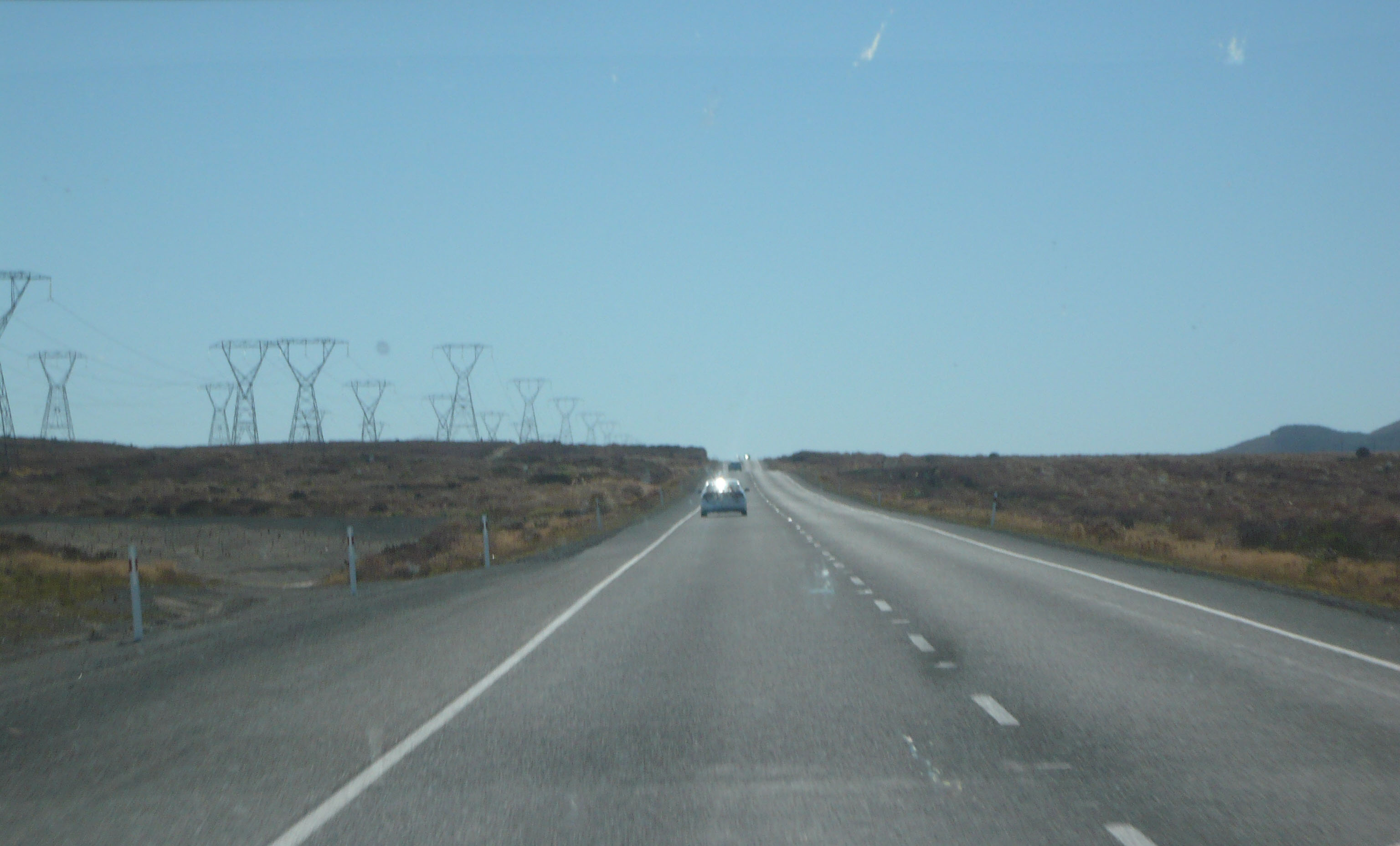
Turning southwards again, SH 1 leaves Turangi and ascends onto the North Island Volcanic Plateau, passing through the fringes of the Tongariro National Park and into the Rangipo Desert, passing the volcanoes of Ruapehu, Ngauruhoe and Tongariro. The road between Rangipo (10 km south of Turangi) and Waiouru is commonly known as the Desert Road, and is frequently closed by snow during winter. At km 794 on the Desert Road, SH 1 is 1,074 metres (3,524 ft) above sea level - the highest point on the New Zealand State Highway network.[4] SH 1 enters the Manawatu-Wanganui Region, and descends through an army training area to the end of the Desert Road at Waiouru.
From Waiouru, the highway follows tributaries of the Rangitikei River through Taihape to Mangaweka, where the highway meets the river. It then followes the western bank of the Rangitikei through Ohingaiti and Hunterville to Bulls. At Bulls, SH 1 turns southeast to cross the river, turning southwest again 5 km down the road at Sanson. SH 1 crosses the Manawatu Plain, passing the city of Palmerston North about 20 km west of it. It passes through Foxton, before reaching the end of the plain at Levin.
From Levin, SH 1 follows the narrowing western coastal plain southwards, and crosses into the Wellington Region 15 km south of Levin. The road passes through Otaki and Waikanae to the main town of the Kapiti Coast, Paraparaumu. The highway is dotted with a large number of satellite towns and villages, and combined with the narrowness of the road, difficult terrain, and the high traffic flow, the stretch of highway between Levin and Paraparaumu is an area of considerable congestion and a high number of accidents.
From Paraparaumu, the road is briefly a four-laned dual carriageway to Mackays Crossing, returning to a two-laned single carriageway and passing through Paekakariki. Between Paekakariki and Pukerua Bay, SH 1 and the North Island Main Trunk rail line travel along a narrow strip of land between the hills and the sea. The Centennial Highway, as it is known, is a narrow two-lane road that was highly accident prone until a centreline wire rope crash barrier was installed. Travelling through Pukerua Bay, the road becomes dual carriageway once more to Plimmerton, narrowing to single carriageway through the northern suburbs of Porirua to Paremata. This section between Mackays Crossing and Porirua is planned to be relieved by the billion-dollar inland Transmission Gully Motorway, due to be constructed within the next 20 years.
At Paremata, SH 1 resumes as dual carriageway along the edge of the Porirua Harbour to Porirua city centre. At Porirua, the highway becomes the Johnsonville-Porirua Motorway, and travels into the northern suburbs of Wellington, New Zealand's capital city. The motorway ends at Johnsonville, and SH 1 descends through the Ngauranga Gorge to the Ngauranga Interchange, on the shore of Wellington Harbour. At the interchange, traffic leaves for the Cook Strait ferries to Picton and the South Island. Ferry services operate frequently to allow vehicular, passenger, and rail traffic to access the South Island. There have been calls for the ferries to be classified as part of the State Highway network, in the belief that this would increase the Government's powers to intervene and keep them running at times of industrial action.
At Ngauranga, SH 1 becomes the Wellington Urban Motorway, skirting the shore of the harbour then passing the city centre to the west. The motorway ends at Te Aro, where a one-way system takes traffic to the Basin Reserve. Northbound traffic uses the recently-opened Wellington Inner City Bypass, while southbound traffic uses Vivian Street. From the Basin Reserve, SH 1 travels through the Mount Victoria Tunnel to Wellington's eastern suburbs and Wellington International Airport. SH 1 ends at a roundabout at the entrance to the airport.
-

SH 1 near Cape Reinga. Sealing of this section was completed in April 2010.
-

SH 1 as the Auckland Northern Motorway, looking north from Forrest Hill, North Shore.
-

SH 1 crossing the Auckland Harbour Bridge.
-

SH 1 through the Central Motorway Junction ("Spaghetti Junction").
-
SH 1, as the Southern Motorway, in northern Manukau City.
-
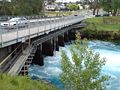
SH 1 bridge across the Waikato River bridge in Taupo. The bridge is fitted with control gates to regulate water flow down the Waikato River.
-

Travelling north on SH 1 through the Rangipo Desert. This section is known as the Desert Road, and is frequently closed by snow in winter.
-

SH 1 as the Wellington Urban Motorway, running beside Wellington Harbour.
South Island (SH 1S)
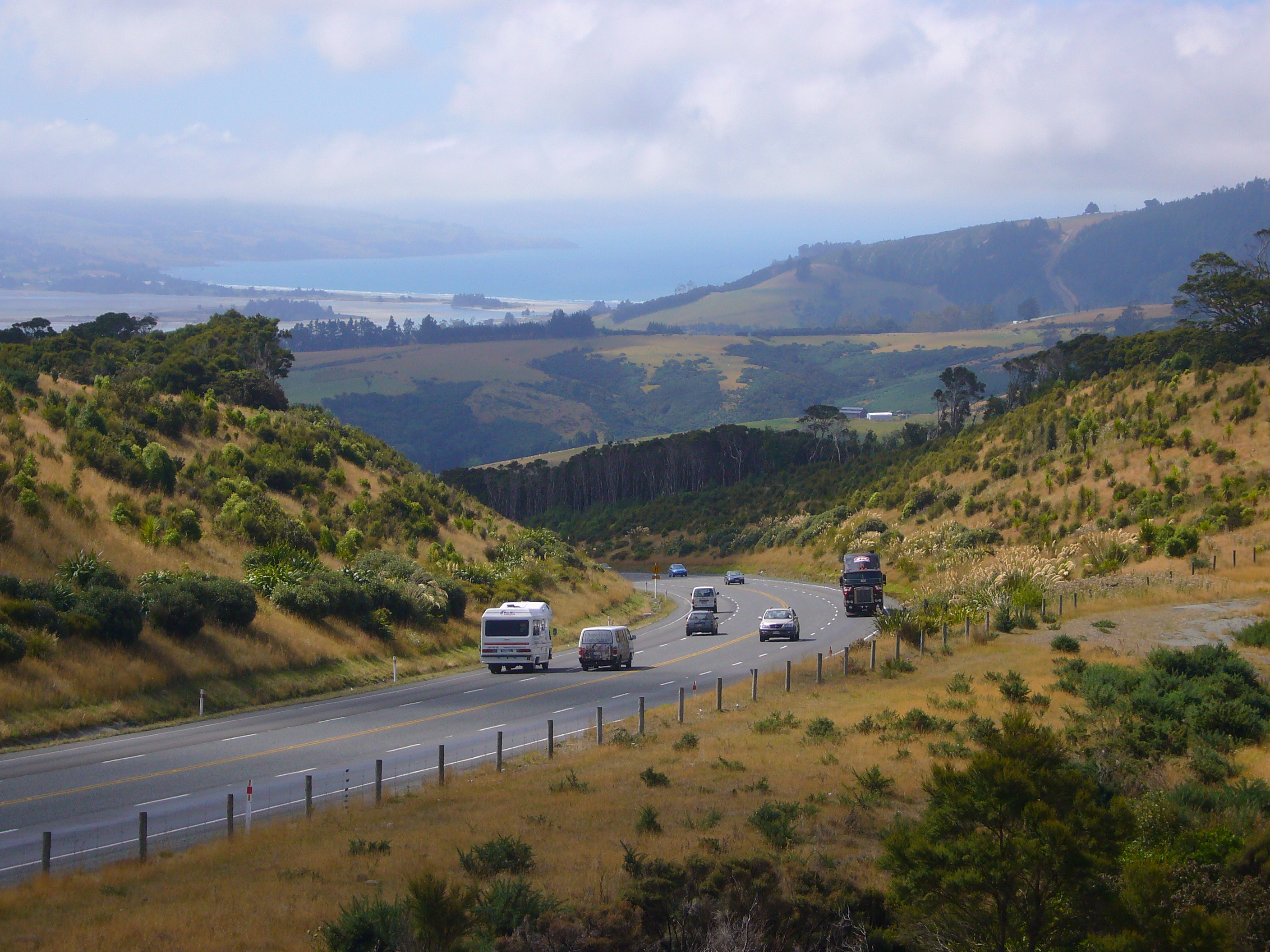
From the Picton ferry terminal, SH 1 is steep, crossing a saddle into the valley of the Tuamarina River. It descends alongside this river and across the Wairau Plain before reaching Blenheim. From Blenheim the road travels briefly through some of Marlborough's famous vineyards, then passes the lower slopes of the steep Kaikoura Ranges where the road has occasional glimpses of the sea to the east over Lake Grassmere. This stretch is one of the most scenic, with the Pacific Ocean on one side and 2500 m peaks on the other. From the small town of Ward the highway heads to the coast and follows it to Kaikoura. After passing Kaikoura, it veers inland, twisting tortuously through the Hundalee Ranges before emerging at the northern end of the Canterbury Plains.
It passes through Amberley before becoming the Christchurch Northern Motorway, bypassing Kaiapoi. The motorway ends just north of Styx, and SH 1 bypasses Christchurch to the north-west through Harewood and Yaldhurst. South of Christchurch, it becomes virtually straight as it crosses the wide fan of the Canterbury plains, crossing the country's longest road bridge at Rakaia before reaching Ashburton, and then veering back towards the coast, which it reaches at Timaru. Between Ashburton and Timaru it crosses Rangitata Island in the Rangitata River.
South of Timaru, the road again passes through gentle hill country, staying close to the coast but largely out of sight of it. The road veers inland briefly, bypassing Waimate as it reaches the plains around the mouth of the Waitaki River, which it crosses to enter Otago. It passes through Oamaru, from where it turns inland briefly, crossing undulating hill country before again reaching the coast at Moeraki. From here the road again hugs the coast along Katiki Beach, remaining closer to the ocean than at any point since Kaikoura. The highway turns inland at Shag Point, passing through Palmerston and Waikouaiti.
South of Waikouaiti the road again becomes steep, rising sharply over the Kilmog hill before dropping down to the coast at Blueskin Bay, then rising again via Dunedin-Waitati Highway (a two- to four-lane single carriageway which used to be designated a motorway) to the northern outskirts of Dunedin. From here it descends a steep, twisting stretch of Pine Hill Road through Pine Hill, before passing the University of Otago and heading through the city centre. For much of its route through Dunedin the highway is split into two separate northbound and southbound roads, part of the city's one-way street system. These roads traverse the city 2-3 blocks southeast of the heart of the CBD. At the southern end of central Dunedin, the highway again becomes a single road, the Caversham By-pass, which rises along the Caversham Valley before again becoming a motorway at the saddle of Lookout Point.
The four-lane motorway (Dunedin Southern Motorway) runs through Dunedin's southern suburbs until the interchange with SH 87 at Mosgiel. SH1 then heads southwest across the Taieri Plains. The area between the Taieri and Waipori Rivers is flood-prone, and the highway crosses this on a major embankment known colloquially as the flood-free highway. SH1 continues through gentle hill country and along the shore of Lake Waihola, then crosses the Tokomairiro Plains into Milton. South of Milton is a major junction with SH 8 at Clarksville Junction. SH 1 continues to cross rolling hill country to reach Balclutha.
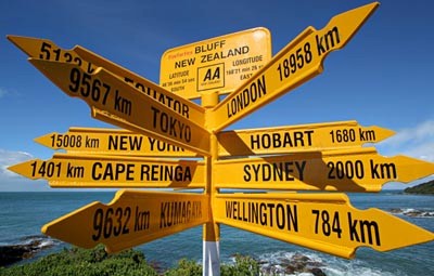
From Balclutha, the highway turns west, veering briefly north as it heads inland to avoid the rough hills of The Catlins. It passes through the small town of Clinton, New Zealand before reaching the major provincial town of Gore. Because of the names of these two towns, this stretch of the highway was christened "The Presidential Highway" during the time of the Clinton-Gore administration in the United States. At Gore the highway crosses the Mataura River; from here the road again turns south to roughly follow the river. The highway passes through Mataura before turning west at Edendale. Over its last stretch the road veers southwest before reaching the city of Invercargill. In central Invercargill it meets the southern end of SH 6 and turns due south, skirting the estuary of the New River and Bluff Harbour. It passes through the small town of Bluff before reaching its terminus at Stirling Point, a kilometre south of Bluff. A commemorative signpost at Stirling Point indicates distances to major world centres and to the start of the highway at Picton.
-

SH 1 passing through the North Canterbury town of Cheviot.
-

Dunedin-Waitati Hwy looking north from near the Pigeon Flat Overbridge. Blueskin Bay is visible in the background
-

In Dunedin, the highway forms a pair multi-lane one-way streets. Cumberland Street, 1km south of the city centre.
-

Signpost at Stirling Point, Bluff.
Road conditions
SH 1 has varied road conditions. For most of its length it is a two-lane single carriageway road with at-grade intersections and access, sealed with chipseal in rural areas or asphalt in urban and high-traffic areas. The highway has frequent passing lanes on these sections, to allow traffic to pass other vehicles safely.
Parts of the road are steep by international standards. Most steep sections having a combination of passing lanes (uphill), and crawler lanes or stopping bays (downhill) to allow heavy and slow vehicles to pull out of the way to let other vehicles pass.
NZTA announced in September 2010 that is was replacing the last three fords on SH 1S. The shingle fan fords are near Kaikoura, and while generally being dry, on about 28 days a year state highway traffic has to detour around them due to high water levels on old single-lane bridges, leading to delays on a major freight route. With the detour bridges reaching the end of their lifespan, NZTA is replacing the fords with culverts.[5]
Route changes
Since Transit New Zealand took control of State Highways in 1989, SH 1's route has changed in some places.
Construction of motorways has diverted the route in many places. A large section of SH 1N via Orewa, Dairy Flat and central Albany was bypassed between Silverdale and Albany in 1999 and 2009 by extensions of the Auckland Northern Motorway. The former route was re-designated SH 17. The extension of the Dunedin Southern Motorway has also seen changes in the highway, notably to bypass the town of Fairfield.
In Hamilton, SH 1N originally ran through the city centre rather than via Frankton. The original route was via Te Rapa Road, Ulster Street, Victoria Street, Bridge Street and Cobham Drive, which is now Hamilton Urban Route 4. The current highway was diverted via Avalon Drive, Greenwood Street, Kahikatea Drive and Normandy Avenue. Continued improvements have meant SH 1N now bypasses a number of small towns in the northern Waikato.
In Porirua, north of Mana, in the 1990s an inland realignment was made and the road four-laned to just south of Pukerua Bay.
In Christchurch, SH 1S originally ran via the city centre rather than around the outskirts via Harewood. The original route was via Main North Road, Cranford Street, Sherborne Stree, Bealey Avenue, Madras and Gasson Streets (north)/Barbados and Waltham Strees (south), Broughham Street, the Chrischurch Southern Arterial Motorway, Curletts Road, Blenheim Road, and Main South Road. The section from the Queen Elizabeth II Drive to Broughham Street is now a local road, while the remainder of the route forms parts of SH 74, 73, and 73A.
Re-routing also occurred in Whangarei and Timaru, removing SH 1 from their city centres. The original route through Whangarei via Kamo Road, Bank Street, Water Street and Maunu Road was diverted via Western Hills Drive, while the original route through Timaru via Stafford and King Streets was diverted via Theodosia Street and Craigie Avenue.
In the southern South Island, several particularly twisting sections of SH 1S have been rebuilt to remove sharp bends and to generally improve road conditions. These include stretches at Normanby, near Timaru; Waianakarua; at Tumai, near Palmerston; and on the Dunedin Northern Motorway near Waitati. An extensive section between Allanton and the Taieri River was realigned during the 1970s.
Spur sections
SH 1N has one spur, SH 1B from SH 1N at Taupiri to SH 1N at Cambridge, providing a bypass of Hamilton.
Major junctions
Main article: List of junctions on SH 1See also
- List of New Zealand State Highways
- List of roads and highways, for notable or famous roads worldwide
References
- ^ "Final few metres of SH1 sealed". New Zealand Herald. 22 April 2010. http://www.nzherald.co.nz/nz/news/article.cfm?c_id=1&objectid=10640096. Retrieved 21 September 2010.
- ^ "Toll Tariff - Tollroad Online - NZTA". http://www.landtransport.govt.nz/tollroad/toll-tariff.html. Retrieved 2009-07-01.
- ^ NZ Transport Agency FAQ
- ^ Which is the highest highway in New Zealand?
- ^ "End of the road for last traffic fords left on State Highway 1". Media statement. NZTA, Christchurch Regional Office. 27 September 2010. http://www.nzta.govt.nz/about/media/releases/885/news.html. Retrieved 29 September 2010.
New Zealand highways New Zealand State Highway network · List of New Zealand State Highways National SH 1 (incl. SH 1B) · SH 2 (incl. SH 2A, SH 2B) · SH 3 (incl. SH 3A) · SH 4 · SH 5 · SH 6 (incl. SH 6A) · SH 7 (incl. SH 7A) · SH 8 (incl. SH 8A, SH 8B)
North Island SH 10 · SH 11 · SH 12 · SH 14 · SH 15A · SH 16 · SH 17 · SH 18 · SH 20 · SH 21 · SH 22 · SH 23 · SH 24 · SH 25 (incl. SH 25A) · SH 26 · SH 27 · SH 28 · SH 29 · SH 30 (incl. SH 30A) · SH 31 · SH 32 · SH 33 · SH 34 · SH 35 · SH 36 · SH 37 · SH 38 · SH 39 · SH 41 · SH 43 · SH 44 · SH 45 · SH 46 · SH 47 · SH 48 · SH 49 · SH 50 (incl. SH 50A) · SH 53 · SH 54 · SH 56 · SH 57 · SH 58South Island Touring Routes Twin Coast Discovery Highway · Thermal Explorer Highway · Pacific Coast Highway · Classic New Zealand Wine Trail · Alpine Pacific Triangle · Great Alpine Highway · Foothills Scenic Route · Southern Scenic RouteCategories:- State highways in New Zealand
-


Wikimedia Foundation. 2010.