- Mesquite, New Mexico
-
Mesquite, New Mexico — CDP — Location of Mesquite, New Mexico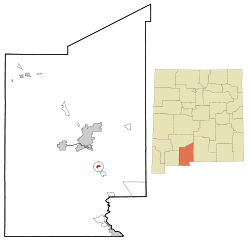
Coordinates: 32°9′47″N 106°41′36″W / 32.16306°N 106.69333°WCoordinates: 32°9′47″N 106°41′36″W / 32.16306°N 106.69333°W Country United States State New Mexico County Dona Ana Area – Total 0.8 sq mi (2.1 km2) – Land 0.8 sq mi (2.1 km2) – Water 0.0 sq mi (0.0 km2) Elevation 3,839 ft (1,170 m) Population (2000) – Total 948 – Density 1,148.2/sq mi (443.3/km2) Time zone Mountain (MST) (UTC-7) – Summer (DST) MDT (UTC-6) ZIP code 88048 Area code(s) 575 FIPS code 35-48270 GNIS feature ID 0899792 Mesquite is a census-designated place (CDP) in Doña Ana County, New Mexico, United States. The population was 948 at the 2000 census. It is part of the Las Cruces Metropolitan Statistical Area.
Geography
Mesquite is located at 32°9′47″N 106°41′36″W / 32.16306°N 106.69333°W (32.162976, -106.693434)[1].
According to the United States Census Bureau, the CDP has a total area of 0.8 square miles (2.1 km2), all of it land.
Demographics
As of the census[2] of 2000, there were 948 people, 262 households, and 227 families residing in the CDP. The population density was 1,148.2 people per square mile (441.0/km²). There were 276 housing units at an average density of 334.3 per square mile (128.4/km²). The racial makeup of the CDP was 65.30% White, 0.42% African American, 0.84% Native American, 0.11% Asian, 29.01% from other races, and 4.32% from two or more races. Hispanic or Latino of any race were 94.83% of the population.
There were 262 households out of which 54.2% had children under the age of 18 living with them, 65.3% were married couples living together, 16.8% had a female householder with no husband present, and 13.0% were non-families. 9.5% of all households were made up of individuals and 3.4% had someone living alone who was 65 years of age or older. The average household size was 3.62 and the average family size was 3.86.
In the CDP the population was spread out with 38.1% under the age of 18, 13.4% from 18 to 24, 26.2% from 25 to 44, 14.9% from 45 to 64, and 7.5% who were 65 years of age or older. The median age was 24 years. For every 100 females there were 95.1 males. For every 100 females age 18 and over, there were 90.6 males.
The median income for a household in the CDP was $21,875, and the median income for a family was $21,458. Males had a median income of $20,370 versus $15,577 for females. The per capita income for the CDP was $7,129. About 38.4% of families and 43.4% of the population were below the poverty line, including 49.7% of those under age 18 and 15.9% of those age 65 or over.
References
- ^ "US Gazetteer files: 2010, 2000, and 1990". United States Census Bureau. 2011-02-12. http://www.census.gov/geo/www/gazetteer/gazette.html. Retrieved 2011-04-23.
- ^ "American FactFinder". United States Census Bureau. http://factfinder.census.gov. Retrieved 2008-01-31.
Municipalities and communities of Doña Ana County, New Mexico Cities 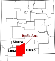
Town Village CDPs Chaparral | Doña Ana | Mesquite | Radium Springs | Rincon | Salem | Santa Teresa | University Park | Vado | White Sands
Other
communitiesBerino | Organ
Ghost town Lanark
Categories:- Populated places in Doña Ana County, New Mexico
- Census-designated places in New Mexico
- Populated places in New Mexico with Hispanic majority populations


Wikimedia Foundation. 2010.