- Salzburg Slate Alps
-
Salzburg Slate Alps Range  Salzach valley with Burg Hohenwerfen
Country  Austria
State  Salzburg
Part of Central Eastern Alps Highest point Hundstein - elevation 2,117 m (6,946 ft) - coordinates 47°20′17″N 12°54′40″E / 47.33806°N 12.91111°E 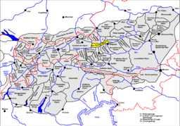 Location of the Salzburg Slate Alps
The Salzburg Slate Alps (German: Salzburger Schieferalpen) are a group of mountains in the Central Eastern Alps in the Austrian state of Salzburg. Situated within the greywacke zone, they are also regarded as part of the Northern Limestone Alps.
The range is located between the Kitzbühel Alps, the continuation of the greywacke zone beyond Lake Zeller and Saalach river in the west, and the Dachstein massif in the east. In the north it is adjacent to the Berchtesgaden Alps, while in the south the Salzach valley separates it from the Hohe Tauern.
See also
- Salzburg
- Salzburgerland
Coordinates: 47°23′N 13°13′E / 47.39°N 13.21°E
Allgäu Alps | Ammergau Alps | Bavarian Prealps | Berchtesgaden Alps | Brandenberg Alps | Bregenzerwaldgebirge | Chiemgau Alps | Dachstein | Ennstal Alps | Gutenstein Alps | Hochschwab | Kaisergebirge | Karwendel | Lechquellengebirge | Lechtal Alps | Leoganger Steinberge | Loferer Steinberge | Mieminger Chain | Mürzsteg Alps | Upper Austrian Prealps | Rax-Schneeberg Group | Rofangebirge | Salzburg Slate Alps | Salzkammergut Mountains | Tennengebirge | Totes Gebirge | Türnitz Alps | Wetterstein | Vienna Woods | Ybbstal Alps
Albula Alps | Pohorje (Bachergebirge) | Bernina Alps | Gurktal Alps | Lavanttal Alps | Livigno Alps | Ortler Alps | Ötztal Alps | Oberhalbstein Range | Plessur Alps | Foothills east of the Mur |
Rätikon | Samnaun Alps | Sarntal Alps | Salzburg and Tyrolean Slate Alps (Kitzbühel Alps) | Sesvenna Range | Silvretta Alps | Sobretta-Gavia Group | Stubai Alps | Tux Alps | High Tauern |
Low Tauern | Verwall Alps | Zillertal Alps Categories:
- Northern Limestone Alps
- Mountain ranges of the Alps
- Central Alps
- Geography of Salzburg
- Salzburg Slate Alps
- Salzburg geography stubs


Wikimedia Foundation. 2010.