- National Register of Historic Places listings in Santa Cruz County, Arizona
-
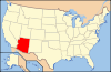
 Location of Santa Cruz County in Arizona
This is a list of the National Register of Historic Places listings in Santa Cruz County, Arizona. It is intended to be a complete list of the properties and districts on the National Register of Historic Places in Santa Cruz County, Arizona, United States. The locations of National Register properties and districts for which the latitude and longitude coordinates are included below, may be seen in a Google map.[1]
There are 52 properties and districts listed on the National Register in the county, including 3 that are also National Historic Landmarks.
-
- This National Park Service list is complete through NPS recent listings posted November 10, 2011.[2]
Current listings
[3] Landmark name Image Date listed Location City or town Summary 1 10 Cottages on Short Street August 29, 1985 117-126 Short
31°20′00″N 110°56′14″W / 31.333333°N 110.937222°WNogales 2 Arizona-Sonora Manufacturing Company Machine Shop August 29, 1985 Grand Ave. at Arroyo Boulevard
31°20′23″N 110°56′14″W / 31.339722°N 110.937222°WNogales 3 Atascosa Lookout House January 28, 1988 Coronado National Forest
31°25′33″N 111°08′47″W / 31.425833°N 111.146389°WTubac 4 Barrio de Tubac Archeological District September 12, 2003 Address Restricted Tubac 5 Bowman Hotel August 29, 1985 314-316 Grand Ave.
31°20′12″N 110°56′22″W / 31.336667°N 110.939444°WNogales 6 W.G. Bowman House August 29, 1985 112 Sierra
31°20′33″N 110°56′11″W / 31.3425°N 110.936389°WNogales 7 Burton Building August 29, 1985 322-324 Grande
31°20′14″N 110°56′21″W / 31.337222°N 110.939167°WNogales 8 Cady Hall December 2, 1992 346 Duquesne St.
31°32′19″N 110°45′13″W / 31.538611°N 110.753611°WPatagonia 9 Calabasas 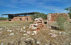
June 3, 1971 North of Nogales
31°27′41″N 110°58′00″W / 31.461389°N 110.966667°WNogales 10 Canelo Ranger Station June 10, 1993 Forest Rd. 52B north of Canelo in the Coronado National Forest
31°33′05″N 110°30′59″W / 31.551389°N 110.516389°WCanelo 11 Canelo School July 31, 1991 18 miles southeast of Sonoita on State Route 93
31°32′32″N 110°30′36″W / 31.542222°N 110.51°WCanelo 12 Frank F. Cranz House August 29, 1985 408 Arroyo
31°20′19″N 110°56′24″W / 31.338611°N 110.94°WNogales 13 Crawford Hill Historic Residential District August 29, 1985 Roughly bounded by Oak St., Terrace Ave., Compound St., and Interstate 19 and Grindell
31°20′07″N 110°56′12″W / 31.335278°N 110.936667°WNogales 14 George Dunbar House August 29, 1985 118 Sierra
31°20′34″N 110°56′10″W / 31.342778°N 110.936111°WNogales 15 James Finley House November 19, 1974 7.2 miles southwest of Patagonia in the Coronado National Forest
31°27′55″N 110°42′24″W / 31.465278°N 110.706667°WPatagonia 16 Guevavi Mission Ruins 
November 5, 1971 6 miles north of U.S./Mexico border
31°24′36″N 110°54′10″W / 31.41°N 110.902778°WNogales 17 Sen. James A. Harrison House August 29, 1985 449 Morley
31°20′17″N 110°56′10″W / 31.338056°N 110.936111°WNogales 18 Hotel Blanca August 29, 1985 701 Morley
31°20′25″N 110°56′01″W / 31.340278°N 110.933611°WNogales 19 House at 220 Walnut Street August 29, 1985 220 Walnut St.
31°20′21″N 110°56′30″W / 31.339167°N 110.941667°WNogales 20 House at 334-338 Walnut Street August 29, 1985 334-338 Walnut St.
31°20′23″N 110°56′36″W / 31.339722°N 110.943333°WNogales 21 House at 665 Morley Avenue August 29, 1985 665 Morley Ave.
31°20′25″N 110°56′02″W / 31.340278°N 110.933889°WNogales 22 Kentucky Camp Historic District 
November 22, 1995 Near Forest Road 163 off State Route 83
31°44′13″N 110°43′43″W / 31.73694°N 110.72861°W[4]Coronado National Forest 23 Pete Kitchen Ranch 
February 20, 1975 3.5 miles north of Nogales off U.S. Route 89
31°24′08″N 110°57′16″W / 31.402222°N 110.954444°WNogales 24 S.H. Kress & Co. Building August 29, 1985 119-121 Morley
31°20′00″N 110°56′24″W / 31.333333°N 110.94°WNogales 25 Las Dos Naciones Cigar Factory August 29, 1985 331 Morley
31°20′08″N 110°56′17″W / 31.335556°N 110.938056°WNogales 26 The Little Outfit Schoolhouse 
January 8, 2009 571 Canelo Pass Road
31°29′43″N 110°34′25″W / 31.495278°N 110.573611°WPatagonia Ranch school opened 1940, grades 3 to 8, teaching ideals of the West 27 Marsh Heights Historic District October 29, 1985 Roughly bounded by Court St., Summit Ave., S. Court St., and Morley Ave.
31°20′09″N 110°56′38″W / 31.335833°N 110.943889°WNogales 28 George B. Marsh Building August 29, 1985 213-225 Grand
31°20′08″N 110°56′22″W / 31.335556°N 110.939444°WNogales 29 Mediterranean Style House August 29, 1985 116 Walnut
31°20′18″N 110°56′24″W / 31.338333°N 110.94°WNogales 30 Mediterranean Style House August 29, 1985 124 Walnut
31°20′18″N 110°56′26″W / 31.338333°N 110.940556°WNogales 31 Hugo Miller House August 29, 1985 750 Petrero
31°20′33″N 110°56′05″W / 31.3425°N 110.934722°WNogales 32 Montezuma Hotel August 29, 1985 217 Morley
31°20′02″N 110°56′23″W / 31.333889°N 110.939722°WNogales 33 Nogales Electric Light, Ice & Water Company Power House August 29, 1985 498 Grand
31°20′26″N 110°55′37″W / 31.340556°N 110.926944°WNogales 34 Nogales High School August 29, 1985 209 Plum
31°20′25″N 110°56′26″W / 31.340278°N 110.940556°WNogales 35 Nogales Steam Laundry Building August 29, 1985 223-219 East
31°20′02″N 110°56′17″W / 31.333889°N 110.938056°WNogales 36 A.S. Noon Building August 29, 1985 246 Grande
31°20′10″N 110°56′23″W / 31.336111°N 110.939722°WNogales 37 Old Nogales City Hall and Fire Station April 3, 1980 223 Grand Ave.
31°20′05″N 110°56′26″W / 31.334722°N 110.940556°WNogales 38 Old Tubac Schoolhouse November 10, 1970 Address unknown
31°36′43″N 111°02′45″W / 31.611944°N 111.045833°WTubac 39 Pennington Rural Historic Landscape February 10, 2000 North of the junction of Royal Rd. and Calle Del Rio
31°20′55″N 110°50′52″W / 31.348611°N 110.847778°WNogales 40 Jose Piscorski Building August 29, 1985 315 Morley
31°20′07″N 110°56′19″W / 31.335278°N 110.938611°WNogales 41 Ruby 
April 28, 1975 North of the U.S./Mexico border between Ruby and Montana peaks
31°29′01″N 111°14′14″W / 31.483611°N 111.237222°WRuby 42 San Rafael Ranch Historic District February 7, 2008 HC 2 Box 200 Patagonia 43 Santa Cruz Bridge No. 1 September 30, 1988 South River Rd. over the Santa Cruz River
31°23′19″N 110°52′25″W / 31.388611°N 110.873611°WNogales 44 Santa Cruz County Courthouse 
December 7, 1977 Court and Morley Sts.
31°20′11″N 110°56′15″W / 31.336389°N 110.9375°WNogales 45 Three Mediterranean Cottages on Pajarito Street August 29, 1985 102-104 Pajarito
31°20′30″N 110°56′08″W / 31.341667°N 110.935556°WNogales 46 Tubac Presidio 
December 2, 1970 Broadway and River Rd.
31°36′43″N 111°02′41″W / 31.611944°N 111.044722°WTubac 47 Tubac Townsite Historic District October 17, 1994 Roughly bounded by Tubac and Plaza Rds. and Presidio Dr.
31°36′44″N 111°02′43″W / 31.612222°N 111.045278°WTubac 48 Tumacacori Museum May 28, 1987 Tumacacori National Monument
31°34′4″N 111°3′1″W / 31.56778°N 111.05028°WTumacacori 49 Tumacacori National Monument 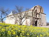
October 15, 1966 18 miles north of Nogales on Interstate 19
31°34′7″N 111°2′58″W / 31.56861°N 111.04944°WTumacacori Mission site that was declared a National Monument and has since been converted to a National Historical Park 50 U.S. Custom House August 6, 1987 Junction of International and Terrace Sts.
31°19′59″N 110°56′33″W / 31.333056°N 110.9425°WNogales 51 US Post Office and Immigration Station-Nogales Main December 3, 1985 Hudgin St. and Morley Ave.
31°20′15″N 110°56′12″W / 31.3375°N 110.936667°WNogales 52 J.E. Wise Building August 29, 1985 134 Grande
31°20′04″N 110°56′28″W / 31.334444°N 110.941111°WNogales See also
- List of National Historic Landmarks in Arizona
- National Register of Historic Places listings in Arizona
References
- ^ The latitude and longitude information provided in this table was derived originally from the National Register Information System, which has been found to be fairly accurate for about 99% of listings. For about 1% of NRIS original coordinates, experience has shown that one or both coordinates are typos or otherwise extremely far off; some corrections may have been made. A more subtle problem causes many locations to be off by up to 150 yards, depending on location in the country: most NRIS coordinates were derived from tracing out latitude and longitudes off of USGS topographical quadrant maps created under the North American Datum of 1927, which differs from the current, highly accurate WGS84 GPS system used by Google maps. Chicago is about right, but NRIS longitudes in Washington are higher by about 4.5 seconds, and are lower by about 2.0 seconds in Maine. Latitudes differ by about 1.0 second in Florida. Some locations in this table may have been corrected to current GPS standards.
- ^ "National Register of Historic Places: Weekly List Actions". National Park Service, United States Department of the Interior. Retrieved on November 10, 2011.
- ^ Numbers represent an ordering by significant words. Various colorings, defined here, differentiate National Historic Landmark sites and National Register of Historic Places Districts from other NRHP buildings, structures, sites or objects.
- ^ Location derived from this Tucson Weekly article; the NRIS lists the site as "Address Restricted"
U.S. National Register of Historic Places Topics Lists by states Alabama • Alaska • Arizona • Arkansas • California • Colorado • Connecticut • Delaware • Florida • Georgia • Hawaii • Idaho • Illinois • Indiana • Iowa • Kansas • Kentucky • Louisiana • Maine • Maryland • Massachusetts • Michigan • Minnesota • Mississippi • Missouri • Montana • Nebraska • Nevada • New Hampshire • New Jersey • New Mexico • New York • North Carolina • North Dakota • Ohio • Oklahoma • Oregon • Pennsylvania • Rhode Island • South Carolina • South Dakota • Tennessee • Texas • Utah • Vermont • Virginia • Washington • West Virginia • Wisconsin • WyomingLists by territories Lists by associated states Other Properties on the National Register of Historic Places in Arizona 
Municipalities and communities of Santa Cruz County, Arizona City 
Town CDPs Ghost towns Alto | Calabasas | Canelo | Duquesne | Harshaw | Mowry | Oro Blanco | Ruby | Salero
Categories:- National Register of Historic Places in Arizona by county
- Santa Cruz County, Arizona
- History of Santa Cruz County, Arizona
-


Wikimedia Foundation. 2010.