- Drumskinny
-
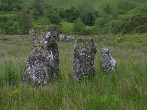 Some of the standing stones at Drumskinny, Ireland
Drumskinny (from Irish: Droim Scine meaning "knife ridge") is the site of a stone circle in the townland of Drumskinny, County Fermanagh, Northern Ireland. With the inclusion of an adjacent cairn and alignment, the stone circle is a State Care Historic Monument in Fermanagh District Council area, at grid ref: H 2009 7072.[1][2] The site was excavated in 1962[3] and is believed to have built around 2000 BC.[4]
See also
- List of townlands in County Fermanagh
External links
References
- ^ "Drumskinny". Environment and Heritage Service NI - State care Historic Monuments. http://www.ehsni.gov.uk/state_care_monuments_2007.pdf. Retrieved 2007-12-03.
- ^ "Drumskinny". The Megalithic Portal. http://www.megalithic.co.uk/article.php?sid=354. Retrieved 2007-12-02.
- ^ "Drumskinny Stone Circle". Irish Antiquities. http://irishantiquities.bravehost.com/fermanagh/drumskinny/drumskinny.html. Retrieved 2010-10-06.
- ^ "Drumskinny Stone Circle". Triskelle. http://www.triskelle.eu/attractions/drumskinnystonecircle.php?index=100.040.008.060.005. Retrieved 2007-12-02.
Places in County Fermanagh List of places in County Fermanagh Towns Villages
and townlandsAghadrumsee • Aghakeeran • Aghanaglack • Arney • Ballinamallard • Ballycassidy • Belcoo • Bellanaleck • Belleek • Blaney • Boho • Brookeborough • Carn • Carr • Castle Balfour • Castle Coole • Clabby • Clogherbog • Derrygonnelly • Derrylin • Derryvore • Donagh • Drumbegger • Drumlaghy • Drumskinny • Ederny • Florencecourt • Garrison • Glenkeel • Holywell • Irvinestown • Kesh • Killadeas • Kilnamadoo • Killydrum • Kinawly • Knockmore • Knocknahunshin • Knocks • Lack • Laragh • Letterbreen • Levally Lower • Lisbellaw • Lisnarick • Lisnaskea • Macken • Magheraveely • Maguiresbridge • Monea • Moylehid • Newtownbutler • Pettigo • Reyfad • Rosslea • Skea • Springfield • Tamlaght • Tattykeeran • Teemore • Tempo • Trory • Tullyhommon • TullygerravraLandforms Badger Pot • Boa Island • Belmore • Benaughlin • Caves of Tullybrack and Belmore hills • Cliffs of Magho • Cuilcagh • Devinish • Hanging Rock • Knockmore • Lough Erne • Lough MacNean • Lough Melvin • Lustybeg Island • Lustymore Island • Marble Arch Caves • Slieve Beag • Slieve Rushen • White IslandBaronies WikiProject Northern Ireland · WikiProject Ireland · Northern Ireland Portal · United Kingdom Portal · Ireland Portal Coordinates: 54°35′04″N 7°41′26″W / 54.5844352461°N 7.69051657806°W
Categories:- Archaeological sites in County Fermanagh
- Stone circles in Northern Ireland
- Townlands in County Fermanagh
- Prehistoric sites in Northern Ireland

Wikimedia Foundation. 2010.