- Cucklington
-
Coordinates: 51°02′47″N 2°21′03″W / 51.0463°N 2.3508°W
Cucklington 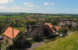
Cucklington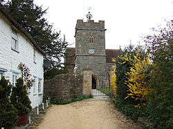
Church of St Lawrence
 Cucklington
Cucklington shown within SomersetPopulation 167 [1] OS grid reference ST755275 District South Somerset Shire county Somerset Region South West Country England Sovereign state United Kingdom Post town WINCANTON Postcode district BA9 Dialling code 01963 Police Avon and Somerset Fire Devon and Somerset Ambulance South Western EU Parliament South West England UK Parliament Somerton and Frome List of places: UK • England • Somerset Cucklington is a village and parish in Somerset, England, situated on a hill 3 miles (4.8 km) south east of Wincanton and 4 miles (6.4 km) north west of Gillingham in the South Somerset district, near the Dorset border. The village has a population of 167.[1]
Contents
History
 Shanks House.
The name Cucklington comes from Old English meaning the settlement of Cucola's people.[2]
The parish of Cucklington was part of the Norton Ferris Hundred.[3]
Shanks House has medieval fragments, but had major works in the 17th and 18th centuries, including refitting by Nathaniel Ireson. It has been designated as a Grade I listed building.[4]
Governance
The parish council has responsibility for local issues, including setting an annual precept (local rate) to cover the council’s operating costs and producing annual accounts for public scrutiny. The parish council evaluates local planning applications and works with the local police, district council officers, and neighbourhood watch groups on matters of crime, security, and traffic. The parish council's role also includes initiating projects for the maintenance and repair of parish facilities, as well as consulting with the district council on the maintenance, repair, and improvement of highways, drainage, footpaths, public transport, and street cleaning. Conservation matters (including trees and listed buildings) and environmental issues are also the responsibility of the council.
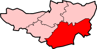
The village falls within the Non-metropolitan district of South Somerset, which was formed on April 1, 1974 under the Local Government Act 1972, having previously been part of Wincanton Rural District.[5] The district council is responsible for local planning and building control, local roads, council housing, environmental health, markets and fairs, refuse collection and recycling, cemeteries and crematoria, leisure services, parks, and tourism.
Somerset County Council is responsible for running the largest and most expensive local services such as education, social services, libraries, main roads, public transport, policing and fire services, trading standards, waste disposal and strategic planning.
It is also part of the Somerton and Frome county constituency represented in the House of Commons of the Parliament of the United Kingdom. It elects one Member of Parliament (MP) by the first past the post system of election, and part of the South West England constituency of the European Parliament which elects seven MEPs using the d'Hondt method of party-list proportional representation.
Religious sites
The parish church of St Lawrence dates from the 13th century.[6]
References
- ^ a b "South Somerset population estimates for 2002". Somerset County Council. http://www.webcitation.org/5lRyCVNCk. Retrieved 27 December 2009.
- ^ Bush, Robin (1994). Somerset: The Complete Guide. Dovecote Press. pp. 78. ISBN 1874336261.
- ^ "Somerset Hundreds". GENUKI. http://www.genuki.org.uk/big/eng/SOM/Miscellaneous/. Retrieved 18 October 2011.
- ^ "Shanks House". Images of England. English Heritage. http://www.imagesofengland.org.uk/Details/Default.aspx?id=261716. Retrieved 2008-10-12.
- ^ A Vision of Britain Through Time : Wincanton Rural District
- ^ "Church of St Lawrence". Images of England. English Heritage. http://www.imagesofengland.org.uk/Details/Default.aspx?id=261698. Retrieved 2008-10-12.
External links
 Media related to Cucklington at Wikimedia CommonsCategories:
- Villages in South Somerset
- Civil parishes in Somerset


Wikimedia Foundation. 2010.