- National Register of Historic Places listings in Butler County, Kentucky
-
 Location of Butler County in Kentucky
This is a list of the National Register of Historic Places listings in Butler County, Kentucky.
This is intended to be a complete list of the properties and districts on the National Register of Historic Places in Butler County, Kentucky, United States. The locations of National Register properties and districts for which the latitude and longitude coordinates are included below, may be seen in a Google map.[1]
There are 17 properties and districts listed on the National Register in the county.
-
- This National Park Service list is complete through NPS recent listings posted November 10, 2011.[2]
Current listings
[3] Landmark name Image Date listed Location City or town Summary 1 Annis Mound and Village Site (15BT2; 15BT20; 15BT21) December 21, 1985 Address Restricted Logansport 2 Baby Track Rock Petroglyphs (15BT40) September 8, 1989 Address Restricted Morgantown 3 Carlston Annis Shell Mound (15BT5) April 1, 1986 Address Restricted Schulztown 4 Carson's Landing July 31, 1998 1086 Annis Ferry Rd.
37°17′38″N 86°45′08″W / 37.293889°N 86.752222°WMorgantown 5 John Carson House July 26, 1991 205 S. Main St.
37°13′28″N 86°41′06″W / 37.224444°N 86.685°WMorgantown 6 Carson-Annis Ferry Farm April 10, 2007 1086 Annis Ferry Rd. Morgantown 7 Confederate-Union Veterans' Monument in Morgantown 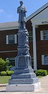
July 17, 1997 1 block north of the junction of U.S. Route 231 and KY 403
37°13′31″N 86°40′59″W / 37.225278°N 86.683056°WMorgantown 8 DeWeese Shell Mound (15BT6) April 1, 1986 Address Restricted Highview 9 Finney Hotel November 7, 1995 Junction of KY 403 and Hime St.
37°11′03″N 86°38′01″W / 37.184167°N 86.633611°WWoodbury 10 Ice House on Little Muddy Creek January 8, 1987 U.S. Route 231
37°09′12″N 86°40′32″W / 37.153333°N 86.675556°WMorgantown 11 Rayburn Johnson Shell Mound (15BT41) April 1, 1986 Address Restricted Prentiss 12 Read Shell Mound (15BT10) April 1, 1986 Address Restricted Monticello 13 Reedyville Petroglyphs (15BT65) September 8, 1989 Address Restricted Reedyville 14 Russell Shell Mound (15BT11) April 1, 1986 Address Restricted Logansport 15 Turkey Rock Petroglyphs (15BT64) September 8, 1989 Address Restricted Morgantown 16 U.S. Army Corps of Engineers Superintendent's House and Workmen's Office June 19, 1980 Woodbury Park
37°11′06″N 86°37′57″W / 37.185°N 86.6325°WWoodbury 17 Woodbury Shell Midden (15BT67) April 1, 1986 Address Restricted Woodbury See also
- List of National Historic Landmarks in Kentucky
- National Register of Historic Places listings in Kentucky
References
- ^ The latitude and longitude information provided in this table was derived originally from the National Register Information System, which has been found to be fairly accurate for about 99% of listings. For about 1% of NRIS original coordinates, experience has shown that one or both coordinates are typos or otherwise extremely far off; some corrections may have been made. A more subtle problem causes many locations to be off by up to 150 yards, depending on location in the country: most NRIS coordinates were derived from tracing out latitude and longitudes off of USGS topographical quadrant maps created under the North American Datum of 1927, which differs from the current, highly accurate WGS84 GPS system used by Google maps. Chicago is about right, but NRIS longitudes in Washington are higher by about 4.5 seconds, and are lower by about 2.0 seconds in Maine. Latitudes differ by about 1.0 second in Florida. Some locations in this table may have been corrected to current GPS standards.
- ^ "National Register of Historic Places: Weekly List Actions". National Park Service, United States Department of the Interior. Retrieved on November 10, 2011.
- ^ Numbers represent an ordering by significant words. Various colorings, defined here, differentiate National Historic Landmark sites and National Register of Historic Places Districts from other NRHP buildings, structures, sites or objects.
U.S. National Register of Historic Places Topics Lists by states Alabama • Alaska • Arizona • Arkansas • California • Colorado • Connecticut • Delaware • Florida • Georgia • Hawaii • Idaho • Illinois • Indiana • Iowa • Kansas • Kentucky • Louisiana • Maine • Maryland • Massachusetts • Michigan • Minnesota • Mississippi • Missouri • Montana • Nebraska • Nevada • New Hampshire • New Jersey • New Mexico • New York • North Carolina • North Dakota • Ohio • Oklahoma • Oregon • Pennsylvania • Rhode Island • South Carolina • South Dakota • Tennessee • Texas • Utah • Vermont • Virginia • Washington • West Virginia • Wisconsin • WyomingLists by territories Lists by associated states Other Municipalities and communities of Butler County, Kentucky Cities  Categories:
- National Register of Historic Places in Kentucky by county
- Butler County, Kentucky
-


Wikimedia Foundation. 2010.