- National Register of Historic Places listings in Dillingham Census Area, Alaska
-
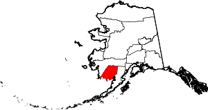 Location of the Dillingham Census Area in Alaska
This is a list of the National Register of Historic Places listings in Dillingham Census Area, Alaska.
This is intended to be a complete list of the properties and districts on the National Register of Historic Places in Dillingham Census Area, Alaska, United States. The locations of National Register properties and districts for which the latitude and longitude coordinates are included below, may be seen in a Google map.[1]
There are 13 properties and districts listed on the National Register in the census area.
-
- This National Park Service list is complete through NPS recent listings posted November 10, 2011.[2]
Current listings
[3] Landmark name[4] Image Date listed Location Community Summary 1 Amalik Bay Archeological District April 5, 2005 Katmai National Park and Preserve-Address Restricted King Salmon 2 Aniakchak Bay Historic Landscape District 
February 14, 1997 Surrounding the Aniakchak River from Aniakchak Crater to Aniakchak Bay in the Aniakchak National Preserve
56°45′14″N 157°30′57″W / 56.75389°N 157.51583°WChignik 3 Archeological Site 49 AF 3 February 17, 1978 Address Restricted Kanatak 4 Brooks Camp Boat House March 15, 2010 Shore of Naknek Lake, just north of the Brooks River Mouth in Katmai National Park and Preserve King Salmon 5 Brooks River Historic Ranger Station March 15, 2010 Shore of Naknek Lake, just north of the Brooks River Mouth in Katmai National Park and Preserve King Salmon 6 DIL-161 Site January 22, 2007 Address Restricted Alagnak Wild River 7 Kaguyak Village Site June 23, 1978 Address Restricted Kanatak 8 Kukak Village Site 
July 20, 1978 At the entrance to Kukak Bay
58°20′51″N 154°12′28″W / 58.3475°N 154.20778°W[5]Kanatak 9 Pilgrim 100B Aircraft August 7, 1986 Dillingham Municipal Airport
59°2′35″N 158°27′29″W / 59.04306°N 158.45806°WDillingham 10 St. Nicholas Chapel June 6, 1980 In Ekuk
58°47′53″N 158°32′54″W / 58.79806°N 158.54833°WEkuk 11 St. Nicholas Chapel June 6, 1980 In Igiugig
59°20′5″N 155°32′27″W / 59.33472°N 155.54083°WIgiugig 12 Takli Island Archeological District May 23, 1978 Address Restricted Kanatak 13 Transfiguration of Our Lord Chapel June 6, 1980 In Nushagak
58°56′54″N 158°29′21″W / 58.94833°N 158.48917°WNushagak See also
- List of National Historic Landmarks in Alaska
- National Register of Historic Places listings in Alaska
References
- ^ The latitude and longitude information provided in this table was derived originally from the National Register Information System, which has been found to be fairly accurate for about 99% of listings. For about 1% of NRIS original coordinates, experience has shown that one or both coordinates are typos or otherwise extremely far off; some corrections may have been made. A more subtle problem causes many locations to be off by up to 150 yards, depending on location in the country: most NRIS coordinates were derived from tracing out latitude and longitudes off of USGS topographical quadrant maps created under the North American Datum of 1927, which differs from the current, highly accurate WGS84 GPS system used by Google maps. Chicago is about right, but NRIS longitudes in Washington are higher by about 4.5 seconds, and are lower by about 2.0 seconds in Maine. Latitudes differ by about 1.0 second in Florida. Some locations in this table may have been corrected to current GPS standards.
- ^ "National Register of Historic Places: Weekly List Actions". National Park Service, United States Department of the Interior. Retrieved on November 10, 2011.
- ^ Numbers represent an ordering by significant words. Various colorings, defined here, differentiate National Historic Landmark sites and National Register of Historic Places Districts from other NRHP buildings, structures, sites or objects.
- ^ "National Register Information System". National Register of Historic Places. National Park Service. 2008-04-24. http://nrhp.focus.nps.gov/natreg/docs/All_Data.html.
- ^ Location derived from Katmai National Park Information Page, Katmai National Park and Preserve, 2007. Accessed 2011-04-05.
U.S. National Register of Historic Places Topics Lists by states Alabama • Alaska • Arizona • Arkansas • California • Colorado • Connecticut • Delaware • Florida • Georgia • Hawaii • Idaho • Illinois • Indiana • Iowa • Kansas • Kentucky • Louisiana • Maine • Maryland • Massachusetts • Michigan • Minnesota • Mississippi • Missouri • Montana • Nebraska • Nevada • New Hampshire • New Jersey • New Mexico • New York • North Carolina • North Dakota • Ohio • Oklahoma • Oregon • Pennsylvania • Rhode Island • South Carolina • South Dakota • Tennessee • Texas • Utah • Vermont • Virginia • Washington • West Virginia • Wisconsin • WyomingLists by territories Lists by associated states Other Properties on the National Register of Historic Places in Alaska  Boroughs
 Census areasAleutians West • Bethel • Dillingham • Hoonah-Angoon • Nome • Petersburg • Prince of Wales-Hyder • Southeast Fairbanks • Valdez-Cordova • Yukon-KoyukukThere are no sites listed on the National Register of Historic Places in Wade Hampton Census Area
Municipalities and communities of Dillingham Census Area, Alaska Cities Aleknagik | Clark's Point | Dillingham | Ekwok | Manokotak | New Stuyahok | Togiak

CDPs Unincorporated
communitiesCategories:- National Register of Historic Places in Alaska by borough and census area
- Dillingham Census Area, Alaska
-


Wikimedia Foundation. 2010.