- Moundville Archaeological Site
-
Moundville Archaeological Site
 A view of the site from the top of Mound B looking toward Mound A and the plaza.
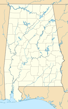

Location: 634 Mound State Parkway
Moundville, Alabama, USANearest city: Tuscaloosa Coordinates: 33°0′16.81″N 87°37′51.85″W / 33.0046694°N 87.6310694°WCoordinates: 33°0′16.81″N 87°37′51.85″W / 33.0046694°N 87.6310694°W Governing body: University of Alabama NRHP Reference#: 66000149 Significant dates Added to NRHP: October 15, 1966[1] Designated NHL: July 19, 1964 [2] Moundville Archaeological Site, also known as the Moundville Archaeological Park, is a Mississippian site on the Black Warrior River in Hale County, near the town of Tuscaloosa, Alabama.[3] Extensive archaeological investigation has shown that the site was the political and ceremonial center of a regionally organized Mississippian culture chiefdom polity between the 11th and 16th centuries. The archaeological park portion of the site is administered by the University of Alabama Museums and encompasses 172 acres (70 ha), consisting of 32 platform mounds around a rectangular plaza.[3] The site was declared a National Historic Landmark in 1964 and was added to the National Register of Historic Places in 1966.[2]
Moundville is the second-largest site of the classic Middle Mississippian era, after Cahokia in Illinois. The culture was expressed in villages and chiefdoms throughout the central Mississippi River Valley, the lower Ohio River Valley, and most of the Mid-South area, including Kentucky, Tennessee, Alabama, and Mississippi as the core of the classic Mississippian culture area.[4] The park contains a museum and an archaeological laboratory.
Contents
The site
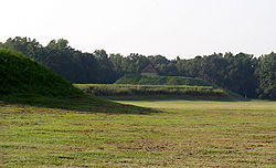 A view across the plaza from mound J to mound B, with mound A in the center.
The site was occupied by Native Americans of the Mississippian culture from around 1000 AD to 1450 AD.[3] Around 1150 AD it began its rise from a local to a regional center. At its height, the community took the form of a roughly 300-acre (121 ha) residential and political area protected on three sides by a bastioned wooden palisade wall, with the remaining side protected by the river bluff.[3] The largest platform mounds are located on the northern edge of the plaza and become increasingly smaller going either clockwise or counter clockwise around the plaza to the south. Scholars theorize that the highest-ranking clans occupied the large northern mounds with the smaller mounds' supporting buildings used for residences, mortuary, and other purposes.[3] Of the two largest mounds in the group, Mound A occupies a central position in the great plaza, and Mound B lies just to the north, a steep, 58 feet (18 m) tall pyramidal mound with two access ramps which rises to a height of 58 feet.[3] Along with both mounds archaeologists have also found evidence of burrow pits, other public buildings and a dozen of small houses constructed of pole and thatch.
Archaeologists have interpreted this community plan as a sociogram, an architectural depiction of a social order based on ranked clans. According to this model, the Moundville community was segmented into a variety of different clan precincts, the ranked position of which was represented in the size and arrangement of paired earthen mounds around the central plaza. By 1300 the site was being used more as a religious and political center than as a residential town.[3] This signaled the beginning of a decline, and by 1500 most of the area was abandoned.[3]
The people
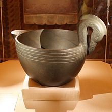
 Exotic Mississippian culture pottery found at the Moundville Site
 Engraved stone palette from Moundville, illustrating a horned rattlesnake, perhaps The Great Serpent
The surrounding area appears to have been heavily populated but the people built relatively few mounds before the creation of the public architecture of the plaza and mounds after 1200 AD.[3] At its height, the population is estimated to have been around 1000 people within the walls, with 10,000 additional people in the surrounding countryside.[3] Based on findings during excavations, the residents of the site were skilled in agriculture, especially the cultivation of maize. Production of maize surpluses gave the people produce to trade for other goods, and also allowed the specialization of artisans.[3] Extensive amounts of imported luxury goods such as copper, mica, galena, and marine shell have been excavated from the site.[3] The site is renowned by scholars for the artistic excellence displayed by the artifacts of pottery, stonework, and embossed copper left by the former residents.[3]
Excavations
The first major excavations were done in 1905-06 by Clarence Bloomfield Moore, before archaeology had become professionalized. His work first brought the site national attention and contributed to the understanding of the Southeastern Ceremonial Complex.[5] One of his many discoveries was a finely carved diorite bowl depicting a crested wood duck. Although the state had shown little interest in the site, it was his removal of this and many other of the site's finest artifacts that prompted the Alabama Legislature to bar people from taking any other artifacts from the state. Despite the fact that archaeological techniques in general were relatively crude when compared to modern standards, some professionals have criticized Moore for his excavation techniques.[5]
The first large-scale scientific excavations of the site were done beginning in 1929 by Walter B. Jones, director of the Alabama Museum of Natural History and archaeologist David L. DeJarnette.[6] Current work continues to be done by Dr. Jim Knight, Curator of Southeastern Archaeology at the University of Alabama. He is conducting field research at Moundville with an emphasis on ethnohistorical reconstruction.[7]
Geography
The Moundville Archaeological Site is located on a bluff overlooking the Black Warrior River. The site and other affiliated settlements are located within a portion of the Black Warrior River Valley starting below the fall line, just south of Tuscaloosa, Alabama, and extending 25 miles (40 km) downriver. Below the fall line, the valley widens and the uplands consist of rolling hills dissected by intermittent streams. This region corresponds with the transition between the Piedmont and Coastal Plain and encompasses considerable physiographic and ecological diversity. Environmentally this portion of the Black Warrior Valley was an ecotone that had floral and faunal characteristics from temperate oak-hickory, maritime magnolia, and pine forests.
Film
The 2009 American independent film A Genesis Found was largely shot and set at the Moundville Archaeological Site. The plot revolves around a search for a supposed anomalous skeleton linked to the site's establishment. It features a dramatized dig from a University of Alabama Field School. The film also features dramatizations of Civilian Conservation Corps digs in the 1930s, as well as details about some of the site's more popular motifs and imagery.[8]
See also
- Mississippian culture
- Southeastern Ceremonial Complex
- List of Mississippian sites
- Mississippi Valley: Culture, phase, and chronological periods table - List of archaeological periods
- List of National Historic Landmarks in Alabama
 The carved diorite bowl from the site, depicting a crested wood duck. It is now displayed on-site at the Jones Archaeological Museum, on loan from the Smithsonian Institution's National Museum of the American Indian since May 2010.
References
- ^ "National Register Information System". National Register of Historic Places. National Park Service. 2007-01-23. http://nrhp.focus.nps.gov/natreg/docs/All_Data.html.
- ^ a b "Moundville Site". National Historic Landmark summary listing. National Park Service. http://tps.cr.nps.gov/nhl/detail.cfm?ResourceId=73&ResourceType=Site. Retrieved 2007-10-28.
- ^ a b c d e f g h i j k l m ""An Archaeological Sketch of Moundville"". "Moundville Archaeological Museum". Archived from the original on 2007-11-18. http://web.archive.org/web/20071118141709/http://www.ua.edu/academic/museums/moundville/sketch.html. Retrieved 2007-12-04.
- ^ ""Southeastern Prehistory: Mississippian and Late Prehistoric Period"". "National Park Service". http://www.nps.gov/history/seac/outline/05-mississippian/index.htm. Retrieved 2007-12-04.
- ^ a b ""Moundville: A Breathtaking Archaeological Find in Alabama"". "Laura Lee News". http://www.lauralee.com/news/moundville.htm. Retrieved 2007-12-13.
- ^ ""HistoricalStatement"". "University of Alabama: Office of Archaeological Research". Archived from the original on 2007-08-15. http://web.archive.org/web/20070815235149/http://museums.ua.edu/oar/history.html. Retrieved 2007-12-04.
- ^ ""Vernon J. Knight"". "Department of Anthropology". http://www.as.ua.edu/ant/index1.php?ID=7&fil=people. Retrieved 2007-12-13.[dead link]
- ^ http://www.imdb.com/title/tt1381773/
Further reading
- Knight, Vernon James, Jr. Mound Excavations at Moundville: Architecture, Elites, and Social Order (University of Alabama Press; 2010) 404
- Knight, Vernon James, Jr. 2004 "Characterizing Elite Midden Mounds at Moundville", American Antiquity 69(1):304-321.
- Knight, Vernon James, Jr. 1998 "Moundville as a Diagrammatic Ceremonial Center", Archaeology of the Moundville Chiefdom, edited by V.J. Knight Jr. and V.P. Steponaitis, pp. 44–62. Washington: Smithsonian Institution Press.
- Steponaitis, Vincas P. 1983 Ceramics, Chronology, and Community Patterns: An Archaeological Study at Moundville. Academic Press, New York.
- Welch, Paul D. 1991 Moundville's Economy. University of Alabama Press, Tuscaloosa.
- Welch, Paul D., and C. Margaret Scarry. 1995 "Status-related Variation in Foodways in the Moundville Chiefdom", American Antiquity 60:397-419.
- Wilson, Gregory D. 2008 The Archaeology of Everyday Life at Early Moundville, University of Alabama Press, Tuscaloosa.
External links
 Pre-Columbian North America
Archaeological cultures North American pre-Columbian chronology – Adena – Alachua – Ancient Pueblo (Anasazi) – Baytown – Belle Glade – Buttermilk Creek Complex – Caborn-Welborn – Calf Creek – Caloosahatchee – Clovis – Coles Creek – Deptford – Folsom – Fort Ancient – Fort Walton – Fremont – Glades – Glacial Kame – Hopewell (List of Hopewell sites) – Hohokam – Leon-Jefferson – Mississippian (List of Mississippian sites) – Mogollon – Monongahela – Old Cordilleran – Oneota – Paleo-Arctic – Paleo-Indians – Patayan – Plano – Plaquemine – Poverty Point – Prehistoric Southwest – Red Ocher – Santa Rosa-Swift Creek – St. Johns – Steed-Kisker – Tchefuncte – Tocobaga – Troyville
Archaeological sites Angel Mounds – Bandelier National Monument – The Bluff Point Stoneworks – Cahokia – Chaco Canyon – Casa Grande – Coso Rock Art District – Eaker – Effigy Mounds National Monument – Etowah Indian Mounds – Eva – Folsom Site – Fort Ancient – Fort Center – Gila Cliff Dwellings National Monument – Holly Bluff Site – Hopewell Culture National Historical Park – Kincaid Mounds – Kolomoki – Manitou Cliff Dwellings – Marksville – Meadowcroft Rockshelter – Mesa Verde – Moorehead Circle – Moundville – Mummy Cave – Nodena Site – Ocmulgee National Monument – Old Stone Fort – Parkin Park – Pinson Mounds – Portsmouth Earthworks – Poverty Point – Pueblo Bonito – Rock Eagle – Rock Hawk – Salmon Ruins – Serpent Mound – Spiro Mounds – SunWatch – Taos Pueblo – Toltec Mounds – Town Creek Indian Mound – Winterville
Miscellaneous Ballgame – Black drink – Buhl woman – Calumet – Chunkey – Clovis point – Container Revolution – Eastern Agricultural Complex – Eden point – Effigy mound – Falcon dancer – Folsom point – Green Corn Ceremony – Horned Serpent – Kennewick man – Kiva – Metallurgy – Mi'kmaq hieroglyphic writing – Medicine wheel – Mound builders – N.A.G.P.R.A. – Norse colonization of the Americas – Piasa – Pueblo dwellings – Southeastern Ceremonial Complex – Three Sisters agriculture – Thunderbird – Underwater panther
The University of Alabama Schools and colleges College of Arts and Sciences · Culverhouse College of Commerce and Business Administration · College of Communication and Information Sciences · College of Education · College of Engineering · Honors College · College of Human Environmental Sciences · Capstone College of Nursing · School of Social Work · School of Law · College of Community Health Sciences · College of Continuing Studies
People Julia Tutwiler · Amelia Gayle Gorgas · George Wallace · George H. Denny · Robert E. Witt · Alabama peoplePlaces Alabama Museum of Natural History · Amelia Gayle Gorgas Library · Denny Chimes · Ferguson Center · Foster Auditorium · Gorgas House · Little Round House · Maxwell Hall (Old Observatory) · Moundville Archaeological Park · Paul W. Bryant Museum · President's Mansion · The Quad · Strode House · University of Alabama ArboretumAthletics Programs: Football · Men's basketball · Baseball · Gymnastics · Softball · Women's basketball · Golf · Volleyball · Tennis · Soccer · Track & field · Swimming & diving · Rowing · Cross country
Current coaches: Mitch Gaspard (Baseball) · Anthony Grant (Men's basketball) · Wendell Hudson (Women's basketball) · Patrick Murphy (Softball) · Sarah Patterson (Gymnastics) · Nick Saban (Football)
Facilities: Bryant–Denny Stadium · Coleman Coliseum · Foster Auditorium · Rhoads Stadium · Sewell–Thomas Stadium · Alabama Soccer StadiumBroadcasting Organizations and traditions Affiliations Endowment: $515.2 million · Students: 30,252 · Faculty: 1,622National Register of Historic Places in Hale County, Alabama National Historic Landmarks Moundville | St. Andrew's Church

Historic districts Other properties Bermuda Hill | Elm Ridge Plantation | Emory School | John Erwin House | Magnolia Grove | McGehee-Stringfellow House | Oak Grove School | Tanglewood
U.S. National Register of Historic Places Topics Lists by states Alabama • Alaska • Arizona • Arkansas • California • Colorado • Connecticut • Delaware • Florida • Georgia • Hawaii • Idaho • Illinois • Indiana • Iowa • Kansas • Kentucky • Louisiana • Maine • Maryland • Massachusetts • Michigan • Minnesota • Mississippi • Missouri • Montana • Nebraska • Nevada • New Hampshire • New Jersey • New Mexico • New York • North Carolina • North Dakota • Ohio • Oklahoma • Oregon • Pennsylvania • Rhode Island • South Carolina • South Dakota • Tennessee • Texas • Utah • Vermont • Virginia • Washington • West Virginia • Wisconsin • WyomingLists by territories Lists by associated states Other Categories:- South Appalachian Mississippian culture
- Mounds in the United States
- Native American history of Alabama
- Archaeological sites in Alabama
- National Register of Historic Places in Hale County, Alabama
- National Historic Landmarks in Alabama
- Pre-historic cities in the United States
- Protected areas of Hale County, Alabama
- Museums in Hale County, Alabama
- Archaeology museums in Alabama
- Native American museums in Alabama
- Parks in Alabama
- Protected areas of Tuscaloosa County, Alabama


Wikimedia Foundation. 2010.