- City of Warrnambool
-
City of Warrnambool
Victoria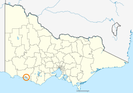
Location in VictoriaPopulation: 33,374(2009)[1] Established: 1855 Area: 120 km² (46.3 sq mi) Mayor: Jacinta Ermacora Council Seat: Warrnambool State District: South-West Coast Federal Division: Wannon 
LGAs around City of Warrnambool: Moyne Moyne Moyne Moyne City of Warrnambool Moyne Southern Ocean Southern Ocean Southern Ocean This article is about a local government area. For the locality, see Warrnambool, Victoria.The City of Warrnambool is a Local Government Area in Victoria, Australia. It is located in the south-western part of the state. The City covers an area of 120.7 square kilometres (46.6 sq mi).
It is one of the few regional councils in Victoria to remain serving just one town after the amalgamation process in 1994, although it gained some portions of the former Shire of Warrnambool. It is wholly surrounded by the Shire of Moyne and the Southern Ocean.
Contents
History
Warrnambool was first incorporated as a municipality on 7 December 1855. It became a borough on 1 October 1863, and a town on 2 February 1883. It was proclaimed as a city on 8 April 1918. On 25 October 1955 and 1 October 1978, it annexed part of the south riding of the Shire of Warrnambool, expanding its area progressively to 34.43 square kilometres (13.29 sq mi) by the time of Victoria's local government amalgamations.[2]
In 1993, the new Kennett Liberal government announced a program of local government reform, in which many of Victoria's 210 councils were to be amalgamated. The southwest region containing 23 councils was the first to be reviewed, and the City of Warrnambool sought to be part of the process early on. Warrnambool's strength in tertiary education and manufacturing was taken into account.[3] By June, it was clear that Warrnambool would be the only municipality in the region to be spared, and that it would gain Allansford and some other rural areas from the Shire of Warrnambool.[4] On 23 September 1994, the council was dismissed and replaced with a Government-appointed commissioner.[5] It first held elections for a new council in March 1996.[6]
Wards and structure
Prior to amalgamation, the council had four wards—Albert, Hopkins, Merri and Victoria—each of which elected three councillors.[2] The new council had seven wards with one councillor representing each ward.
Wards 1996-2004:
- Botanic Ward
- Cassady Ward
- Levy Ward
- Pertobe Ward
- Proudfoot Ward
- Sherwood Ward
- Wollaston Ward
However, following an electoral representation review, the decision was made to keep the seven councillors but abolish wards. The review concluded that Warrnambool's geography and natural features did not support the creation of equal wards, and that the City of Warrnambool as a whole was a single community of interest.[7]
Geography
The City of Warrnambool is dominated by the Warrnambool urban area, which represents 35.0 square kilometres (13.5 sq mi), or 29.0%, of the City's area and at the 2006 census had a population of 28,150.[8]
Other towns within the City's area include:
- Allansford (1,203)
- Bushfield
- Dennington (1,171)
- Illowa
- Woodford
- Yangery
See also
References
- ^ Australian Bureau of Statistics (30 March 2010). "Regional Population Growth, Australia, 2008–09". http://www.abs.gov.au/ausstats/abs@.nsf/Latestproducts/3218.0Main%20Features52008-09?opendocument&tabname=Summary&prodno=3218.0&issue=2008-09&num=&view=. Retrieved 3 June 2010.
- ^ a b Victorian Municipal Directory. Brunswick: Arnall & Jackson. 1992. pp. 518–519. Accessed at State Library of Victoria, La Trobe Reading Room.
- ^ Taylor, Thomas (26 February 1994). "Bush councils in Victoria's southwest face a shakeup". The Age: p. 1.
- ^ Gettler, Leon (17 June 1994). "23 councils become 8 in board's proposal". The Age: p. 7.
- ^ Gettler, Leon (24 September 1994). "Councils merged and rates frozen". The Age: p. 10.
- ^ Australian Bureau of Statistics (1 August 1995) (PDF). Victorian local government amalgamations 1994-1995: Changes to the Australian Standard Geographical Classification. Commonwealth of Australia. p. 11. ISBN 0-642-23117-6. http://www.ausstats.abs.gov.au/ausstats/free.nsf/0/76E601D6DB55E88ACA25722500049195/$File/12570_1994-95.pdf. Retrieved 2008-01-05.
- ^ Victorian Electoral Commission (10 May 2004). "Final Report - Electoral Representation Review - Warrnambool City Council" (PDF). http://www.vec.vic.gov.au/resources/WarrnamboolFinalReport.pdf.
- ^ Australian Bureau of Statistics (25 October 2007). "Warrnambool (Urban Centre/Locality)". 2006 Census QuickStats. http://www.censusdata.abs.gov.au/ABSNavigation/prenav/LocationSearch?collection=Census&period=2006&areacode=UCL256200&producttype=QuickStats&breadcrumb=PL&action=401. Retrieved 2008-03-11. Map
External links
Towns in the City of Warrnambool Allansford · Bushfield · Dennington · Illowa · Warrnambool · Woodford · Yangery
Local Government Areas of Victoria Greater Melbourne Inner MelbourneMetropolitanBanyule · Bayside · Boroondara · Darebin · Glen Eira · Hobsons Bay · Kingston · Maribyrnong · Maroondah · Monash · Moonee Valley · Moreland · WhitehorseOuter MetropolitanBrimbank · Cardinia · Casey · Frankston · Greater Dandenong · Hume · Knox · Manningham · Melton · Mornington Peninsula · Nillumbik · Whittlesea · Wyndham · Yarra RangesSouthwest Central Highlands and Goldfields Goulburn Valley Northeast Gippsland Western District Ararat · Corangamite · Glenelg · Lady Julia Percy Island · Moyne · Pyrenees · Southern Grampians · WarrnamboolWimmera The Mallee Coordinates: 38°28′00″S 142°28′00″E / 38.4666667°S 142.4666667°E
Categories:- Populated places established in 1855
- 1855 establishments in Australia
- Local Government Areas of Victoria (Australia)
- Warrnambool

Wikimedia Foundation. 2010.