- Shire of Mount Alexander
-
Shire of Mount Alexander
Victoria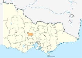
Location in VictoriaPopulation: 18,293(2009)[1] Area: 1529 km² (590.4 sq mi) Mayor: Phillip Schier Council Seat: Castlemaine 
LGAs around Shire of Mount Alexander: Loddon Greater Bendigo Greater Bendigo Central Goldfields Shire of Mount Alexander Mitchell Hepburn Hepburn Macedon Ranges The Shire of Mount Alexander is a Local Government Area in Victoria, Australia. It is located in the central part of the state. The largest town is Castlemaine. Other towns within the shire include: Maldon, Newstead, Harcourt and Taradale. Small villages within the shire include: Vaughan, Fryerstown and Campbells Creek. It was formed in 1995 from the merger of the City of Castlemaine, Shire of Newstead, and most of the Shire of Maldon and Shire of Metcalfe.
It has an area of 1,531 square kilometres and in 2006 it had a population of 17,066.
Contents
Wards
Mount Alexander Shire is divided into five wards:
- Calder Ward
- Castlemaine Ward
- Coliban Ward
- Loddon Ward
- Tarrengower Ward
Castemaine Ward has three councillors while the other wards are represented by one councillor each.[2]
See also
References
- ^ Australian Bureau of Statistics (30 March 2010). "Regional Population Growth, Australia, 2008–09". http://www.abs.gov.au/ausstats/abs@.nsf/Latestproducts/3218.0Main%20Features52008-09?opendocument&tabname=Summary&prodno=3218.0&issue=2008-09&num=&view=. Retrieved 3 June 2010.
- ^ "Mount Alexander Shire Council". Victorian Electoral Commission. http://www.vec.vic.gov.au/MountAlexanderHome.html. Retrieved 2008-01-17.
External links
- Mount Alexander Shire Council official website
- Metlink local public transport map
- Link to Land Victoria interactive maps
Cities, towns and localities in the Shire of Mount Alexander Cities: Townships: Barfold · Baringhup · Baringhup West · Barkers Creek · Bradford · Campbells Creek · Chewton · Elphinstone · Faraday · Fryerstown · Glenluce · Golden Point · Gower · Green Gully · Guildford · Harcourt · Irishtown · Joyces Creek · Langley · Maldon · McKenzie Hill · Metcalfe · Metcalfe East · Moonlight Flat · Muckleford · Muckleford South · Myrtle Creek · Neereman · Newstead · Nuggetty · Ravenswood South · Redesdale · Sandon · Strangways · Strathlea · Sutton Grange · Taradale · Tarilta · Tarrengower · Vaughan · Walmer · Welshmans Reef · Werona · Yandoit Hills · Yapeen
Local Government Areas of Victoria Greater Melbourne Inner MelbourneMetropolitanBanyule · Bayside · Boroondara · Darebin · Glen Eira · Hobsons Bay · Kingston · Maribyrnong · Maroondah · Monash · Moonee Valley · Moreland · WhitehorseOuter MetropolitanBrimbank · Cardinia · Casey · Frankston · Greater Dandenong · Hume · Knox · Manningham · Melton · Mornington Peninsula · Nillumbik · Whittlesea · Wyndham · Yarra RangesSouthwest Central Highlands and Goldfields Ballarat · Central Goldfields · Greater Bendigo · Hepburn · Loddon · Macedon Ranges · Mitchell · Moorabool · Mount AlexanderGoulburn Valley Northeast Gippsland Western District Wimmera The Mallee Coordinates: 37°04′00″S 144°13′00″E / 37.0666667°S 144.2166667°E
Categories:- Local Government Areas of Victoria (Australia)
- Australia government stubs

Wikimedia Foundation. 2010.