- Oakridge, Toronto
-
Not to be confused with Oak Ridges, Ontario.
Oakridge — Neighbourhood — Houses in Oakridge Vicinity
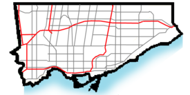
 Location within Toronto
Coordinates: 43°41′44″N 79°16′33″W / 43.69556°N 79.27583°WCoordinates: 43°41′44″N 79°16′33″W / 43.69556°N 79.27583°W Country  Canada
Province  Ontario
City  Toronto
Community Scarborough Changed Municipality 1998 Toronto from  Scarborough
Government - MP Dan Harris (Scarborough Southwest) - MPP Lorenzo Berardinetti (Scarborough Southwest) - Councillor Michelle Berardinetti (Ward 35 Scarborough Centre) Oakridge is a neighbourhood in the city of Toronto, in the Scarborough district. The neighbourhood is bordered by Victoria Park Avenue to the West, Massey Creek to the North, Warden Avenue to the East travelling South until Mack Avenue which then extends East again to the CNR rail line which forms the Southern Border.
The section of the Danforth running through Oakridge provides its residence with shopping, dining and other entertainment. The Oakridge Community Centre is also where many of the youth in the neighbourhood find their entertainment. The Bloor-Danforth subway line of the TTC runs through the Warden Woods park, and both the Warden and Victoria Park stations are located within the community.
There is public housing in the neighbourhood including Cataraqui Crescent/Firvalley Court and Teesdale Place.
This is a working class neighbourhood, which is very diverse ethnically, religiously and even the types of homes you will see. An indication of this diversity can be seen by the fact that over 40% of residents are Black or South Asian and over 20% of residents are of the Muslim faith. Languages such as Bengali, Urdu and Tamil are spoken in this area which further cements Oakridge as another in a collection of very diverse neighbourhoods in Toronto.
See also
External links

Clairlea East Danforth (Toronto) 
Cliffside  Oakridge

Birch Cliff Categories:- Neighbourhoods in Toronto


Wikimedia Foundation. 2010.