- Coffee County, Alabama
-
Coffee County, Alabama 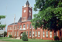
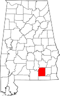
Location in the state of Alabama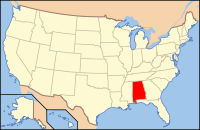
Alabama's location in the U.S.Founded Formed from western Dale County 1841 Seat Elba Largest city Enterprise Area
- Total
- Land
- Water
680.48 sq mi (1,762 km²)
678.99 sq mi (1,759 km²)
1.49 sq mi (4 km²), (0.22%)Population
- (2010)
- Density
49,948
73/sq mi (28.3/km²)Website www.coffeecounty.us Coffee County is a county of the U.S. state of Alabama. Its name is in honor of General John Coffee. As of 2010 the population was 49,948. Its county seats are Elba and Enterprise.
Coffee County is part of the Enterprise–Ozark Micropolitan Statistical Area.
Contents
History
The land in Coffee County was originally part of Dale County, which was incorporated in 1824. Coffee County was formed from the western part of Dale County in 1841. It was named after John R. Coffee, a hero in the Creek War of 1813—14. The first county seat was in Wellborn. After the courthouse was destroyed by fire in 1851, the county seat was moved to Elba.
Geography
According to the 2000 census, the county has a total area of 680.48 square miles (1,762.4 km2), of which 678.99 square miles (1,758.6 km2) (or 99.78%) is land and 1.49 square miles (3.9 km2) (or 0.22%) is water.[1]
Major highways
 U.S. Highway 84
 State Route 27
 State Route 51
 State Route 87
 State Route 88
 State Route 92
 State Route 134
Adjacent counties
- Pike County (north)
- Dale County (east)
- Geneva County (south)
- Covington County (west)
- Crenshaw County (northwest)
Demographics
Coffee County, Alabama Year Pop. ±% 1850 5,940 — 1860 9,623 +62.0% 1870 6,171 −35.9% 1880 8,119 +31.6% 1890 12,170 +49.9% 1900 20,972 +72.3% 1910 26,119 +24.5% 1920 30,070 +15.1% 1930 32,556 +8.3% 1940 31,987 −1.7% 1950 30,720 −4.0% 1960 30,583 −0.4% 1970 34,872 +14.0% 1980 38,533 +10.5% 1990 40,240 +4.4% 2000 43,615 +8.4% 2010 49,948 +14.5% Sources: "American FactFinder". United States Census Bureau. http://factfinder2.census.gov/faces/nav/jsf/pages/index.xhtml. through 1960 As of the census[2] of 2000, there were 43,615 people, 17,421 households, and 12,490 families residing in the county. The population density was 64 people per square mile (25/km2). There were 19,837 housing units at an average density of 29 per square mile (11/km2). The racial makeup of the county was 77.11% White, 18.37% Black or African American, 0.91% Native American, 0.95% Asian, 0.09% Pacific Islander, 0.89% from other races, and 1.67% from two or more races. 2.71% of the population were Hispanic or Latino of any race.
There were 17,421 households out of which 32.10% had children under the age of 18 living with them, 56.40% were married couples living together, 12.10% had a female householder with no husband present, and 28.30% were non-families. 24.90% of all households were made up of individuals and 10.20% had someone living alone who was 65 years of age or older. The average household size was 2.46 and the average family size was 2.93.
In the county the population was spread out with 24.80% under the age of 18, 8.90% from 18 to 24, 28.10% from 25 to 44, 24.10% from 45 to 64, and 14.10% who were 65 years of age or older. The median age was 37 years. For every 100 females there were 95.50 males. For every 100 females age 18 and over, there were 92.00 males.
The median income for a household in the county was $33,664, and the median income for a family was $39,664. Males had a median income of $31,468 versus $20,234 for females. The per capita income for the county was $18,321. About 11.30% of families and 14.70% of the population were below the poverty line, including 22.30% of those under age 18 and 13.50% of those age 65 or over.
Cities and towns
- Elba
- Enterprise (part - part of Enterprise is in Dale County)
- Kinston
- New Brockton
Unincorporated communities
- Alberton
- Basin
- Battens Crossroads
- Bluff Springs
- Brooklyn
- Central City
- Chesnut Grove
- Clintonville
- Clowers Crossroads
- Coppinville
- Curtis
- Damascus
- Danleys Crossroads
- Frisco
- Goodman
- Ino
- Jack
- Java
- Keyton
- Lowry Mill
- Newby
- Perry Store
- Pine Level
- Rhoades
- Richburg
- Roeton
- Shady Grove
- Tabernacle
- Turner Crossroads
- Victoria
- Wilkinstown
- Zoar
Notable people
- Coffee County is home to "The Dancing Ghost" of Grancer Harrison, featured in the book 13 Alabama Ghosts and Jeffrey.
In popular culture
The county is referred to in Joe David Brown's 1971 novel Addie Pray, which inspired the movie Paper Moon.
See also
- National Register of Historic Places listings in Coffee County, Alabama
- Properties on the Alabama Register of Landmarks and Heritage in Coffee County, Alabama
References
- ^ "Census 2000 U.S. Gazetteer Files: Counties". United States Census. http://www.census.gov/tiger/tms/gazetteer/county2k.txt. Retrieved 2011-02-13.
- ^ "American FactFinder". United States Census Bureau. http://factfinder.census.gov. Retrieved 2008-01-31.
External links
Coordinates: 31°24′12″N 85°59′12″W / 31.40333°N 85.98667°W

Crenshaw County Pike County Covington County 
Dale County  Coffee County, Alabama

Geneva County Municipalities and communities of Coffee County, Alabama Cities Elba | Enterprise‡

Towns Footnotes ‡This populated place also has portions in an adjacent county or counties
 State of Alabama
Topics - Index
- History
- Geography
- People
- Delegations
- Government
- Governors
- Lieutenant Governors
- Metropolitan Areas
- Visitor Attractions
- National Historic Landmarks
Regions Metros - Greater Birmingham
- Montgomery Metro Area
- Mobile Metro Area
- Huntsville Metro Area
Larger cities Counties - Autauga
- Baldwin
- Barbour
- Bibb
- Blount
- Bullock
- Butler
- Calhoun
- Chambers
- Cherokee
- Chilton
- Choctaw
- Clarke
- Clay
- Cleburne
- Coffee
- Colbert
- Conecuh
- Coosa
- Covington
- Crenshaw
- Cullman
- Dale
- Dallas
- DeKalb
- Elmore
- Escambia
- Etowah
- Fayette
- Franklin
- Geneva
- Greene
- Hale
- Henry
- Houston
- Jackson
- Jefferson
- Lamar
- Lauderdale
- Lawrence
- Lee
- Limestone
- Lowndes
- Macon
- Madison
- Marengo
- Marion
- Marshall
- Mobile
- Monroe
- Montgomery
- Morgan
- Perry
- Pickens
- Pike
- Randolph
- Russell
- Shelby
- St. Clair
- Sumter
- Talladega
- Tallapoosa
- Tuscaloosa
- Walker
- Washington
- Wilcox
- Winston
Categories:- Alabama counties
- Coffee County, Alabama
- Enterprise-Ozark micropolitan area
- 1841 establishments in the United States
- Populated places established in 1841


Wikimedia Foundation. 2010.