- Garland County, Arkansas
-
Garland County, Arkansas 
Location in the state of Arkansas
Arkansas's location in the U.S.Founded April 5, 1873 Seat Hot Springs Area
- Total
- Land
- Water
734.57 sq mi (1,903 km²)
677.22 sq mi (1,754 km²)
57.35 sq mi (149 km²), 7.81%Population
- (2010)
- Density
96,024
142/sq mi (54.74/km²)Garland County is a county located in the U.S. state of Arkansas. As of the 2010 census, the population was 96,024. The county seat is Hot Springs.[1] Garland County is Arkansas's 68th county, formed on April 5, 1873, and named for Augustus Garland, eleventh governor of Arkansas. The county is coextensive with the Hot Springs Metropolitan Statistical Area, which includes Hot Springs National Park.
Contents
Geography
According to the 2000 census, the county has a total area of 734.57 square miles (1,902.5 km2), of which 677.22 square miles (1,754.0 km2) (or 92.19%) is land and 57.35 square miles (148.5 km2) (or 7.81%) is water.[2]
Major highways
 U.S. Highway 70
 U.S. Highway 270
 Highway 5
 Highway 7
 Highway 88
Adjacent counties
- Perry County (north)
- Saline County (east)
- Hot Spring County (south)
- Montgomery County (west)
- Yell County (northwest)
National protected areas
Demographics
Historical populations Census Pop. %± 1880 9,023 — 1890 15,328 69.9% 1900 18,773 22.5% 1910 27,271 45.3% 1920 25,785 −5.4% 1930 36,031 39.7% 1940 41,664 15.6% 1950 47,102 13.1% 1960 46,697 −0.9% 1970 54,131 15.9% 1980 70,531 30.3% 1990 73,397 4.1% 2000 88,068 20.0% 2010 96,024 9.0% [3][4][5]  Age pyramid Garland County[6]
As of the census[7] of 2000, there were 88,068 people, 37,813 households, and 25,259 families residing in the county. The population density was 130 people per square mile (50/km²). There were 44,953 housing units at an average density of 66 per square mile (26/km²). The racial makeup of the county was 88.85% White, 7.80% Black or African American, 0.61% Native American, 0.50% Asian, 0.03% Pacific Islander, 0.72% from other races, and 1.49% from two or more races. 2.56% of the population were Hispanic or Latino of any race.
There were 37,813 households out of which 25.10% had children under the age of 18 living with them, 53.20% were married couples living together, 10.10% had a female householder with no husband present, and 33.20% were non-families. 28.80% of all households were made up of individuals and 13.50% had someone living alone who was 65 years of age or older. The average household size was 2.28 and the average family size was 2.78.
In the county the population was spread out with 21.30% under the age of 18, 7.30% from 18 to 24, 25.20% from 25 to 44, 25.10% from 45 to 64, and 21.20% who were 65 years of age or older. The median age was 42 years. For every 100 females there were 94.40 males. For every 100 females age 18 and over, there were 90.80 males.
The median income for a household in the county was $31,724, and the median income for a family was $38,079. Males had a median income of $28,117 versus $20,421 for females. The per capita income for the county was $18,631. About 10.50% of families and 14.60% of the population were below the poverty line, including 22.70% of those under age 18 and 8.60% of those age 65 or over.
Communities
Cities Towns CDPs Other
communityTownships
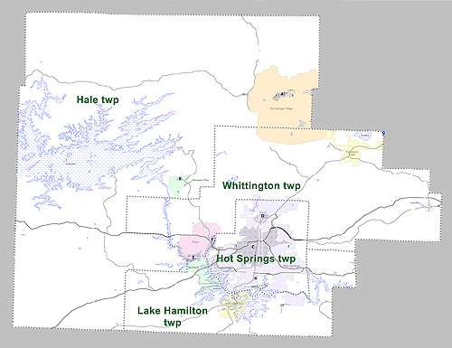
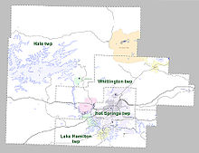 Townships in Garland County, Arkansas as of 2010
Townships in Arkansas are the divisions of a county. Each township includes unincorporated areas and some may have incorporated towns or cities within part of their space. Townships have limited purposes in modern times. However, the US Census does list Arkansas population based on townships (often referred to as "minor civil divisions"). Townships are also of value for historical purposes in terms of genealogical research. Each town or city is within one or more townships in an Arkansas county based on census maps. The townships of Garland County are listed below with the town(s) and/or city that are fully or partially inside them listed in parentheses. [8][9]
- Hale (Mountain Pine, most of Census Designated Place Hot Springs Village, small part of CDP Rockwell)
- Hot Springs (most of Hot Springs)
- Lake Hamilton (CDP Lake Hamilton, most of CDP Rockwell)
- Whittington (Fountain Lake, Lonsdale, CDP Piney, part of CDP Hot Springs Village, small part of Hot Springs)
See also
References
- ^ "Find a County". National Association of Counties. http://www.naco.org/Counties/Pages/FindACounty.aspx. Retrieved 2011-06-07.
- ^ "Census 2000 U.S. Gazetteer Files: Counties". United States Census. http://www.census.gov/tiger/tms/gazetteer/county2k.txt. Retrieved 2011-02-13.
- ^ http://www.census.gov/population/www/censusdata/cencounts/files/ar190090.txt
- ^ http://factfinder2.census.gov
- ^ http://mapserver.lib.virginia.edu/
- ^ Based on 2000 census data
- ^ "American FactFinder". United States Census Bureau. http://factfinder.census.gov. Retrieved 2008-01-31.
- ^ US Census Bureau. 2011 Boundary and Annexation Survey (BAS): Garland County, AR (Map). http://www2.census.gov/geo/pvs/bas/bas11/st05_ar/cou/c05051_garland/BAS11C20505100000_000.pdf. Retrieved 20110814.
- ^ http://www.census.gov/geo/www/maps/DC10_GUBlkMap/cousub/dc10blk_st05_cousub.html#G
External links
- Garland County government's website
- Hot Springs, Arkansas Community Guides • What to do and where to find it in Hot Springs, Arkansas.

Yell County Perry County Montgomery County 
Saline County  Garland County, Arkansas

Hot Spring County Municipalities and communities of Garland County, Arkansas County seat: Hot Springs Cities 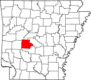
Towns CDPs Hot Springs Village‡ | Lake Hamilton | Piney | Rockwell
Unincorporated
communitiesBuckville | Jessieville | Pearcy | Royal | Shorewood Hills | Sunshine
Footnotes ‡This populated place also has portions in an adjacent county or counties
Categories:- Arkansas counties
- Garland County, Arkansas
- 1873 establishments


Wikimedia Foundation. 2010.