- Benton County, Arkansas
-
Benton County, Arkansas 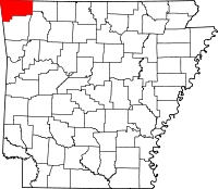
Location in the state of Arkansas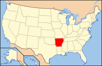
Arkansas's location in the U.S.Founded 30 September 1836 Seat Bentonville Largest city Rogers Area
- Total
- Land
- Water
880.24 sq mi (2,280 km²)
845.99 sq mi (2,191 km²)
34.25 sq mi (89 km²), 3.89%Population
- (2010)
- Density
221,339
262/sq mi (101/km²)Website www.co.benton.ar.us Benton County is a county located in the U.S. state of Arkansas. As of the 2000 census, the population was 153,406. The U.S. Census Bureau 2010 population is 221,339.[1] The county seat is Bentonville.[2] Benton County was formed on 30 September 1836 and was named after Thomas Hart Benton, a U.S. Senator from Missouri. It is a dry county; alcohol sales are prohibited, except in establishments with a private club liquor license.
Benton County is part of the Fayetteville–Springdale–Rogers, AR-MO Metropolitan Statistical Area.
Contents
Geography
According to the 2000 census, the county has a total area of 880.24 square miles (2,279.8 km2), of which 845.99 square miles (2,191.1 km2) (or 96.11%) is land and 34.25 square miles (88.7 km2) (or 3.89%) is water.[3] Most of the water is in Beaver Lake.
Transportation
 Interstate 540
 U.S. Highway 62
 U.S. Highway 71
 U.S. Highway 412
 Highway 12
 Highway 16
 Highway 43
 Highway 59
 Highway 72
 Highway 94
 Highway 102
The Northwest Arkansas Regional Airport is located near Highfill.
The Arkansas and Missouri Railroad parallels US Highways 62 and 71 in the county.
The historic Trail of Tears is on US highways 62 and 71, connects with another US route 412 in nearby Washington County.
Adjacent counties
- Barry County, Missouri (north)
- Carroll County (east)
- Madison County (southeast)
- Washington County (south)
- Adair County, Oklahoma (southwest)
- Delaware County, Oklahoma (west)
- McDonald County, Missouri (northwest)
National protected areas
- Logan Cave National Wildlife Refuge
- Ozark National Forest (part)
- Pea Ridge National Military Park
Demographics
Historical populations Census Pop. %± 1840 2,228 — 1850 3,710 66.5% 1860 9,306 150.8% 1870 13,831 48.6% 1880 20,328 47.0% 1890 27,716 36.3% 1900 31,611 14.1% 1910 33,389 5.6% 1920 36,253 8.6% 1930 35,253 −2.8% 1940 36,148 2.5% 1950 38,076 5.3% 1960 36,272 −4.7% 1970 50,476 39.2% 1980 78,115 54.8% 1990 97,499 24.8% 2000 153,406 57.3% 2010 221,339 44.3% [4][5][6] 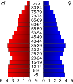 Age pyramid Benton County[7]
As of the census[8] of 2000, there were 153,406 people, 58,212 households, and 43,484 families residing in the county. The population density was 181 people per square mile (70/km²). There were 64,281 housing units at an average density of 76 per square mile (29/km²). The racial makeup of the county was 90.87% White, 0.41% Black or African American, 1.65% Native American, 1.09% Asian, 0.08% Pacific Islander, 4.08% from other races, and 1.82% from two or more races. 8.78% of the population were Hispanic or Latino of any race.
As of 2005 Benton County's population was 81.7% non-Hispanic white, while the percentage of Latinos grew by 60 percent in the time period. Latinos are attracted to the growth of light industrial jobs, home construction and service sector in the county. 1.1% of the population was African-American (perhaps the lowest in all of Arkansas); 1.6% was Native American (the historical presence of the Cherokee Indians live in close proximity to Oklahoma); 1.7% was Asian (there was a large influx of Filipinos, Vietnamese and South Asian immigrants arrived in recent decades) and 0.2% of the population was Pacific Islander. 1.6% reported two or more races, usually not black-white due to a minuscule African-American population. And 12.8% was Latino, but the United States Hispanic Chamber of Commerce believed the official estimate is underreported and Latinos could well be 20 percent of the population.[9]
There were 58,212 households out of which 34.40% had children under the age of 18 living with them, 63.00% were married couples living together, 8.20% had a female householder with no husband present, and 25.30% were non-families. 21.10% of all households were made up of individuals and 8.50% had someone living alone who was 65 years of age or older. The average household size was 2.60 and the average family size was 3.01.
In the county the population was spread out with 26.60% under the age of 18, 8.60% from 18 to 24, 29.40% from 25 to 44, 21.10% from 45 to 64, and 14.30% who were 65 years of age or older. The median age was 35 years. For every 100 females there were 97.40 males. For every 100 females age 18 and over, there were 94.90 males.
The median income for a household in the county was $40,281, and the median income for a family was $45,235. Males had a median income of $30,327 versus $22,469 for females. The per capita income for the county was $19,377. About 7.30% of families and 10.10% of the population were below the poverty line, including 13.80% of those under age 18 and 7.30% of those age 65 or over.
As of census 2010 the county population was 221,339. The racial makeup of the county was 76.18% Non-Hispanic white, 1.27% black, 1.69% Native American, 2.85% Asian, 0.30% Pacific Islander, 0.10% Non-Hispanics of some other race, 1.93% Non-Hispanics reporting two or more races and 15.49% Hispanic or Latino.
Benton County Corporations
- Wal-Mart corporate headquarters is located in Bentonville.
- Daisy Outdoor Products, known for its air rifles, is headquartered in Rogers.
- JB Hunt Transport Services corporate headquarters is located in Lowell.
- Tyson Foods, based in nearby Springdale, has a distribution center located in Rogers.
Cities and towns
- Siloam Springs
- Springdale (mostly in Washington County)
- Springtown
- Sulphur Springs
- War Eagle
Census Designated Places (CDPs)
- Hiwasse
- Lost Bridge Village
Townships
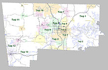 Townships in Benton County, Arkansas as of 2010
Note: Most Arkansas counties have names for their townships. Benton County, however, has numbers instead of names.
Townships in Arkansas are the divisions of a county. Each township includes unincorporated areas and some may have incorporated towns or cities within part of their space. Townships have limited purposes in modern times. However, the US Census does list Arkansas population based on townships (often referred to as "minor civil divisions"). Townships are also of value for historical purposes in terms of genealogical research. Each town or city is within one or more townships in an Arkansas county based on census maps. The townships of Benton County are listed below with the town(s) and/or city that are fully or partially inside them listed in parentheses. [10][11]
- Twp 1 (all of the following: Garfield, Gateway, Lost Bridge Village, Prairie Creek; parts of the following: Avoca, Rogers)
- Twp 2 (small parts of the following: Lowell, Rogers, Springdale)
- Twp 3 (parts of the following: Lowell, Rogers, Springdale; most of Bethel Heights)
- Twp 4 (all of Cave Springs ; most of the following: Lowell, Rogers, Springdale (within Benton County); small parts of Elm Springs)
- Twp 5 (part of Rogers)
- Twp 6 (most of Little Flock; almost half of Avoca; small parts of Bentonville, Pea Ridge, Rogers)
- Twp 7 (most of Pea Ridge; part of Bella Vista; small part of Bentonville)
- Twp 8 (part of Bentonville)
- Twp 9 (most of the following: Bentonville, Centerton; small part of Highfill)
- Twp 10 (most of the following: Bella Vista, Hiwasse)
- Twp 11 (all of the following: Cherokee City, Decatur, [Gravette, Arkansas|Gravette]], [Maysville, Arkansas|Maysville]], Sulphur Springs; small parts of the following: Centerton, Highfill, Hiwasse)
- Twp 12 (most of Gentry; more than half of Siloam Springs;
- Twp 13 (all of Springtown; most of Highfill; small parts of the following: Elm Springs, Gentry, Springdale)
See also
References
- ^ Benton County, Arkansas - Population Finder - American FactFinder
- ^ "Find a County". National Association of Counties. http://www.naco.org/Counties/Pages/FindACounty.aspx. Retrieved 2011-06-07.
- ^ "Census 2000 U.S. Gazetteer Files: Counties". United States Census. http://www.census.gov/tiger/tms/gazetteer/county2k.txt. Retrieved 2011-02-13.
- ^ http://www.census.gov/population/www/censusdata/cencounts/files/ar190090.txt
- ^ http://factfinder2.census.gov
- ^ http://mapserver.lib.virginia.edu/
- ^ Based on 2000 census data
- ^ "American FactFinder". United States Census Bureau. http://factfinder.census.gov. Retrieved 2008-01-31.
- ^ Benton County QuickFacts from the US Census Bureau
- ^ US Census Bureau. 2011 Boundary and Annexation Survey (BAS): Benton County, AR (Map). http://www2.census.gov/geo/pvs/bas/bas11/st05_ar/cou/c05007_benton/BAS11C20500700000_000.pdf. Retrieved 20110808.
- ^ http://www.census.gov/geo/www/maps/DC10_GUBlkMap/cousub/dc10blk_st05_cousub.html#B
External links

McDonald County, Missouri Barry County, Missouri Delaware County, Oklahoma 
Carroll County  Benton County, Arkansas

Adair County, Oklahoma Washington County Madison County Municipalities and communities of Benton County, Arkansas Cities Bentonville | Bethel Heights | Cave Springs | Centerton | Decatur | Elm Springs‡ | Gentry | Gravette | Little Flock | Lowell | Pea Ridge | Rogers | Siloam Springs | Springdale‡ | Sulphur Springs

Towns Avoca | Bella Vista | Garfield | Gateway | Highfill | Springtown
Townships 1 | 2 | 3 | 4 | 5 | 6 | 7 | 8 | 9 | 10 | 11 | 12 | 13
CDPs Cherokee City | Hiwasse | Lost Bridge Village | Maysville | Prairie Creek
Other
communitiesAccident | Apple Spur | Beacon Addition | Beaty | Beaver Shores | Bella Vista | Benton City | Blackjack Corner | Bland | Bloomfield | Brightwater | Clantonville | Clear Point | Creech | Cross Hollow | Dawn Hill | Dug Hill | Eagle Corner | Elkhorn Tavern | Fairmount | Falling Springs | Frisco | Gallatin | Glade | Green Acres | Healing Springs | Hickory Creek | Hico | Hill Top | Ionia | Lake Frances | Lakeland Hills | Larue | Leetown | Logan | Martin | Mason Valley | Miller | Monte Ne | Nebo | Norwood | Oak Grove | Osage Mills | Pedro | Pine Top | Pleasant Hill | Pleasant Ridge | Pleasure Heights | Rago | Rambo Riveria | Rivercliff Estates | Robinson | Rocky Comfort | Seba | Silent Grove | Spring Creek | Tanglewood | Twin Springs | Vaughn | Vista Shores | Walnut Hill | War Eagle | West Point
Ghost town Footnotes ‡This populated place also has portions in an adjacent county or counties
 State of Arkansas
Topics - Index
- Arkansans
- Constitution
- Delegations
- Geography
- Government
- Governor (List)
- History
- Images
- Places
- Transportation
- Visitor Attractions
Society - Culture
- Crime
- Demographics
- Economy
- Education
- Politics
Regions Metros Largest cities Other cities Counties - Arkansas
- Ashley
- Baxter
- Benton
- Boone
- Bradley
- Calhoun
- Carroll
- Chicot
- Clark
- Clay
- Cleburne
- Cleveland
- Columbia
- Conway
- Craighead
- Crawford
- Crittenden
- Cross
- Dallas
- Desha
- Drew
- Faulkner
- Franklin
- Fulton
- Garland
- Grant
- Greene
- Hempstead
- Hot Spring
- Howard
- Independence
- Izard
- Jackson
- Jefferson
- Johnson
- Lafayette
- Lawrence
- Lee
- Lincoln
- Little River
- Logan
- Lonoke
- Madison
- Marion
- Miller
- Mississippi
- Monroe
- Montgomery
- Nevada
- Newton
- Ouachita
- Perry
- Phillips
- Pike
- Poinsett
- Polk
- Pope
- Prairie
- Pulaski
- Randolph
- Saline
- Scott
- Searcy
- Sebastian
- Sevier
- Sharp
- St. Francis
- Stone
- Union
- Van Buren
- Washington
- White
- Woodruff
- Yell
Coordinates: 36°21′08″N 94°14′03″W / 36.35222°N 94.23417°W
Categories:- Arkansas counties
- Benton County, Arkansas
- Fayetteville–Springdale–Rogers metropolitan area
- 1836 establishments in the United States
- Populated places established in 1836


Wikimedia Foundation. 2010.