- Martainville-Épreville
-
Martainville-Épreville
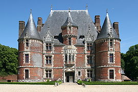
Martainville Château 
 Martainville-ÉprevilleLocation within Upper Normandy region
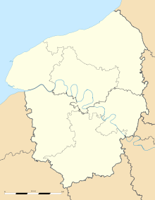 Martainville-Épreville
Administration Country France Region Upper Normandy Department Seine-Maritime Arrondissement Rouen Canton Darnétal Mayor Lionel Saillard
(2001–2014)Statistics Elevation 138–162 m (453–531 ft)
(avg. 152 m/499 ft)Land area1 7.61 km2 (2.94 sq mi) Population2 694 (2006) - Density 91 /km2 (240 /sq mi) INSEE/Postal code 76412/ 76116 1 French Land Register data, which excludes lakes, ponds, glaciers > 1 km² (0.386 sq mi or 247 acres) and river estuaries. 2 Population without double counting: residents of multiple communes (e.g., students and military personnel) only counted once. Coordinates: 49°27′38″N 1°17′31″E / 49.4605555556°N 1.29194444444°E
Martainville-Épreville is a commune in the Seine-Maritime department in the Haute-Normandie region in northern France.
Contents
Geography
A farming village, with some associated light industry, situated some 12 miles (19 km) east of Rouen at the junction of the D85, D13 and the N31 roads.
Heraldry
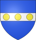
The arms of Martainville-Épreville are blazoned :
Argent, on a fess azure, 3 bezants [Or].Population
Population history 1962 1968 1975 1982 1990 1999 2006 389 438 515 599 606 611 694 Starting in 1962: Population without duplicates Places of interest
 Martainville Château
- The fifteenth century château, with its dovecote, gardens and a museum.
- The churches of St.Ouen and of Notre-Dame, both dating from the seventeenth century.
See also
References
External links
Categories:- Communes of Seine-Maritime
- Rouen geography stubs


Wikimedia Foundation. 2010.