- Mount Warrigal, New South Wales
-
Mount Warrigal
Wollongong, New South Wales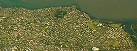
Aerial view from eastPopulation: 5,181 Postcode: 2528 Coordinates: 34°32.8′S 150°50.6′E / 34.5467°S 150.8433°ECoordinates: 34°32.8′S 150°50.6′E / 34.5467°S 150.8433°E LGA: City of Shellharbour State District: Shellharbour Federal Division: Throsby Suburbs around Mount Warrigal: Lake Illawarra Lake Illawarra Lake Illawarra Lake Illawarra Mount Warrigal Warilla Oak Flats Barrack Heights Warilla Mount Warrigal is a large suburb of Wollongong, New South Wales, Australia. The population, according to the 2006 Australian Census, was 5,181.[1] The suburb is in the Shellharbour City LGA.
Contents
Geography
The suburb includes 'Native Dog Hill' and its surrounding areas. To the north and west are the shores of Lake Illawarra. With its high elevation above the surrounding areas and close proximity to the lake, the suburb has excellent views of the Pacific Ocean to the east, Lake Illawarra and the Illawarra Escarpment to both the north and west, and Blackbutt Reserve to the south.
Neighbouring suburbs include Lake Illawarra, Warilla, Barrack Heights and Oak Flats.
Facilities
Shellharbour Hospital is located in Madigan Boulevard, Mount Warrigal. Mount Warrigal also has two small shopping complexes and many public reserves, including Freeman Park which is the only dedicated sporting field. The Stockland Shellharbour shopping centre is in close proximity to the suburb.
At the top of the hill is the Mt Warrigal Nursing Home.
Education
Lake Illawarra High School is on the suburb's north east boundary. The suburb has a primary school, Mount Warrigal Public School established in 1967.
References
External links
Suburbs and Localities of Wollongong, New South Wales Albion Park · Albion Park Rail · Austinmer · Avon · Avondale · Balarang · Balgownie · Barrack Heights · Barrack Point · Bellambi · Berkeley · Blackbutt · Bombo · Broughton Village · Brownsville · Bulli · Burning Palms · Calderwood · Carrington Falls · Cleveland · Clifton · Coalcliff · Coledale · Coniston · Cordeaux · Cordeaux Heights · Corrimal · Cringila · Croom · Curramore · Dapto · Darkes Forest · Dombarton · Dunmore · East Corrimal · Fairy Meadow · Farmborough Heights · Fernhill · Figtree · Flinders · Foxground · Gerringong · Gerroa · Gwynneville · Haywards Bay · Helensburgh · Horsley · Huntley · Jamberoo · Jerrara · Kanahooka · Keiraville · Kembla Grange · Kembla Heights · Kemblawarra · Kiama · Kiama Downs · Kiama Heights · Knights Hill · Koonawarra · Lake Heights · Lake Illawarra · Lilyvale · Macquarie Pass · Maddens Plains · Mangerton · Marshall Mount · Minnamurra · Mount Keira · Mount Kembla · Mount Ousley · Mount Pleasant · Mount Saint Thomas · Mount Warrigal · North Macquarie · North Wollongong · Oak Flats · Otford · Penrose · Port Kembla · Primbee · Rose Valley · Russell Vale · Saddleback Mountain · Scarborough · Shell Cove · Shellharbour · Shellharbour City Centre · Spring Hill · Stanwell Park · Stanwell Tops · Tarrawanna · Thirroul · Tongarra · Toolijooa · Towradgi · Tullimbar · Unanderra · Upper Kangaroo Valley · Warilla · Warrawong · Werri Beach · West Wollongong · Willow Vale · Windang · Wollongong · Wombarra · Wongawilli · Woonona · Yallah · Yellow Rock
Categories:- Shellharbour, New South Wales
- Suburbs of Wollongong, New South Wales

Wikimedia Foundation. 2010.