- Pennsylvania Route 463
-
PA Route 463

Route information Maintained by PennDOT Length: 12.9 mi[2] (21 km) Existed: by 1930[1] – present Major junctions West end:  PA 63 in Hatfield Township
 US 202 / PA 309 in Montgomery Township
East end:  PA 611 in Horsham
Location Counties: Montgomery Highway system Roads in Pennsylvania
Interstate • US • State • Legislative←  PA 462
PA 464  →
→Pennsylvania Route 463 (PA 463) is a 12.9-mile (20.8 km) long route completely in Montgomery County, Pennsylvania. Its western terminus is at PA 63 (Welsh Road) in Hatfield Township and its eastern terminus is at PA 611 in Horsham. It runs through the northern suburban areas of Philadelphia and passes through the towns of Hatfield, Montgomeryville, and Horsham. The route intersects U.S. Route 202 (US 202) and PA 309 in Montgomeryville and PA 152 in Prospectville. Through its length, the route carries the names Forty Foot Road, Cowpath Road, and Horsham Road. PA 463 was designated by 1930 and fully paved by 1940. In 2010, a portion of the route in Montgomery Township was widened.
Contents
Route description
 PA 463 eastbound in Montgomery Township approaching the intersection with Stump Road.
PA 463 begins an intersection with PA 63 on the border of Hatfield Township and Towamencin Township, heading northeast on four-lane undivided Forty Foot Road into Hatfield Township. The road passes through commercial areas and narrows to two lanes before it passes a couple farms. The route continues into residential areas with a few businesses and enters the borough of Hatfield, where it becomes West Broad Street. In Hatfield, the road continues northeast to the center of town. Here, PA 463 turns to the southeast on South Main Street and passes more residential and commercial development, crossing a CSX railroad line. The road crosses back into Hatfield Township becomes Cowpath Road. The route runs through wooded residential neighborhoods before crossing SEPTA's Lansdale/Doylestown Line near the Fortuna station and intersecting Broad Street in a commercial area.[2][3]
Heading back into wooded areas containing homes, PA 463 enters Montgomery Township at the Line Street intersection. It reaches the community of Montgomeryville, where PA 463 widens into a four-lane divided highway and intersects PA 309 (Bethlehem Pike) and US 202 (Doylestown Road) at the Five Points intersection.[2][3]
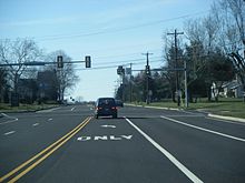 PA 463 westbound in Horsham Township at the intersection with Babylon Road.
Past this intersection, the route takes on the name Horsham Road and passes near more businesses as it narrows into a three-lane road with a center left-turn lane and one travel lane in each direction. After crossing North Wales Road, the route carries five lanes total, with two travel lanes in each direction and a center left-turn lane, as it heads into residential areas. The road passes through commercial areas past the Upper State Road intersection and crosses the 202 Parkway, which is under construction. Past Stump Road, PA 463 narrows to two lanes total and runs past a trailer park to the northeast and business parks to the southwest. The route enters more residential surroundings after intersecting Kenas Road, becoming the border between Horsham Township to the southwest and Montgomery Township to the northeast.[2][3]
Upon crossing Lower State Road, PA 463 fully enters Horsham Township and becomes a three-lane road with a center left-turn lane as it heads past housing subdivisions. The route loses the turning lane and continues southeast to PA 152 in the village of Prospectville. At this intersection, PA 463 gains a center left-turn lane again and passes a few businesses before continuing past Deep Meadow Park and Kohler Park. The road intersects Keith Valley Road and passes near Samuel Carpenter Park along with development. At the Babylon Road junction, the route becomes a five-lane road and runs past more business parks before coming to Privet Road. At this point, PA 463 runs past the Willow Grove Naval Air Station to the northeast. The road passes near some homes before coming to Norristown Road and passing businesses. The route reaches the edge of the naval air station property at the Maple Avenue intersection and continues past more commercial areas. PA 463 intersects Dresher Road, where the center left-turn lane ends and the road becomes four lanes, reaching its eastern terminus at PA 611 in the community of Horsham.[2][3]
History
When Pennsylvania first legislated routes in 1911, present-day PA 463 was not given a number.[4] By 1930, PA 463 was designated onto its current alignment from PA 63 in Hatfield Township to US 611 in Horsham. At this time, the route was paved between PA 63 and Hatfield and within Horsham Township. When first created, PA 463 intersected US 122/US 309 in Montgomery Township, and PA 152 and PA 752 in Horsham Township.[1] The remainder of PA 463 was paved by 1940. Also by this time, US 122 became US 202 and PA 463 no longer intersected PA 752, the first of several changes to the routes that intersected PA 463.[5]
By 1970, the US 309 designation that the route intersected in Montgomeryville became PA 309.[6] The route at the eastern terminus of PA 463 changed from US 611 to PA 611 by 1973.[7] Construction began to widen the section of PA 463 between North Wales Road and General Hancock Boulevard into a five-lane road as part of the 202 Parkway project in 2009.[8] The widening project was completed a year later.[9]
Major intersections
The entire route is in Montgomery County.
Location Mile[2] Destinations Notes Hatfield Township 0.0 PA 63 (Welsh Road, Forty Foot Road)Montgomery Township 5.3 US 202 / PA 309 (Bethlehem Pike, Doylestown Road)Horsham Township 9.2  PA 152 (Limekiln Pike)
12.9 PA 611 (Easton Road)1.000 mi = 1.609 km; 1.000 km = 0.621 mi References
- ^ a b Pennsylvania Department of Highways (1930). Tourist Map of Pennsylvania (Map). ftp://ftp.dot.state.pa.us/public/pdf/BPR_pdf_files/Maps/Statewide/Historic_OTMs/1930fr.pdf. Retrieved January 27, 2011.
- ^ a b c d e f Google, Inc. Google Maps – overview of Pennsylvania Route 463 (Map). Cartography by Google, Inc. http://maps.google.com/maps?f=d&source=s_d&saddr=PA+63+and+PA+463&daddr=PA+463+and+PA+611&hl=en&geocode=FdldZgIdtbeC-ymRZETn9KHGiTEI5goKEbTC5Q%3BFYsXZQIdT5qF-ylnLbwWvq_GiTEX73RLOsN5Jg&mra=ls&sll=40.180815,-75.357365&sspn=0.239219,0.676346&ie=UTF8&t=h&z=12. Retrieved February 10, 2011.
- ^ a b c d ADC Map (2006). Montgomery County, Pennsylvania (Map). 1"=2000' (18th ed.). ISBN 0-87530-775-2.
- ^ Pennsylvania Department of Highways (1911). Map of Pennsylvania Showing State Highways (Map). ftp://ftp.dot.state.pa.us/public/pdf/BPR_pdf_files/Maps/Statewide/Historic_OTMs/1911.pdf. Retrieved January 27, 2011.
- ^ Pennsylvania Department of Highways (1940). Official Road Map of Pennsylvania (Map). ftp://ftp.dot.state.pa.us/public/pdf/BPR_pdf_files/Maps/Statewide/Historic_OTMs/1940fr.pdf. Retrieved June 24, 2010.
- ^ Pennsylvania Department of Highways (1970). Official Map of Pennsylvania (Map). ftp://ftp.dot.state.pa.us/public/pdf/BPR_pdf_files/Maps/Statewide/Historic_OTMs/1970fr.pdf. Retrieved February 10, 2011.
- ^ Exxon (1973). Pennsylvania (Map). Cartography by General Drafting.
- ^ "2009 a year of change for local municipalities". The Reporter (Journal Register Company). January 1, 2010. http://www.thereporteronline.com/articles/2010/01/01/news/srv0000007199595.txt?viewmode=3. Retrieved February 10, 2011.
- ^ Route 202 Parkway Construction Update (December 2010/January 2011 ed.). Pennsylvania Department of Transportation. January 2011. http://www.us202-700.com/pdf/2010.12%202011.01%20202%20Parkway%20Construction%20Update.pdf. Retrieved February 10, 2011.
External links
- Jeff Kitsko's Pennsylvania Highways
- Pennsylvania 463 Junction List
- Adam Prince's State Highway Ends- PA 463
Road transportation infrastructure of the metro Philadelphia area Interstates U.S. Routes Pennsylvania Routes New Jersey Routes Delaware Routes Named roads/streets Benjamin Franklin Parkway · Broad Street · City Avenue · Front Street · Girard Avenue · Market Street · Roosevelt Boulevard · South Street · Chestnut Street · Walnut Street
Pennsylvania Turnpike · New Jersey Turnpike · Delaware Turnpike · Atlantic City Expressway · Schuylkill Expressway · Delaware Expressway · Blue Route · Vine St Expressway · North South Freeway · Lancaster Avenue · Bethlehem Pike · Baltimore Pike · Black Horse PikeBridges Delaware Memorial Bridge · Commodore Barry Bridge · Walt Whitman Bridge · Ben Franklin Bridge · Betsy Ross Bridge · Tacony–Palmyra Bridge · Burlington–Bristol Bridge · Delaware River – Turnpike Toll BridgeCategories:- State highways in Pennsylvania
- Transportation in Montgomery County, Pennsylvania


Wikimedia Foundation. 2010.