- City of Blacktown
-
This article is about the local government area. For the electoral district, see Electoral district of Blacktown. For the suburb, see Blacktown, New South Wales.
City of Blacktown
New South Wales
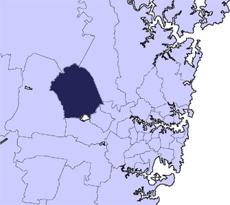
Population: 307,816 (2010) (5th) • Density: 1282.6/km² (3,321.9/sq mi) Area: 240 km² (92.7 sq mi) Mayor: Alan Pendleton Council Seat: Blacktown Region: Metropolitan Sydney State District: Blacktown, Mount Druitt, Riverstone, Londonderry, Smithfield, Toongabbie Federal Division: Chifley, Greenway, McMahon LGAs around City of Blacktown: City of Penrith City of Hawkesbury The Hills Shire City of Penrith City of Blacktown The Hills Shire City of Penrith City of Fairfield City of Holroyd The City of Blacktown is a Local Government Area in the heart of Western Sydney, situated on the Cumberland Plain, approximately 35 km from Sydney CBD. It is bounded by the Local Government Areas (LGAs) of Penrith, Parramatta, Fairfield, Holroyd, Hawkesbury and The Hills Shire. It occupies an area of 246.9 square kilometres. It is the most populous (271,709 - 2006) Local Government Area in New South Wales.
Blacktown was originally named for an Aboriginal settlement in the area. Today, Blacktown continues to be home to a large Aboriginal population, the largest of any suburb or township in New South Wales.
A school for Aborigines was moved in 1823 from Parramatta to the site where Richmond Road meets Rooty Hill Road North. The road from Prospect to Richmond became known as the Black Town Road. In 1860 the Railway Department gave the name of Black Town Road Station to the railway station at the junction of the railway and the Black Town Road, with the name shortening to Blacktown by 1862.
Contents
Suburbs in the local government area
Suburbs in the City of Blacktown are:
Acacia Gardens - Arndell Park - Bidwill - Blackett - Blacktown - Colebee - Dean Park - Dharruk - Doonside - Eastern Creek - Emerton - Glendenning - Glenwood - Hassall Grove - Hebersham - Huntingwood - Kellyville Ridge - Kings Langley - Kings Park - Lalor Park - Lethbridge Park - Marayong - Marsden Park - Minchinbury - Mount Druitt - Oakhurst - Parklea - Plumpton - Prospect - Quakers Hill - Riverstone - Ropes Crossing - Rouse Hill - Rooty Hill - Schofields - Seven Hills - Shalvey - Shanes Park - Stanhope Gardens - The Ponds - Toongabbie - Tregear - Vineyard - Whalan - Willmot - Woodcroft
Politics
Federal Government
At a Federal level, the City of Blacktown encompasses all or parts of the following districts:
Division Member Party affiliation Elected Chifley Ed Husic Labor 2010 Greenway Michelle Rowland Labor 2010 Parramatta Julie Owens Labor 2004 McMahon Chris Bowen Labor 2010 SMD
State Government
The City of Blacktown is within the state of New South Wales. As such it is represented in the New South Wales Legislative Assembly and Legislative Council.
In the Legislative Assembly, the City of Blacktown encompasses all or parts of the following electorates:
Division Member Party affiliation Elected Blacktown John Robertson Labor 2011 Londonderry Bart Bassett Liberal 2011 Mount Druitt Richard Amery Labor 1991 Riverstone Kevin Conolly Liberal 2011 Toongabbie Nathan Rees Labor 2007 Notes
The Electoral District of Wentworthville which previously covered part of the city was dissolved during a redistribution prior to the 2007 election.
Council
Blacktown City Council is composed of fifteen councillors elected proportionally. The city is divided into five wards, each electing three councillors. The mayor is not directly elected.[1] The current makeup of the council is as follows:[1]
Party Councillors Australian Labor Party 8 Liberal Party of Australia 5 Independents 2 Total 15 The current council, elected in 2008, is:[1]
Ward Councillor Party Notes First Ward Alan Pendleton Labor Mayor Nick Tyrrell Liberal Allan Green Independent Second Ward Leo Kelly Labor Len Robinson Liberal Julie Griffiths Labor Third Ward Kathie Collins Labor Jess Diaz Liberal Russ Dickens Independent Fourth Ward Stephen Bali Labor George Bilic Liberal Edmond Atalla Labor Fifth Ward Charlie Lowles Labor Tony Bleasdale Labor Jacqueline Donaldson Liberal Ward Suburbs First *Vineyard, Riverstone, Schofields, Colebee, Dean Park, *Parklea, Acacia Gardens, Stanhope Gardens, Quakers Hill, *Marsden Park, *Rouse Hill, Kellyville Ridge, The Ponds Second * *Blacktown, *Marayong, Kings Langley, Kings Park, Glenwood, Lalor Park, *Seven Hills Third *Doonside, *Blacktown, *Arndell Park, *Huntingwood, *Prospect, *Seven Hills, *Toongabbie Fourth *Tregear, *Hebersham, Whalan, *Doonside, *Blacktown, *Prospect, Eastern Creek, Minchinbury, Rooty Hill, Mount Druitt, *Plumpton, *Glendenning, *Huntingwood, *Arndell Park Fifth *Marsden Park, Shanes Park, Willmot, Shalvey, Bidwill, Hassall Grove, Lethbridge Park, *Tregear, Blackett, Emerton, Dharruk, *Hebersham, Oakhurst, *Plumpton, *Glendenning As of the 2007 social plan, the council has been divided into three regions
North (Glenwood, Stanhope Gardens, Kellyville Ridge, Rouse Hill, The Ponds, Riverstone, Schofields, Parklea, Marsden Park, Shanes Park, Colebee, Quakers Hill, Acacia Gardens, Vineyard)
East (Blacktown, Seven Hills, Lalor Park, Toongabbie, Arndell Park, Kings Langley, Marayong, Kings Park, Huntingwood, Prospect, Doonside)
West (Plumpton, Willmot, Mount Druitt, Rooty Hill, Oakhurst, Tregear, Emerton, Dharruk, Hebersham, Glendenning, Dean Park, Whalan, Minchinbury, Bidwill, Blackett, Lethbridge Park
These regions will be used for social planning in the future.Notes
In the above table the * symbol identifies that the suburb is in more than one ward.
Heraldic Coat of Arms
After becoming a city in 1979, the city council resolved to investigate and if possible obtain a coat of arms.
The device features:
- In the centre, a generic profile of an Australian Aboriginal
- a Kangaroo, kookaburra and wattle boughs, representing the flora and fauna of the region
- a Brumby, signifying early industry in the area (breeding horses, and capturing wild horses)
- the motto, 'Progress
For a picture of the coat of arms see Council's website.
Growth and Development
Over the last several decades, Blacktown's growth has been sustained and rapid, contributing to its present status as the most populous City in New South Wales, the third largest in Australia behind Brisbane City and the Gold Coast and the eighth fastest growing City in Australia.
Large scale urban development has contributed to Blacktown's continued population growth and to the development of new estate areas which has led to the establishment of 45 suburbs to date. Blacktown therefore encompasses a mix of older established areas and new developing areas.
Blacktown's diverse land use also continues to attract developers and retailers to the largest quantity of zoned and serviced industrial and commercial land throughout NSW.
Blacktown's Central Business District/City Centre provides residents with numerous shopping facilities and services and is the Commercial Centre for government departments and local business. This includes a court house, police station, shared State Government Office building, and the Westpoint shopping mall.
Culture and Diversity
In addition to being large, Blacktown's population is culturally and linguistically diverse with over 50 Countries and 63 Languages represented within the community.
Blacktown City is youthful, with over half the population (117,179 persons or 50.5%) under 30 years of age. This age category increased by 4.4% between 1991-1996. But as it is youthful, it is also growing older, with a much higher increase in the 50 years and over population of 13.3% between 1991-1996.
The largest ethnic group is Filipino, which comes to 25% of Blacktown's population.
The City of Blacktown Council operates five libraries throughout the area, the central Max Webber Library located in the Blacktown CBD adjacent to Westpoint Shopping Centre. The other branches are at Lalor Park, Mount Druitt, Riverstone and Stanhope Gardens.
Transport
Access into and out of Blacktown is provided by the transport links including the Western railway line between Sydney, Penrith and Richmond; the Great Western Highway, Richmond Road; plus the M2, M4, and M7 Motorways. There are 1,019 km of local roads and 100 km of Regional roads within Blacktown.
The Blacktown railway station is an interconnecting station for the Countrylink services between Dubbo and the country terminal in the Sydney CBD.It is also a bus interchange utilised by Westbus and Busways transport operators providing connection to local suburbs not directly linked by rail.
These private bus companies offer interconnection services between many of the railway stations within the City of Blacktown and beyond, extending the reach of public transport along the main road corridors of the Great Western Highway, Prospect Highway, Richmond Road, Windsor Road and other major roads throughout the area.
Cycling is being increasingly catered for throughout the city. The council has a published map showing over 65 km of existing cycleway (including some cycleways on shared roads), however there are extensive biking and walking tracks which are not included on that map [2].
Blacktown City Council proposes that by December 2006 there will be 125 km of cycleways assisting in providing safe bicycle access throughout the city. This does not include recreational cycleways such as those in the various parks and gardens throughout the area.
Natural Environment
Eastern Creek, Ropes Creek, South Creek, and Prospect Creek provide a natural buffer between areas of urban development.
A total of eight creeks and tributaries form part of the two major catchments of the area including the Nepean Hawkesbury Catchment and the Upper Parramatta River Catchment.
Tourist Attractions
Some popular tourist attractions in Blacktown include Featherdale Wildlife Park and Wonderland Theme Park, before it was closed down in 2004. Westpoint Shopping Centre is also a popular place for local residents of Blacktown. One of its cinemas has the largest standard cinema screen in Australia.
Blacktown has one of the two remaining Drive-in Theatres in Sydney. Every Sunday morning the Blacktown Markets takes place on the grounds of the Drive-In.
History
Main article: Blacktown, New South WalesA school for Aborigines was moved in 1823 from Parramatta to the now abandoned tower near the site where Richmond Road meets Rooty Hill Road North (this intersection is now in the suburbs of Hassall Grove, Glendenning and Quakers Hill [3]). The road from Prospect to Richmond became known as the Black Town Road. In 1860 the Railway Department gave the name of Black Town Road Station to the railway station at the junction of the railway and the Black Town Road, with the name shortening to Blacktown by 1862.
Today, the City of Blacktown continues to be home to a large Aboriginal population; the largest Aboriginal population of any metropolitan local government area. It has a large population of recent migrants to Australia. Blacktown is also the largest of any suburb or township in New South Wales.
It is the birthplace of actress Toni Collette.
Key Facts
- One in every seventy-four Australians is a resident of Blacktown
- Blacktown is still the most populous Local Government Area in NSW.
- Blacktown City recorded the eighth largest increase in resident population in Australia in the Intercensal Period (1991–1996) & the second largest in NSW with an increase of 20,548 persons, average annual growth rate of 1.9%. In numbers, this represented an increase of 4,000 persons per annum.
- Between the Intercensal period (1991–1996), Blacktown City accounted for just over 6% of the overall population of Sydney but more than 10% of its population growth.
- Blacktown's population comprises 15% of Western Sydney's total population.
- Blacktown City has the largest Aboriginal & Torres Strait Islander population in the State with a total population of 5,240 persons.
- Over 57,000 residents (27.2%) in Blacktown aged 5 years & over speak a language other than English.
- The number of overseas arrivals in the period August 1991 - February 1996 was 5,888 persons. Almost 96% were from a Non English Speaking Background Country with the highest proportion arriving from the Philippines (25%) followed by China (7%), Fiji (6.8) & Yugoslavia (6.7%).
- Over 97,000 Blacktown residents (42%) are under the age of 25 years. 13.6% (31,457) are over the age of 55 years.
- One quarter of the population (26%) are of dependent age (under 14 years). This represents over 60,800 persons.
- Almost 55% of two parent families have dependent children of 14 years and under. 51% of all single parent families also dependent children under 14 years of age.
- 89% of residents live in detached housing
- On average, Blacktown's weekly household consumption expenditure of $742.35 is higher than the State average of $674.32. (ABS Regional Profile 1998)
- Blacktown City has the largest stock of zoned & serviced industrial land in Sydney.
Sister Cities
Blacktown City Council has sister city relations with the following cities[2]:
 Porirua, New Zealand, since 1984
 Daegu, South Korea
 Liaocheng, China, since 2003
 Liverpool Plains, Australia, since 2005
References
Source: ABS Census 1996; ABS Regional Profile 1998; Westir Publications
- ^ a b c "Blacktown City Council". 2008 Election results. Electoral Commission NSW. http://www.lg.elections.nsw.gov.au/LGE2008/result.Blacktown.html. Retrieved 2009-06-16.[dead link]
- ^ Blacktown Council, [1]
The 2001 City of Blacktown Social Plan City of Blacktown Sister Cities
External links
- City of Blacktown's website
- 2001 Census Information
- VisitBlacktown.com - Information on Tourist Attractions in Blacktown
Regions of Sydney Local Government Areas of Sydney Ashfield · Auburn · Bankstown · Blacktown · Botany Bay · Burwood · Camden · Campbelltown · Canada Bay · Canterbury · Fairfield · The Hills · Holroyd · Hornsby · Hunter's Hill · Hurstville · Kogarah · Ku-ring-gai · Lane Cove · Leichhardt · Liverpool · Manly · Marrickville · Mosman · North Sydney · Parramatta · Penrith · Pittwater · Randwick · Rockdale · Ryde · Strathfield · Sutherland · City of Sydney · Warringah · Waverley · Willoughby · WoollahraList of Sydney suburbs Suburbs of the City of Blacktown · Western Sydney Acacia Gardens · Arndell Park · Bidwill · Blackett · Blacktown · Colebee · Dean Park · Dharruk · Doonside · Eastern Creek · Emerton · Glendenning · Glenwood · Hassall Grove · Hebersham · Huntingwood · Kellyville Ridge · Kings Langley · Kings Park · Lalor Park · Lethbridge Park · Marayong · Marsden Park · Minchinbury · Mount Druitt · Oakhurst · Newbury · Parklea · Plumpton · Prospect · Quakers Hill · Riverstone · Rooty Hill · Ropes Crossing · Rouse Hill · Schofields · Seven Hills · Shalvey · Shanes Park · Stanhope Gardens · Toongabbie · The Ponds · Tregear · Vineyard · Whalan · Willmot · WoodcroftList of Sydney suburbs Local Government Areas of New South Wales Metropolitan Sydney Inner SydneyAshfield · Botany Bay · Burwood · Canada Bay · Canterbury · Hurstville · Kogarah · Lane Cove · Leichhardt · Manly · Marrickville · Mosman · North Sydney · Randwick · Rockdale · Strathfield · Sydney · Waverley · Willoughby · WoollahraOuter SydneyAuburn · Bankstown · Blacktown · Camden · Campbelltown · Fairfield · The Hills · Holroyd · Hornsby · Hunter's Hill · Ku-ring-gai · Liverpool · Parramatta · Penrith · Pittwater · Ryde · Sutherland · WarringahSydney SurroundsMid North Coast Bellingen · Clarence Valley · Coffs Harbour · Greater Taree · Kempsey · Nambucca · Port Macquarie-Hastings · Lord Howe IslandMurray Murrumbidgee Carrathool · Coolamon · Cootamundra · Griffith · Gundagai · Hay · Junee · Leeton · Lockhart · Murrumbidgee · Narrandera · Temora · Wagga WaggaHunter Cessnock · Dungog · Gloucester · Great Lakes · Lake Macquarie · Maitland · Muswellbrook · Newcastle · Port Stephens · Singleton · Upper HunterIllawarra Richmond Tweed Southeastern Bega · Bombala · Boorowa · Cooma-Monaro · Eurobodalla · Goulburn Mulwaree · Harden · Palerang · Queanbeyan · Snowy River · Tumut · Upper Lachlan · Yass Valley · YoungNorthern Armadale Dumaresq · Glen Innes-Severn · Gunnedah · Guyra · Gwydir · Inverell · Liverpool Plains · Moree Plains · Narrabri · Tamworth · Tenterfield · Uralla · WalchaCentral West North Western Far West Categories:- Local Government Areas in Sydney
Wikimedia Foundation. 2010.