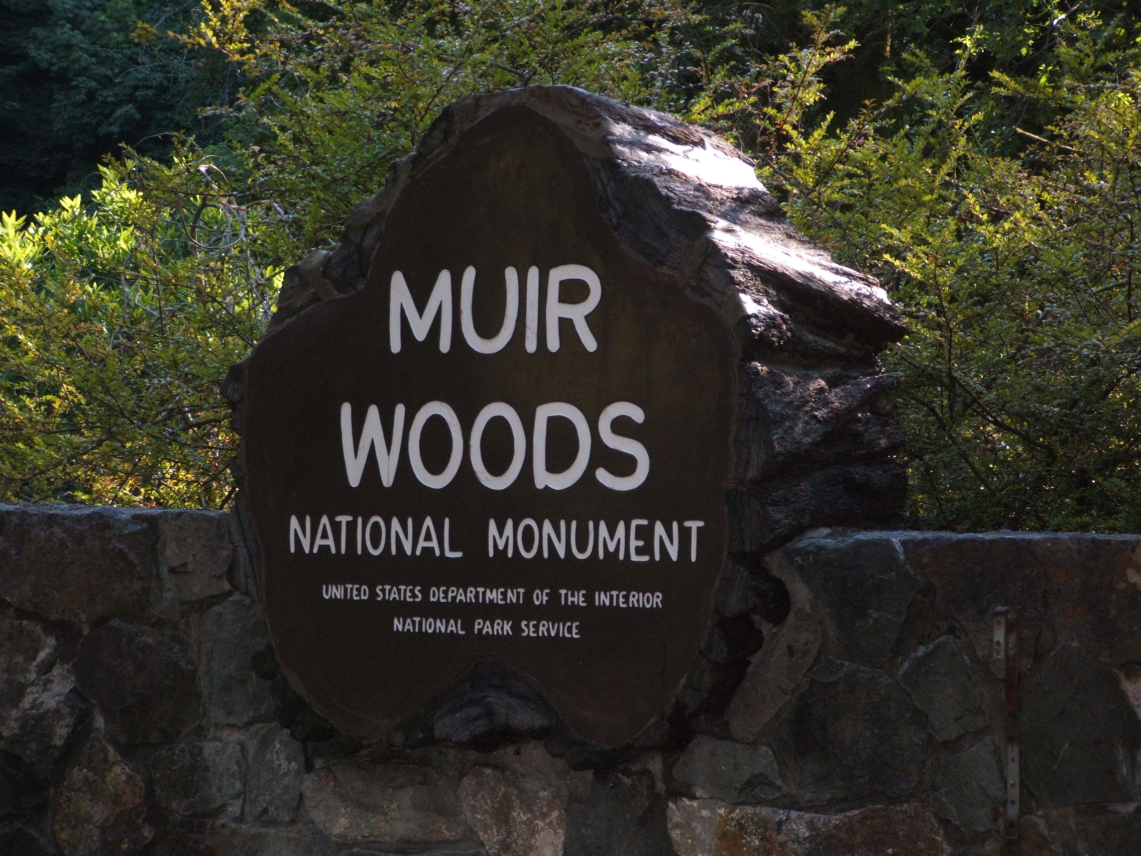
- Muir Woods National Monument
-
Muir Woods National Monument IUCN Category III (Natural Monument)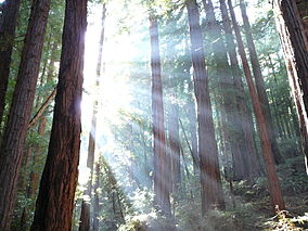
Sunlight shining through redwood trees at the Muir Woods National Monument

Location Marin County, California, USA Nearest city Mill Valley, CA Coordinates 37°53′56″N 122°35′2″W / 37.89889°N 122.58389°WCoordinates: 37°53′56″N 122°35′2″W / 37.89889°N 122.58389°W Area 559 acres (226 ha) Established January 9, 1908 Visitors 775,941 (in 2005) Governing body National Park Service Muir Woods National Monument is a unit of the National Park Service on the Pacific coast of southwestern Marin County, California, 12 miles (19 km) north of San Francisco and part of the Golden Gate National Recreation Area. It protects 559 acres (226 ha),[1] of which 240 acres (97 ha) are old growth Coast Redwood (Sequoia sempervirens) forests,[2] one of a few such stands remaining in the San Francisco Bay Area.
Contents
Geography
Ecosystem
 Old-growth coastal redwoods
The Muir Woods National Monument is an old-growth coastal redwood forest. Due to its proximity to the Pacific Ocean, the forest is regularly shrouded in a coastal marine layer fog, contributing to a wet environment that encourages vigorous plant growth. The fog is also vital for the growth of the redwoods as they use moisture from the fog during the dry summer.
Climate
The monument is cool and moist year round with average daytime temperatures between 40 and 70 degrees Fahrenheit (4 to 21 °C). Rainfall is heavy during the winter and summers are almost completely dry with the exception of fog drip caused by the fog passing through the trees. Annual precipitation in the park ranges from 39.4 inches (1,000 mm) in the lower valley to 47.2 inches (1,200 mm) higher up in the mountain slopes.
Soils
The redwoods grow on brown humus-rich loam which may be gravelly, stony or somewhat sandy. This soil has been assigned to the Centissima series, which is always found on sloping ground. It is well drained, moderately deep, and slightly to moderately acidic. It has developed from fine-grained sandstone and shale. More open areas of the park have shallow gravelly loam of the Barnabe series, or deep hard loam of the Cronkhite series.
History
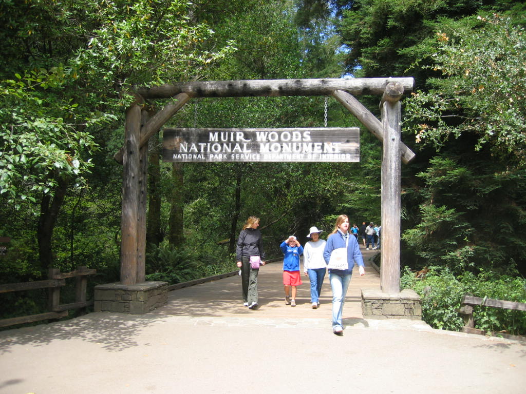
 Main entrance to Muir Woods National Monument, 2006
One hundred fifty million years ago ancestors of redwood and sequoia trees grew throughout the United States. Today, the Sequoia sempervirens can be found only in a narrow, cool coastal belt from Monterey, California, in the south to Oregon in the north.
Before the logging industry came to California, there were an estimated 2 million acres (8,000 km2) of old growth forest containing redwoods growing in a narrow strip along the coast.
By the early 20th century, most of these forests had been cut down. Just north of the San Francisco Bay, one valley named Redwood Canyon remained uncut, mainly due to its relative inaccessibility.
This was noticed by U.S. Congressman William Kent. He and his wife, Elizabeth Thacher Kent, purchased 611 acres (247 ha) of land from the Tamalpais Land and Water Company for $45,000 with the goal of protecting the redwoods and the mountain above them.
In 1907, a water company in nearby Sausalito planned to dam Redwood Creek, thereby flooding the valley. When Kent objected to the plan, the water company took him to court to attempt to force the project to move ahead. Kent sidestepped the water company's plot by donating 295 acres (119 ha) of the redwood forest to the federal government, thus bypassing the local courts.
On January 9, 1908, President Theodore Roosevelt declared the land a National Monument, the first to be created from land donated by a private individual. The original suggested name of the monument was the Kent Monument but Kent insisted the monument be named after naturalist John Muir, whose environmental campaigns helped to establish the National Park system. President Roosevelt agreed, writing back:
- MY DEAR MR. KENT: By George! you are right.
and, responding to some photographs of Muir Woods that Mr. Kent had sent him,
- Those are awfully good photos.[3]
In December 1928, the Kent Memorial was erected at the Kent Tree in Fern Canyon. This tree—a Douglas fir, not a redwood—was said to be Kent's favorite. Due to its height of 280 feet (85 m) and location on a slope, the tree leaned towards the valley for more than 100 years. According to Muir Woods Storms in El Niño years of 1981 and 1982 caused the tree to tilt even more and took out the top 40 feet (12 m) of the tree. During the winter of 2002–03, many storms brought high winds to Muir Woods causing the tree to lean so much that a fissure developed in January 2003. This fissure grew larger as the tree slowly leaned more and more, forcing the closure of some trails. On March 18, 2003, at around 8:28 pm, the tree fell, damaging several other trees nearby. The closed trails have since been reconfigured and reopened.
In 1937, the Golden Gate Bridge was completed and park attendance tripled, reaching over 180,000. Muir Woods is one of the major tourist attractions of the San Francisco Bay Area, with 776,000 visitors in 2005.
In the spring of 1945, delegates from 50 countries met in San Francisco to draft and sign the United Nations Charter. President Franklin Delano Roosevelt died on April 12, 1945, shortly before he was to have opened the United Nations Conference. On May 19, the delegates held a commemorative ceremony in tribute to his memory in Muir Woods' Cathedral Grove, where a dedication plaque was placed in his honor.
The monument was listed on the National Register of Historic Places on January 9, 2008.[4]
Biology
Flora
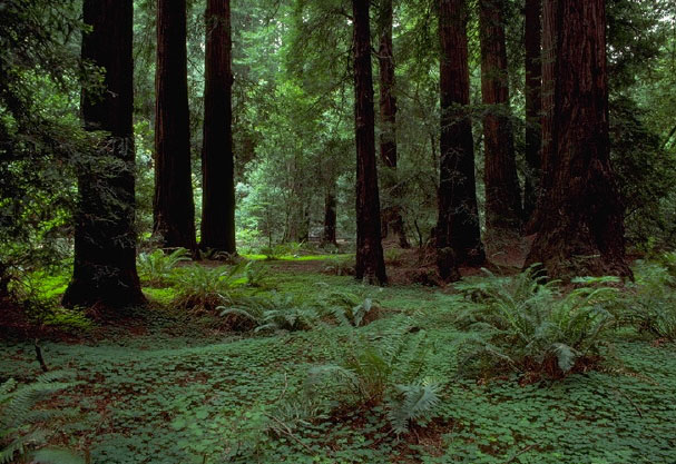
 Undergrowth of a redwood canopy demonstrating the deep shadow under the trees. Note the clearing in the background showing other trees growing in the light.
The star attraction of the Muir Woods is the Coast Redwood (Sequoia sempervirens). These relatives of the Giant Sequoia are known for their height. While redwoods can grow to nearly 380 feet (115 m), the tallest tree in the Muir Woods is 258 feet (79 m). The trees come from a seed no bigger than that of a tomato's.[5] The average age of the redwoods in the Monument are between 500 and 800 years old with the oldest being at least 1,200 years old.
While overshadowed (and shaded) by their tall cousins, other tree species grow in the understory of the woods. Three of the most common are the California Bay Laurel, the Bigleaf Maple and the Tanoak. Each of these species has developed a unique adaptation to the low level of dappled sunlight that reached them through the redwoods growing overhead. The California Bay Laurel has a strong root system that allows the tree to lean towards openings in the canopy. The bigleaf maple, true to its name, has developed the largest leaf of any maple species allowing it to capture more of the dim light. The tanoak has a unique internal leaf structure that enables it to make effective use of the light that filters through the canopy.
Fauna
Fish
Redwood Creek provides a critical spawning and rearing habitat for coho or silver salmon (Oncorhynchus kisutch), coastal cutthroat (Oncorhynchus clarki clarki) and steelhead trout (Oncorhynchus mykiss), each of them threatened species. The creek is near the southernmost limit of coho habitat and the fish have never been stocked, so they have a distinctive DNA. The Redwood Creek salmon are Central Coast Coho Salmon which have been listed as federally threatened species since October 2006 and as federally endangered species in June 2005. Coho migrate from the ocean back to freshwater for a single chance at reproduction, generally after two years in the ocean. The spawning migrations begin after heavy late fall or winter rains breach the sandbar at Muir Beach allowing the fish to move upstream (usually in December and January).[6] No salmon were seen in the 2007–2008 winter run, nor the 2008–2009 winter run. Evidence points to exhaustion of smolt oversummering in the creek due to a loss of large woody debris and deep pools where young salmon can rest. Starting in 2009, the National Park Service began restoring Muir Beach to create a functional, self-sustaining ecosystem and improve visitor access.[7] The intervention was almost too late, since the coho only has a three year life span. Fortunately, as of January, 2010, and for the first time in three years, an estimated 45 Coho swam up Redwood Creek to spawn, creating 23 redds or clusters of eggs.[8] In 2011, 11 live adult coho and 1 coho carcass was observed, along with three redds, a modest increase over the 2007-2008 spawning season.[9] Statewide the coho population is 1% of its levels in the 1940s and the fish have vanished from 90% of the streams they formerly visited.[10][11]
Birds
Muir Woods is home to over 50 species of birds.[12] This relatively low number is due to the lack of insects. The tannin in the trees repels the insects and the volume of flowers and fruits produced by plants below the canopy is limited by the shade of the redwoods.
It is occasionally possible to see Northern Spotted Owls or Pileated Woodpeckers in the forest. While decreasing in numbers elsewhere, the spotted owls appear to be thriving in the Monument and other evergreen forests in the area. A National Park Service monitoring project of the owls is ongoing within the monument. The project has found that adult owls are finding mates, raising young to adulthood and the young are having new broods of their own.
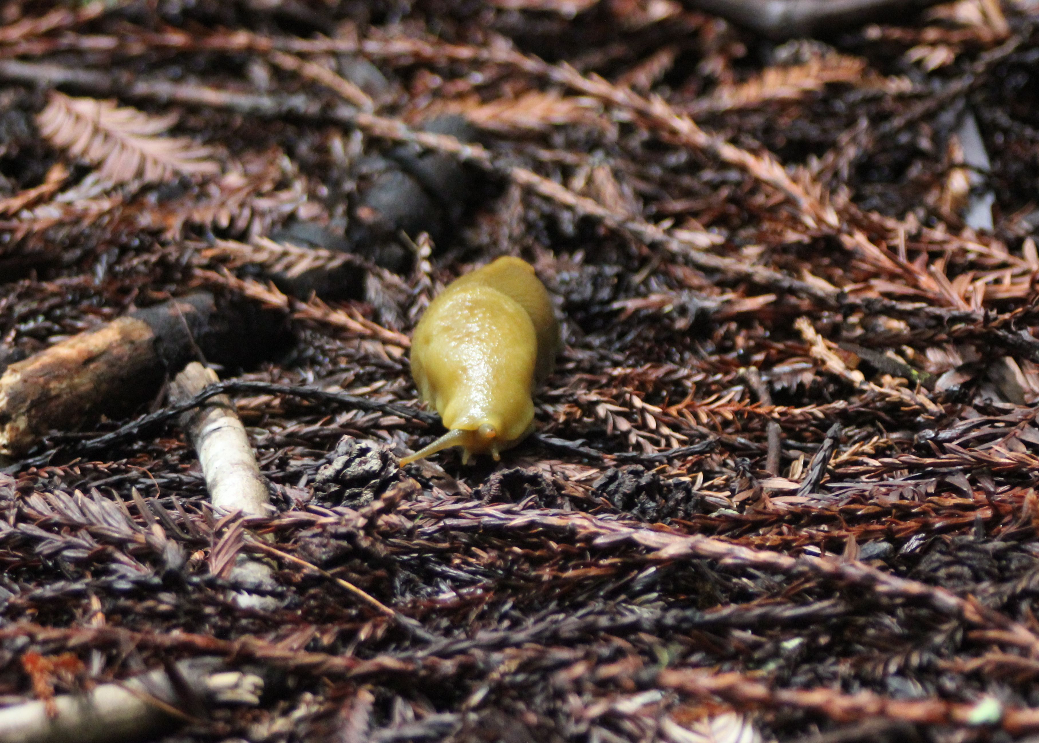
 Banana Slugs are common in Muir Woods
Mammals
The monument is home to a variety of mammals ranging in size from the American Shrew Mole to much larger deer. The majority of the mammals are not seen as they are nocturnal or are burrowing animals living under the ground or the dense litter on the forest floor. Most commonly seen are Sonoma chipmunks, and Western gray squirrels.[13]
Bears historically roamed the area but were largely exterminated by habitat destruction. In 2003 a male black bear was spotted wandering in various areas of Marin County, including Muir Woods.
There are 11 species of bats that call the monument home, often using hollows burned into the redwoods by past fires as a maternity colony.
In November, 2010 sea otters (Enhydra lutris) have been spotted swimming in the new stream channel constructed in the lagoon area of Redwood Creek.[8]
Recreation
Muir Woods, part of the Golden Gate National Recreation Area, is a park which caters to pedestrians, as parking of vehicles is only allowed at the very entrance. Hiking trails vary in the level of difficulty and distance. Picnicking, camping and pets are not permitted.
 The entrance to Muir Woods National Monument
Facilities
Lodging/camping
There are no camping or lodging facilities in the Muir Woods. The monument is a day-use area only. There are camping facilities in the adjacent Mount Tamalpais State Park.
Comfort facilities
- Restrooms
- Aramark Cafe and Gift Shop – deli food items and souvenirs. Also has a permanent display of historic photographs.
- 1.5 miles (2.4 km) of paved, wheelchair accessible trails
Interpretive facilities
- Visitors Center with permanent and changing exhibits. Also contains a gift shop.
Activities
Hiking and biking
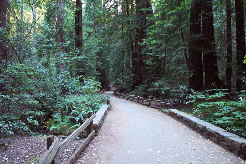
File:Northern California Muir Woods – National Monument.jpg One of the paved trails in Muir Woods
The monument has a number of paved walking trails (Trail Map) where visitors can get a close look at the magnificent giants. Other unpaved walking trails lead up the hills to connect with trails outside of the Monument boundaries.
Bicycles are only allowed on fire roads.
Athletic Events
The annual Dipsea Race, a footrace which goes between Mill Valley and Stinson Beach, passes through Muir Woods on the second Sunday in June. The Double Dipsea, later in June and the Quad Dipsea, in November, follow the same course.
Ranger-led activities
 Sunlight on leaves and spider webs in Muir Woods
Ranger-led walks on a number of different topics, including discussions on the watershed, wildflowers, and tidepools are held on weekends. Moonlight walks are held on nights with a full moon. Reservations are required for the moonlight walks.
Daily presentations are possible if staffing permits.
Special events are held for the summer and winter solstices.
Weddings
Weddings are allowed in the Monument with a proper permit.
External links
- NPS page for Muir Woods
- NPS page for planning your visit to Muir Woods, in seven languages
- Web Soil Survey (select Marin County)
- Parks Conservancy page with details of 100 year anniversary celebration on January 9, 2007
References
- ^ "Muir Woods Tour Manual – 2008". National Park Service. http://www.nps.gov/muwo/planyourvisit/upload/Microsoft%20Word%20-%20Tour%20Manual%202008%20Final.pdf. Retrieved 2009-01-19.
- ^ Bolsinger, Charles L.; Waddell, Karen L. (1993). Area of old-growth forests in California, Oregon, and Washington. United States Forest Service, Pacific Northwest Research Station. Resource Bulletin PNW-RB-197. http://www.fs.fed.us/pnw/pubs/pnw_rb197.pdf.
- ^ Muir Woods (1930), includes letters to and from President Roosevelt
- ^ "National Register Information System". National Register of Historic Places. National Park Service. 2009-03-13. http://nrhp.focus.nps.gov/natreg/docs/All_Data.html.
- ^ http://www.nps.gov/muwo/
- ^ Carlisle, S., M. Reichmuth, E. Brown, and S. C. Del Real (2008). Long-term coho salmon and steelhead trout monitoring in coastal Marin County 2007: annual monitoring progress report. Natural Resource Technical Report NPS/SFAN/NRTR—2009/269 (Report). Fort Collins, Colorado: National Park Service. https://science1.nature.nps.gov/naturebib/biodiversity/2009-12-2.2/StreamfishAnnual07NRTRFinal.pdf. Retrieved Jan. 5, 2010.
- ^ Michelle O’Herron (August 2009). "Coho Salmon Monitoring in Redwood Creek, Inventory and Monitoring Program Research Project Summary". National Park Service. http://science.nature.nps.gov/im/units/sfan/reports/Executive%20Briefings/Coho_ResourceBriefing.pdf. Retrieved Jan. 5, 2009.
- ^ a b Peter Fimrite (2010-11-12). "Marin creek being restored to bring back coho". San Francisco Chronicle. http://www.sfgate.com/cgi-bin/article.cgi?f=/c/a/2010/11/12/MN1O1GAMHQ.DTL. Retrieved 2010-11-14.
- ^ [www.sfnps.org/download_product/2428/0 2010-2011 Coho and Steelhead Spawner Survey Summary] (Report). National Park Service. www.sfnps.org/download_product/2428/0. Retrieved 2011-05-15.
- ^ Mark Prado (Jan. 2, 2010). "Marin's coho salmon on the brink of extinction". Marin Independent Journal. http://www.marinij.com/marinnews/ci_14113750. Retrieved Jan. 12, 2010.
- ^ Donna Whitmarsh (Jan. 2010). "California Coho Salmon In Dire Straits, New Report Predicts Collapse". Bay Nature. http://baynature.org/articles/web-only-articles/california-coho-salmon-in-dire-straits. Retrieved Jan. 12, 2010.
- ^ The Birds of Muir Woods National Monument. Muir Woods National Monument – Birds, U.S. National Park Service. Last updated on September 2001. Accessed 2010-08-09.
- ^ Muir Woods National Monument (Official Map & Guide). National Parks Service. Retrieved 2010-06-29.
Historic districts China Camp | Fort Baker | Fort Barry | Fort Cronkhite | Hamilton Army Air Field Discontiguous Historic District | Larkspur Downtown Historic District | Point Bonita Light Station | Point Reyes Light Station
Belvedere Valentine Rey HouseInverness Brock Schreiber Boathouse and Beach | Pierce Ranch | Point Reyes Lifeboat Rescue Station, 1927Larkspur Alexander-Acacia Bridge | Dolliver House | Green Brae Brick YardTiburon Muir Beach Archeological Site | Steamship Tennessee remainsMarshall Station KPH Operating Station | Station KPH, Marconi Wireless Telegraph Company of AmericaMill Valley Muir Woods National Monument | Outdoor Art Club | The Dipsea TrailNovato Fashion Shop and Stephen Porcella House | Rancho Olompali | Robert Dollar Estate | Robert Dollar HouseOlema San Rafael Boyd House | Bradford House | Dixie Schoolhouse | Erskine B. McNear House | Marin County Civic Center | San Rafael Improvement ClubSausalito Griswold House | Sausalito Woman's Club | William G. Barrett HouseTiburon Tomales Tomales Presbyterian Church and Cemetery
U.S. National Register of Historic Places Topics Lists by states Alabama • Alaska • Arizona • Arkansas • California • Colorado • Connecticut • Delaware • Florida • Georgia • Hawaii • Idaho • Illinois • Indiana • Iowa • Kansas • Kentucky • Louisiana • Maine • Maryland • Massachusetts • Michigan • Minnesota • Mississippi • Missouri • Montana • Nebraska • Nevada • New Hampshire • New Jersey • New Mexico • New York • North Carolina • North Dakota • Ohio • Oklahoma • Oregon • Pennsylvania • Rhode Island • South Carolina • South Dakota • Tennessee • Texas • Utah • Vermont • Virginia • Washington • West Virginia • Wisconsin • WyomingLists by territories Lists by associated states Other Protected areas of California National Park System National Parks National Preserves National Monuments Cabrillo · Devils Postpile · Lava Beds · Muir Woods · Pinnacles · World War II Valor in the Pacific National MonumentNational Seashores National Historical Parks National Historic Sites National Memorials Port Chicago Naval MagazineNational Recreation Areas National Forests National Forests Angeles · Cleveland · Eldorado · Inyo · Klamath · Lassen · Los Padres · Mendocino · Modoc · Plumas · San Bernardino · Sequoia · Shasta-Trinity · Sierra · Six Rivers · Stanislaus · TahoeNational Wilderness
Preservation SystemAgua Tibia · Ansel Adams · Bucks Lake · Caribou · Carson-Iceberg · Castle Crags · Cucamonga · Desolation · Dick Smith · Dinkey Lakes · Emigrant · Golden Trout · Hoover · Inyo Mountains · Ishi · Jennie Lakes · John Muir · Kaiser · Marble Mountain · Mokelumne · Mount Shasta Wilderness · North Fork · San Gabriel · Sanhedrin · San Jacinto · San Rafael · Sespe · Siskiyou · Snow Mountain · South Fork Eel River · South Sierra · South Warner · Thousand Lakes · Trinity Alps · Ventana · Yolla Bolly-Middle Eel · YukiOther State Forests Boggs Mountain Demonstration · Ellen Pickett · Jackson Demonstration · Las Posadas · LaTour Demonstration · Mount Zion · Mountain Home Demonstration · Soquel Demonstration
National Wildlife Refuges Antioch Dunes · Bitter Creek · Blue Ridge · Butte Sink · Castle Rock · Clear Lake · Coachella Valley · Colusa · Delevan · Don Edwards San Francisco Bay · Ellicott Slough · Farallon · Guadalupe-Nipomo Dunes · Hopper Mountain · Humboldt Bay · Kern · Lower Klamath · Marin Islands · Merced · Modoc · Pixley · Sacramento · Sacramento River · Salinas River · San Diego Bay · San Diego · San Joaquin River · San Luis · San Pablo Bay · Seal Beach · Sonny Bono Salton Sea · Stone Lakes · Sutter · Tijuana Slough · Tule LakeState Wildlife Areas Wildlife Areas Antelope Valley · Ash Creek · Bass Hill · Battle Creek · Big Lagoon · Big Sandy · Biscar · Butte Valley · Buttermilk Country · Cache Creek · Camp Cady · Cantara/Ney Springs · Cedar Roughs · Cinder Flats · Collins Eddy · Colusa Bypass · Coon Hollow · Cottonwood Creek · Crescent City Marsh · Crocker Meadows · Daugherty Hill · Decker Island · Doyle · Dutch Flat · Eastlker River · Eel River · Elk Creek Wetlands · Elk River · Fay Slough · Feather River · Fitzhugh Creek · Fremont Weir · Grass Lake · Gray Lodge · Green Creek · Grizzly Island · Hallelujah Junction · Heenan Lake · Hill Slough · Hollenbeck Canyon · Honey Lake · Hope Valley · Horseshoe Ranch · Imperial · Indian Valley · Kelso Peak and Old Dad Mountains · Kinsman Flat · Knoxville · Laguna · Lake Berryessa · Lake Earl · Lake Sonoma · Little Panoche Reservoir · Los Banos · Lower Sherman Island · Mad River Slough · Marble Mountains · Mendota · Merrill's Landing · Miner Slough · Monache Meadows · Morro Bay · Moss Landing · Mouth of Cottonwood Creek · Napa-Sonoma Marshes · North Grasslands · O'Neill Forebay · Oroville · Petaluma Marsh · Pickel Meadow · Pine Creek · Point Edith · Putah Creek · Rector Reservoir · Red Lake · Rhode Island · Sacramento River · San Felipe Valley · San Jacinto · San Luis Obispo · San Luis Reservoir · San Pablo Bay · Santa Rosa · Shasta Valley · Silver Creek · Slinkard/Little Antelope · Smithneck Creek · South Fork · Spenceville · Surprise Valley · Sutter Bypass · Tehama · Truckee River · Upper Butte Basin · Volta · Warner Valley · Waukell Creek · West Hilmar · Westlker River · White Slough · Willow Creek · Yolo BypassEcological Reserves Albany Mudflats · Alkali Sink · Allensworth · Atascadero Creek Marsh · Bair Island · Baldwin Lake · Batiquitos Lagoon · Blue Sky · Boden Canyon · Boggs Lake · Bolsa Chica · Bonny Doon · Buena Vista Lagoon · Butler Slough · Butte Creek Canyon · Butte Creek House · Buttonwillow · By Day Creek · Calhoun Cut · Canebrake · Carlsbad Highlands · Carmel Bay · Carrizo Canyon · Carrizo Plains · China Point · Clover Creek · Coachella Valley · Coal Canyon · Corte Madera Marsh · Crestridge · Dairy Mart Ponds · Dales Lake · Del Mar Landing · Eden Landing · Elkhorn Slough · Estelle Mountain · Fall River Mills · Fish Slough · Fremont Valley · Goleta Slough · Indian Joe Spring · Kaweah · Kerman · King Clone · Laguna Laurel · Loch Lomond Vernal Pool · Lokern · Magnesia Spring · Marin Islands · Mattole River · McGinty Mountain · Morro Dunes · Morro Rock · Napa River · North Table Mountain · Oasis Spring · Panoche Hills · Peytonia Slough · Pine Hill · Piute Creek · Pleasant Valley · Point Lobos · Rancho Jamul · Redwood Shores · River Springs Lakes · Saline Valley · San Dieguito Lagoon · San Elijo Lagoon · San Felipe Creek · San Joaquin River · Santa Rosa Plateau · Springville · Stone Corral · Sycamore Canyon · Sycuan Peak · Thomes Creek · Tomales Bay · Upper Newport Bay · Watsonville Slough · West Mojave Desert · Woodbridge · YaudanchiMarine Protected Areas Abalone Cove · Agua Hedionda Lagoon · Albany Mudflats · Anacapa · Anacapa · Año Nuevo · Asilomar · Atascadero Beach · Bair Island · Batiquitos Lagoon · Big Creek · Big Creek · Big Sycamore Canyon · Bodega · Bolsa Chica · Buena Vista Lagoon · Cambria · Cardiff and San Elijo · Carmel Bay · Carmel Pinnacles · Carrington Point · Catalina Marine Science Center · Corte Madera Marsh · Crystal Cove · Dana Point · Del Mar Landing · Doheny · Doheny · Duxbury Reef · Edward F. Ricketts · Elkhorn Slough · Elkhorn Slough · Encinitas · Estero de Limantour · Fagan Marsh · Farallon Islands · Farnsworth Bank · Fort Ross · Gerstle Cove · Goleta Slough · Greyhound Rock · Gull Island · Harris Point · Heisler Park · Hopkins · Irvine Coast · James V. Fitzgerald · Judith Rock · Julia Pfeiffer Burns · La Jolla · Laguna Beach · Lovers Cove (Catalina Island) · Lovers Point · MacKerricher · Manchester and Arena Rock · Marin Islands · Mia J. Tegner · Moro Cojo Slough · Morro Bay · Morro Bay · Morro Beach · Natural Bridges · Niguel · Pacific Grove Marine Gardens · Painted Cave · Peytonia Slough · Piedras Blancas · Piedras Blancas · Pismo · Pismo-Oceano Beach · Point Buchon · Point Buchon · Point Cabrillo · Point Fermin · Point Lobos · Point Reyes Headlands · Point Sur · Point Sur · Portuguese Ledge · Punta Gorda · Redwood Shores · Refugio · Richardson Rock · Robert E. Badham · Robert W. Crown · Russian Gulch · Russian River · Salt Point · San Diego-Scripps · San Dieguito Lagoon · San Elijo Lagoon · Santa Barbara Island · Scorpion · Skunk Point · Sonoma Coast · Soquel Canyon · South Laguna Beach · South Point · Tomales Bay · Upper Newport Bay · Van Damme · Vandenberg · White Rock (Cambria)National Landscape Conservation System National Monuments National Conservation Areas California Desert · King RangeWilderness Areas Argus Range · Big Maria Mountains · Bigelow Cholla Garden · Bighorn Mountain · Black Mountain · Bright Star · Bristol Mountains · Cadiz Dunes · Carrizo Gorge · Chemehuevi Mountains · Chimney Peak · Chuckwalla Mountains · Chumash · Cleghorn Lakes · Clipper Mountain · Coso Range · Coyote Mountains · Darwin Falls · Dead Mountains · Dick Smith · El Paso Mountains · Fish Creek Mountains · Funeral Mountains · Golden Valley · Grass Valley · Headwaters Forest Reserve · Hollow Hills · Ibex · Indian Pass · Inyo Mountains · Jacumba · Kelso Dunes · Kiavah · Kingston Range · Little Chuckwalla Mountains · Little Picacho · Machesna Mountain · Matilija · Malpais Mesa · Manly Peak · Mecca Hills · Mesquite · Newberry Mountains · Nopah Range · North Algodones Dunes · North Mesquite Mountains · Old Woman Mountains · Orocopia Mountains · Otay Mountain · Owens Peak · Pahrump Valley · Palen/McCoy · Palo Verde Mountains · Picacho Peak · Piper Mountain · Piute Mountains · Red Buttes · Resting Spring Range · Rice Valley · Riverside Mountains · Rodman Mountains · Sacatar Trail · Saddle Peak Hills · San Gorgonio · Santa Lucia · Santa Rosa · Sawtooth Mountains · Sespe · Sheephole Valley · South Nopah Range · Stateline · Stepladder Mountains · Surprise Canyon · Sylvania Mountains · Trilobite · Turtle Mountains · Whipple Mountains ·National Marine Sanctuaries National Estuarine Research Reserves Elkhorn Slough · San Francisco Bay · Tijuana River Estuary
University of California Natural Reserve System Año Nuevo Island · Bodega Marine · Box Springs · Boyd Deep Canyon Desert Research Center · Burns Piñon Ridge · Carpinteria Salt Marsh · Chickering American River · Coal Oil Point · Dawson Los Monos Canyon · Eagle Lake Field Station · Elliott Chaparral · Emerson Oaks · Fort Ord · Hastings · James San Jacinto Mountains · Jenny Pygmy Forest · Jepson Prairie · Kendall-Frost Mission Bay Marsh · Kenneth S. Norris Rancho Marino · Landels-Hill Big Creek · McLaughlin · Motte Rimrock · Quail Ridge · Sagehen Creek Field Station · San Joaquin Freshwater Marsh · Santa Cruz Island · Scripps Coastal · Sedgwick · Stebbins Cold Canyon · Steele Burnand Anza-Borrego · Stunt Ranch Santa Monica Mountains · Sweeney Granite Mountains Desert Research Center · Valentine Eastern Sierra · Younger LagoonHeritage registers: World Heritage Sites · World Network of Biosphere Reserves · National Register of Historic Places · National Historic Landmarks · National Natural Landmarks · California Historical Landmarks · California Points of Historical Interest · California Register of Historical Resources
Categories:- IUCN Category III
- Forests of California
- Parks in Marin County, California
- Golden Gate National Recreation Area
- National Park Service National Monuments in California
- Old growth forests
- History of Marin County, California
- National Register of Historic Places in the San Francisco Bay Area
- Protected areas established in 1908


Wikimedia Foundation. 2010.