Dara-I-Pech District — (also known as Manogay District or Pech District[1]) is located western central part of Kunar Province, Afghanistan, 30 km West from Asadabad. The population is 48,400 (2006). The district is governed from Mano Gai.[2] The governor is… … Wikipedia
Dara-I-Suf District, Samangan — DarahSof was a district in Samangan Province, northern Afghanistan. Until 2005, the district was dissolved and it is now split into 2 new districts surrounding the now, former bigger Darah Sof district: Darah Sof Balla Darah Sof Payan … Wikipedia
Dara — Cette page d’homonymie répertorie les différents sujets et articles partageant un même nom. Dara peut désigner : Sommaire 1 Personnes 1.1 Prénoms … Wikipédia en Français
District d'Afghanistan — Districts de Afghanistan. Les provinces d Afghanistan sont divisés en Wolaswalei (Pashto: ولسوالۍ) ou districts. Le nombre de districts en Afghanistan a fluctué au fil des ans, avec de nouveaux districts créés par scission ou fusion des parties… … Wikipédia en Français
Chahar Dara District — (also known as Char Dara, Chahar Darreh or Char Darreh) is one of the seven districts in Kunduz Province in northern Afghanistan. It is situated in the south west part of Kunduz Province and has borders with Qalay I Zal District to the north west … Wikipedia
Nijrab District — Country Afghanistan Region Kapisa Province … Wikipedia
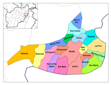
Asadabad District — is one of 15 districts in Kunar Province, Afghanistan. It includes the city of Asadabad the district center, close the Kunar River. It is situated in the central part of the province. It has 12 big and small villages, which are surrounded by… … Wikipedia
Nawa-I-Barakzayi District — Not to be confused with Nawa District. Coordinates: 31°22′59″N 64°18′00″E / 31.383°N 64.3°E / 31.383; 64.3 … Wikipedia
Nurgal District — is situated in the western part of Kunar Province, Afghanistan, 90 km West from Asadabad, and is near Jalalabad city. It borders Nangarhar Province to the west and south, Chapa Dara district to the north and Chawkay and Khas Kunar districts… … Wikipedia
Chapa Dara District — is situated in the western part of Konar Province, Afghanistan and borders Nuristan Province. The population is 27,500 (2006). The district is mountainous and farming and animal husbandry are not possible in the whole district. Some people work… … Wikipedia
 Nangarhar districts.
