- Newton, Kansas
-
Newton, Kansas — City — Newton City Hall, 2006
Motto: Life as it Should Be Location of Newton, Kansas Map of Harvey County, Kansas
Coordinates: 38°2′39″N 97°20′51″W / 38.04417°N 97.3475°WCoordinates: 38°2′39″N 97°20′51″W / 38.04417°N 97.3475°W Country United States State Kansas County Harvey Founded 1871 Incorporated 1872, 1880 Government - Type City Commission - Mayor Willis Heck - Vice-Mayor Ken Hall Area - Total 11.73 sq mi (30.38 km2) - Land 11.73 sq mi (30.38 km2) - Water 0.0 sq mi (0.0 km2) Elevation 1,447 ft (441 m) Population (2010)[1] - Total 19,132 - Density 1,631/sq mi (629.7/km2) Time zone Central (CST) (UTC-6) - Summer (DST) CDT (UTC-5) ZIP code 67114 Area code(s) 316 FIPS code 20-50475[2] GNIS feature ID 0484319[3] Website www.NewtonKansas.com Newton is a city in and the county seat of Harvey County, Kansas, United States.[4] As of the 2010 census, the city population was 19,132.[1] Newton is located 25 mi (40 km) north of Wichita and is included in the Wichita metropolitan statistical area (MSA). The city of North Newton is located immediately north of the city, existing as a separate political entity.
Contents
History
 Downtown Newton, 2006
In 1871 the Atchison, Topeka and Santa Fe Railway built a main line east-west through Newton.[5]
From its beginnings Newton came to be known as "bloody and lawless—the wickedest city in the west." This reputation was much due to the 1871 Gunfight at Hide Park, in which a total of eight men were ultimately killed. In 1872 the western terminal for the Atchison, Topeka and Santa Fe Railway and the railhead for the Chisholm Trail were established here. Shortly after incorporation of the City in 1872, the Newton city council passed an ordinance prohibiting the running at large of buffalo and other wild animals.
The history of Newton is intertwined with the Railway. Newton served as the Middle Division dispatching headquarters for the "Santa Fe" until the mid 1980s, when all dispatching for the Chicago to Los Angeles system was centralized in the Chicago area. In 1995 the Santa Fe merged with the Burlington Northern Railroad, and is now known as the BNSF Railway. The BNSF continues to be a large industrial taxpayer although its impact as an employer has decreased in the past decade. Most locals still refer to this railroad as the "Santa Fe".
During World War II, the Newton airport was taken over by the US Navy as a secondary Naval Air Station, and the main runway was extended to over 7,000 feet (2,100 m).
Geography
Newton is in the central portion of the continental United States. U.S. Highway 81, also known as the Meridian Highway, stretches from Winnipeg, Manitoba, Canada to Mexico City, Mexico through Central and South America. It passes through Newton, Kansas and is known as "Main Street." U.S. Highway 50 runs past the White House in Washington, DC through Newton, Kansas and continues on to Sacramento, California.
The city has a total area of 11.73 square miles (30.4 km2), all land with the exception of Sand Creek and several small tributaries.[6]
Demographics
 Blue Sky Sculpture, Centennial Park
Historical populations Census Pop. %± 1900 6,208 — 1910 7,862 26.6% 1920 9,781 24.4% 1930 11,034 12.8% 1940 11,048 0.1% 1950 11,590 4.9% 1960 14,877 28.4% 1970 15,439 3.8% 1980 16,332 5.8% 1990 16,700 2.3% 2000 17,190 2.9% 2010 19,132 11.3% U.S. Decennial Census As of the census[2] of 2000, there were 17,190 people, 6,851 households, and 4,610 families residing in the city. The population density was 1,794.0 people per square mile (692.8/km²). There were 7,277 housing units at an average density of 759.5 per square mile (293.3/km²). The racial makeup of the city was 86.73% White, 2.30% African American, 0.53% Native American, 0.66% Asian, 0.03% Pacific Islander, 6.84% from other races, and 2.92% from two or more races. Hispanic or Latino of any race were 12.73% of the population.
There were 6,851 households out of which 31.9% had children under the age of 18 living with them, 54.2% were married couples living together, 9.6% had a female householder with no husband present, and 32.7% were non-families. 28.9% of all households were made up of individuals and 12.1% had someone living alone who was 65 years of age or older. The average household size was 2.43 and the average family size was 2.99.
In the city the population had 26.3% under the age of 18, 8.1% from 18 to 24, 28.2% from 25 to 44, 20.8% from 45 to 64, and 16.5% who were 65 years of age or older. The median age was 37 years. For every 100 females there were 93.3 males. For every 100 females age 18 and over, there were 90.1 males.
The median income for a household in the city was $38,236, and the median income for a family was $45,703. Males had a median income of $32,308 versus $21,906 for females. The per capita income for the city was $18,529. About 5.1% of families and 7.9% of the population were below the poverty line, including 9.7% of those under age 18 and 5.6% of those age 65 or over.
Newton is located in Harvey County which is an agricultural and small manufacturing county with 34,361 people. Harvey County Kansas is part of a four county "Metro Area" with about a half million people. The major city in this metro area is Wichita, Kansas, 20 miles (20 minutes) to the South via I-135.
Area attractions
- Kansas Sports Museum[7]
- Harvey County Historical Society Library and Museum[8]
- Kauffman Museum[9]
- Warkentin House, a Victorian house museum.
- Mennonite Settler statue
- Blue Sky Sculpture
- Carriage Factory Art Gallery[10]
- Sand Creek Station Golf Course,[11] 18-hole public course, ranked among 2006's best new public courses in America by Golf Digest.
Education
 Newton High School, 2006
Primary and secondary education
Newton is part of Unified School District 373.[12][13] Newton public schools consist of Newton High, Santa Fe Middle, Chisholm Middle, Sunset Elementary, Northridge Elementary, Southbreeze Elementary, Slate Creek Elementary, and Walton agricultural charter school (in Walton, Kansas). Newton also has two private K-8 schools, Newton Bible Christian School and St. Mary's Catholic School,[14] and a private high school; Newton Christian High School (rural north of Newton).
College
Bethel College is located nearby in the City of North Newton.
Media
Newton is served by local media as well as that of Wichita and national media. The following lists include both local media and media from the Wichita MSA.
Print media
The Newton Kansan (GateHouse Media) serves Newton and the surrounding area as the daily local newspaper. It is not published on Sundays. The Wichita Eagle is the major newspaper for the region.
Television
- ATSC (digital television)
- Channel 3-1: KSNW - NBC National Broadcasting Company
- Channel 8-1: KPTS - PBS Public Broadcasting Company
- Channel 8-2: KPTS - PBS Public Broadcasting Company
- Channel 8-3: KPTS - PBS Public Broadcasting Company
- Channel 10-1 KAKE - ABC American Broadcasting Company
- Channel 12-1: KWCH - CBS Columbia Broadcasting Company
- Channel 12-2: KWCH - CBS 24 hour weather
- Channel 24-1: KSAS - Fox FOX Broadcasting Company
- Channel 33-1: KWCV - CW The CW Television Network
- Channel 36-1: KMTW - MyTV MyNetwork Television
Cox Communications supplies Newton with cable Television
Radio
- AM
- KJRG-AM 950 kHz
- FM
- KFTI-FM 92.3 MHz
- KBCU-FM 88.1 MHz - Bethel College (Kansas) - College events and Jazz music
Infrastructure
Transportation
 Newton Amtrak Depot, 2006See also: Newton (Amtrak station)
Major highways (I-135, US-50, US-81, K-15), an airport, and the BNSF Railway make Newton a central location for transportation and shipping. Amtrak's Southwest Chief stops in Newton twice each day and provides passenger rail service towards Los Angeles and Chicago.[15] The Amtrak station is located at 414 N Main St.[16]
Newton City/County Airport, FAA:EWK,[17] is located 2 miles east of Newton. Its 7,002-foot (2,134 m) runway is one of only 11 runways in Kansas 7,000-foot (2,100 m) or longer. It has ILS and GPS approach.[18][19]
Utilities
- Internet
- Cable is provided by Cox Communications.
- Wireless is provided by Pixius Communications.
- Satellite is provided by HughesNet, StarBand, WildBlue.
- TV
- Cable is provided by Cox Communications.
- Satellite is provided by DirecTV, Dish Network.
- Terrestrial is provided by regional digital TV stations.
- Telephone
- Electricity
- City is provided by Westar Energy.
- Gas is provided by Kansas Gas Service.
- Water
- City is provided by City of Newton.
- Rural is provided by Harvey County RWD #1.
- Sewer is billed by City of Newton.
- Trash is billed by City of Newton.
Notable people
- Tom Adair, screenwriter, musician, and composer
- Errett Bishop, Mathematician
- Tony Clark, Major league baseball first baseman
- Reed Crandall, Comic book artist
- Phil Epp, Artist [20]
- Harold E. Foster, Head coach of the Wisconsin Badgers men's basketball team, member of the Naismith Memorial Basketball Hall of Fame[21]
- Elizabeth Hoisington, American Army General
- John Mills Houston, Politician and Mayor of Newton[22]
- John M. Janzen, Professor of Anthropology, Author
- J.E. Keeny, 1908 to 1926 president of Louisiana Tech University, operated a mercantile store in Newton in 1886[23]
- Robert Kreh, Independent Filmmaker, Multimedia Artist [24]
- Sean Mann, Bioethicist, Linguist, Academic
- Dustin Richardson, Major League Baseball pitcher
- Jacob A. Schowalter, Philanthropist. Founder of Schowalter Foundation and Kansas State Representative.
- Conrad Snider, Clay Artist[25]
- Jesse Unruh, California Politician
- Mike Wellman, National Football League center
See also
 Carnegie Library, 1912
- National Register of Historic Places listings in Harvey County, Kansas
- Newton High School
- Abilene Trail
- Chisholm Trail
References
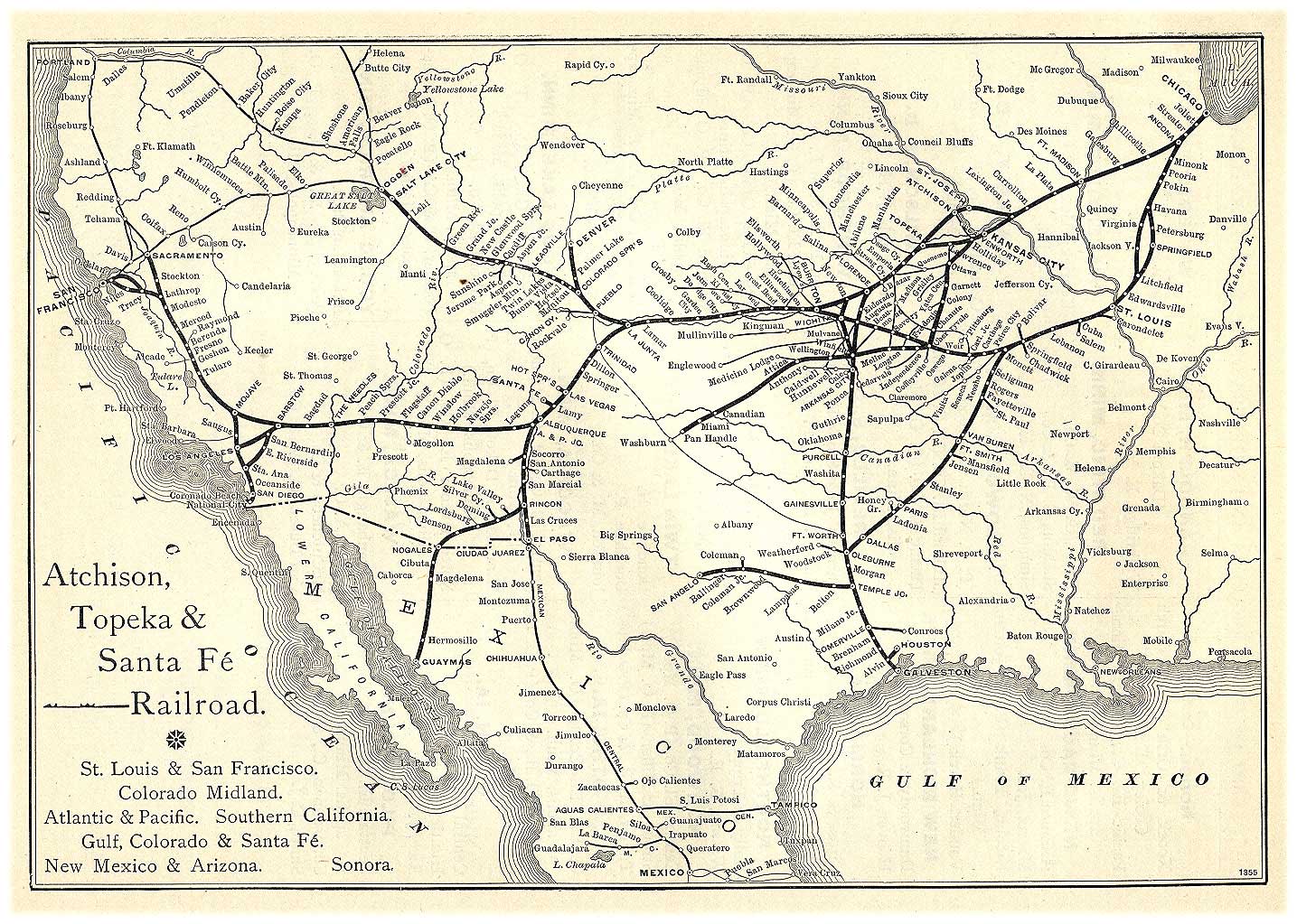
 An Atchison, Topeka & Santa Fe Railway route map from 1891 issue of Grain Dealers and Shippers Gazetteer.
- ^ a b "2010 City Population and Housing Occupancy Status". U.S. Census Bureau. http://factfinder2.census.gov/faces/tableservices/jsf/pages/productview.xhtml?pid=DEC_10_PL_GCTPL2.ST13&prodType=table. Retrieved March 6, 2011.
- ^ a b "American FactFinder". United States Census Bureau. http://factfinder.census.gov. Retrieved 2008-01-31.
- ^ "US Board on Geographic Names". United States Geological Survey. 2007-10-25. http://geonames.usgs.gov. Retrieved 2008-01-31.
- ^ "Find a County". National Association of Counties. http://www.naco.org/Counties/Pages/FindACounty.aspx. Retrieved 2011-06-07.
- ^ Santa Fe Rail History
- ^ City of Newton, Kansas
- ^ Kansas Sports Museum - Kansas Travel
- ^ Harvey County Historical Society Library and Museum
- ^ Kauffman Museum
- ^ Carriage Factory Art Gallery
- ^ Sand Creek Station Golf Course
- ^ USD 373
- ^ Kansas School District Boundary Map
- ^ St. Mary's Catholic School
- ^ Amtrak - Southwest Chief route
- ^ Amtrak - Newton Station
- ^ Newton City/County Airport map
- ^ Newton City/County Airport web site
- ^ Newton City/County Airport information
- ^ Phil Epp
- ^ Basketball Hall Of Fame - Harold E. Foster
- ^ http://www.kshs.org/kansapedia/kansans-in-u-s-congress/14490
- ^ "Keeny, John Ephraim". Louisiana Historical Association, A Dictionary of Louisiana Biography (lahistory.org). http://www.lahistory.org/site28.php. Retrieved December 27, 2010.
- ^ Robert Kreh - Bio
- ^ Conrad Snider
Further reading
- History of the State of Kansas; William G. Cutler; A.T. Andreas Publisher; 1883. (Online HTML eBook)
- Kansas : A Cyclopedia of State History, Embracing Events, Institutions, Industries, Counties, Cities, Towns, Prominent Persons, Etc; 3 Volumes; Frank W. Blackmar; Standard Publishing Co; 944 / 955 / 824 pages; 1912. (Volume1 - Download 54MB PDF eBook),(Volume2 - Download 53MB PDF eBook), (Volume3 - Download 33MB PDF eBook)
External links
- City
- City of Newton
- Newton - Directory of Public Officials
- Newton Area Chamber of Commerce & Visitors Bureau
- Schools
- USD 373, school district for Newton, North Newton, Walton
- Historical
- Maps
- Newton City Map, KDOT
- Harvey County Map, KDOT
- Topo Map of Newton / North Newton / Walton area, USGS
Municipalities and communities of Harvey County, Kansas County seat: NewtonCities 
Townships Unincorporated
communitiesMcLain | Patterson | Putnam | Zimmerdale
Ghost town Footnotes ‡This populated place also has portions in an adjacent county or counties
Categories:- Cities in Kansas
- County seats in Kansas
- Populated places in Harvey County, Kansas
- Wichita metropolitan area


Wikimedia Foundation. 2010.