- Docklands, Victoria
-
Docklands
Melbourne, Victoria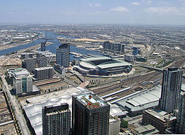
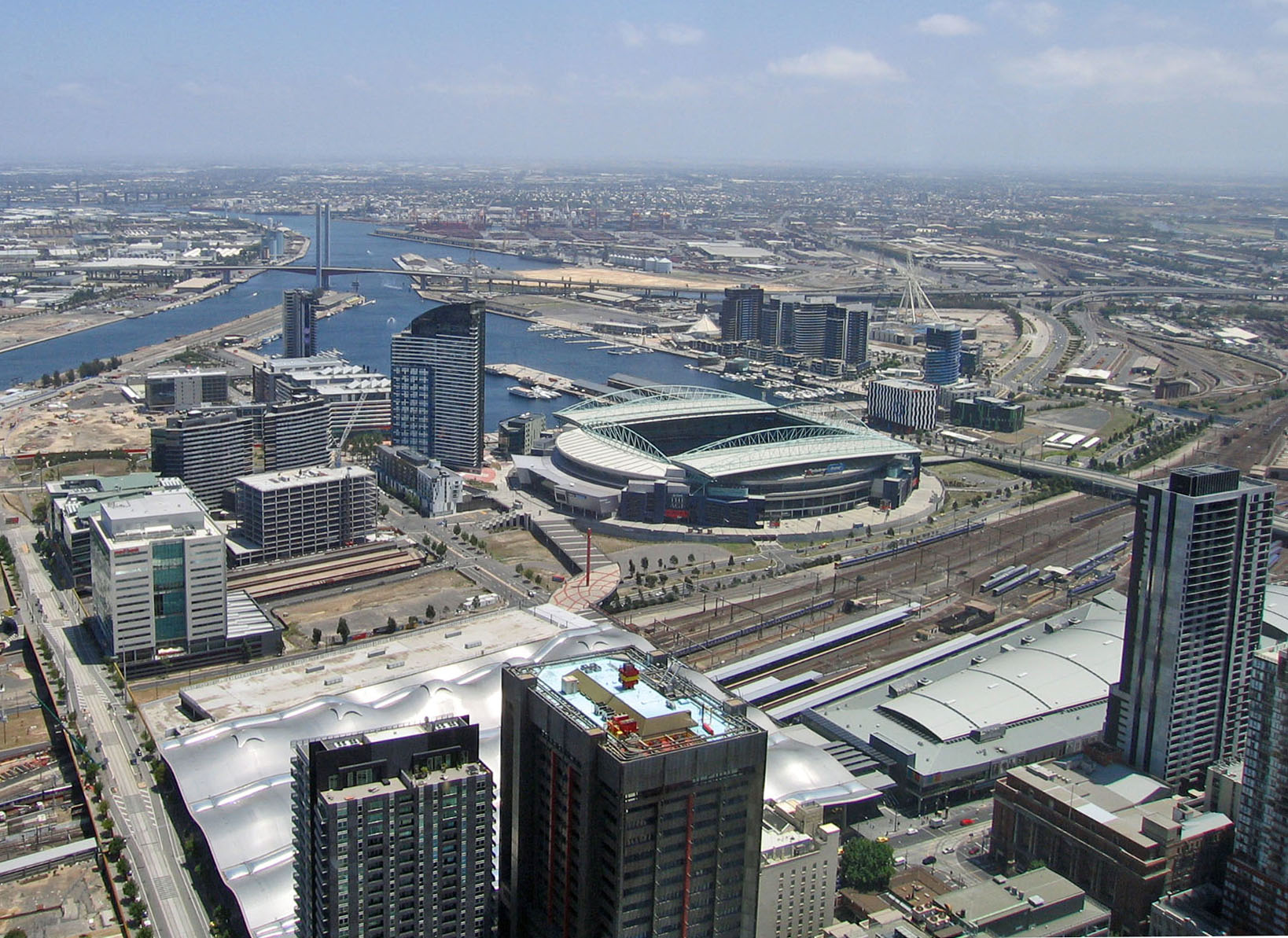
View toward Docklands from high above the Melbourne CBD in 2008. From left to right - Batmans Hill & Southern Cross Station; Victoria Harbour; Stadium Precinct; New Quay; Waterfront City; Digital Harbour
 Docklands
Population: 3939 (2006)[1] Established: 2000 Postcode: 3008 Area: 3 km² (1.2 sq mi) Location: 2 km (1 mi) from Melbourne CBD LGA: City of Melbourne State District: Melbourne Federal Division: Melbourne Suburbs around Docklands: Footscray West Melbourne North Melbourne Yarraville Docklands Melbourne Port Melbourne Port Melbourne Southbank Docklands (also known as Melbourne Docklands to differentiate it from London Docklands) is an inner city suburb in Melbourne, Victoria, Australia occupying an area extending up to 2 km west of and adjacent to Melbourne's Central Business District (CBD). Its Local Government Area is the City of Melbourne. Demographically, Docklands has a population, according to the 2006 Census, of 3,939.
It is bounded by Spencer Street, Wurundjeri Way and Charles Grimes Bridge to the east, CityLink to the west and Lorimer Street across the Yarra to the south and is a primarily waterfront area centred around the banks of the Yarra River.
Contemporary Docklands is the product of an ongoing urban renewal project to extend the area of the CBD (excluding Southbank and St Kilda Road) by over a third when completed around 2015. It is now home to several of Melbourne's modern landmarks including Etihad Stadium, Southern Cross Station and The Southern Star.
From the 1880s, the former swamp west of Melbourne became heavily used as a dock with an extensive network of wharfs, heavy rail infrastructure and light industry. However following the containerisation of shipping traffic it fell into disuse and by the 1990s was virtually abandoned, becoming notable for an underground rave dance scene,[2] a dance culture which survives through popular organised events held at Docklands Stadium.
Docklands Stadium (first known as Colonial Stadium) was built in 1996 as a centrepiece to kick-start developer interest in Docklands as a viable renewal area. Urban renewal began in earnest 2000 with several independent privately developed areas overseen by VicUrban, an agency of the State government of Victoria. The brief for the master plan was for wide open water promenades and road boulevards with contributions of landscaping and public art commissions to be made by each developer and construction was to adhere to strict milestones. VicUrban promotes its vision of Docklands as being a major tourist attraction and projected over 20 million visitors a year and a future (2015) residential population of over 20,000[citation needed].
A handful of significant buildings were retained, generally due to their association with the area's industrial and maritime history. Most of these heritage buildings are intended for adaptive reuse and integrated with new facilities.
Docklands has become a sought-after business address,[3] attracting the national headquarters of National Australia Bank, ANZ, Medibank Private, Bureau of Meteorology, Myer, National Foods as well as the regional headquarters for AXA Asia Pacific, Ericsson and Bendigo Bank.[4] The business park model of medium-rise office buildings combined with transport and proximity to city centre is seen by many in the real estate industry to be one of the reasons behind the success of the Docklands office market.
Docklands is also the home to a number of water sports including Dragon Boat racing.
While still incomplete, Docklands developer-centric planning has been widely criticised and many Melbourne politicians and media commentators lament its lack of green open space,[5] pedestrian activity, transport links and culture.[6][7][8]
The name "Docklands" is contrived from the word "dock" (in reference to the area's maritime history) and "land", with the name directly inspired by the name of the contemporary development in England, London Docklands.
Contents
History
 Illustration of the rapidly changes to area of Batman's Hill
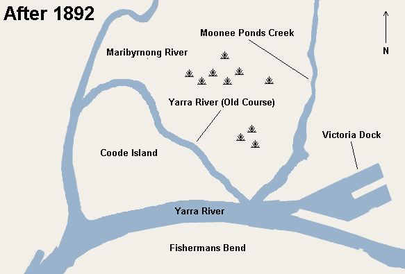
Before the foundation of Melbourne, Docklands was a wetlands area consisting of a large salt lake (on the current site of Victoria Harbour) and a giant swamp (known as West Melbourne Swamp) at the mouth of Moonee Ponds Creek. It was one of the open hunting grounds of the Wurundjeri people who created middens around the edges of the lake.
At Melbourne's foundation, John Batman set up his home on Batman's Hill at Docklands, marking the westernmost point of the settlement. However the rest of the area remained largely unused for decades.
The advent of rail infrastructure in the late 1860s saw the city's industry gradually expand into the area.
The earliest extensive plans to develop the area in the 1870s when a plan was prepared to extend the Hoddle Grid westward, following the curve of the Yarra River and effectively doubling its size. The plan proposed several gridlike blocks with an ornamental public garden and lake in the shape of the United Kingdom occupying the site of the salt lake. However expansion of the grid westward was abandoned in favour of a northward extension.
1880s: Construction of a new Victoria Dock
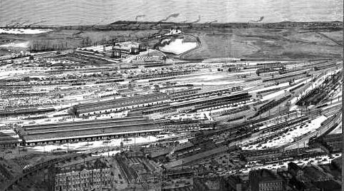
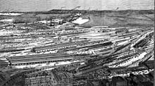 Lithograph of the area in 1889 looking west from the Hoddle Grid, showing the progress at Victoria Docks and the domination of the area by the railyards and sheds of the Spencer Street Station complex
A major engineering project began in the 1880s to reroute the course of the Yarra River and this resulted in the widening of the river for shipping and the creation of a new Victoria Dock (the name was previously used by one of the docks at Queensbridge as early as the 1850s). The dock was lined with wharves and light industry grew around the nearby western rail yards of Spencer Street railway station (now Southern Cross railway station) which were used for freighting the goods inland.
-

Illustration of the Yarra before the creation of Victoria Docks
-

Illustration of the reconfiguration and widening of the Yarra with the creation of Victoria Docks (right)
Interwar Shipping era
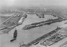 Busy Victoria Docks in the 1920s
During the wars, Victoria Dock was used as the main port for naval vessels and most of the Victorian troops returned from both wars to the docks.
By the 1920s, with shipping moved from the Yarra turning basin at Queensbridge, Victoria Dock and surrounding port had become Melbourne's busiest[citation needed].
Disuse
With the introduction of containerisation of Victoria's shipping industry in the 1950s and 60s, the docks along the Yarra River east of the modern Bolte Bridge, and within Victoria Harbour immediately to the west of the central business district, became inadequate for the new container ships.
The creation of Appleton Dock and Swanston Dock in an area west of the Moonee Ponds Creek now known as West Melbourne, closer to the mouth of the Yarra, became the focus of container shipping effectively rendering a vast amount of vacant inner-city land to the immediate west of Melbourne's CBD redundant.
Early renewal proposals
Docklands was seen as a large urban blight by the Cain state government. Property consultants JLW Advisory carried out the first market demand assessment of the site.[9]
The size of the Melbourne Docklands area meant that political influences were inescapable. The Docklands project was on top of the government's agenda,[10] however, due to the poor condition of the wharf infrastructure, much investment was required to initiate the project which the government at the time could not afford. Nevertheless, the Docklands project stayed on the drawing board, but with little progress.[citation needed] In 1990, the Docklands Task Force was established to devise an infrastructure strategy and conduct the public consultation process.[10] The Committee For Melbourne, a not for profit organisation that brought together the private sector of Melbourne for a public good, was pursuing another planning strategy. It involved a bid for the Olympic Games and another proposal to turn the Docklands into a technology city known as the Multifunction Polis (MFP). Both bids fell through in late 1990.[10] Nevertheless, the Committee For Melbourne's approach became the preferred model in the proceeding strategies for the Docklands development, leading to the formation of the Docklands Authority in July 1991.[10]
Kennett Era - wheels set in motion
With a government running in budget deficits, not much progress was made on the Docklands project. In Late 1992, Jeff Kennett was elected Premier. Kennett instituted many changes and turned the government's financial position around. He then embarked on a multitude of projects, which included Docklands. It was politically imperative to get the project rolling, the Docklands Authority opted for the concept of having leaving all design and funding of infrastructure to the developers. The development industry supported this, and claimed that the project would be more efficient. Docklands was divided into sections or precincts which were to be tendered to private companies to be developed.
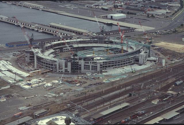
 Docklands Stadium under construction (Christmas 1998)
May 1996 saw the relaunch of the tender process. Few restrictions were applied to the bids from developers, and as the vision was to make Docklands 'Melbourne's Millennium Mark', the key criterion for a successful bid was to get projects going by 2000.[10] It did not take long for the realisation that the lack of government coordination in infrastructure planning would create problems. Developers would not invest into public infrastructure where benefits would flow on to an adjacent property. This was corrected by allowing developers to negotiate for infrastructure funding with the government. The Docklands Village precinct was planned for a residential and commercial mixed development, but, in late 1996, that plan was scrapped when it was announced a private football stadium would be built on the site.[10] The site was chosen for its easy access to the then Spencer Street Station (now Southern Cross Station), and it was intended to be an anchor for the entire project and provide for a clear signal to the long awaited start of the Docklands project. However, this would create a huge barrier between the city and Docklands.
In 1989, several architectural firms were invited to discuss how the area could best serve the Melbourne public.
The commission to design the overall plan was granted to Ashton Raggatt McDougall by the Docklands Authority.
During 1998 and 1999, with the exception of Yarra Waters (later Yarra's Edge) bid by Mirvac, bid for every other precinct fell through, the reasons are often unclear due to secrecy provisions.[10] and a change of government occurred.
Docklands rave history
Docklands became notable during the 1990s for its underground rave dance scene.[2]
The site was host to a number of dance parties hosted by Future Entertainment and Hardware Corporation during the 1990s.[citation needed] DJs and performers such as Paul van Dyk, Carl Cox, Jeff Mills, Frankie Knuckles, David Morales, Marshall Jefferson and BT headlined these events. The biggest event hosted, in terms of attendance, was the "Welcome 2000" New Year's Eve dance party hosted on 31 December 1999.[citation needed]
Bracks Era: New Tender Process
In 2000, a newly elected government of premier Steve Bracks released a new tender for Docklands Development via Vic Urban (a rebranded Docklands Authority).
Through the tendering process for the sites, the business park was split once more and awarded to two consortia, becoming Entertainment City (renamed Paramount Studios) - a movie theme park with film studios, to be developed by a Viacom led consortium, and Yarra Nova (which later evolved into NewQuay) to the MAB Corporation consortium. The Paramount Studios proposal fell through, and the site was put to tender once more, as Studio City, and later awarded as two parts, becoming what is now the Central City Studios and Waterfront City.
Yarra Waters/Yarra Quays was awarded to Mirvac later becoming Yarra's Edge.
The technology park was renamed Commonwealth Technology Port (or Comtech Port) before finally becoming Digital Harbour.
A number of other sites also encountered false starts, with Victoria Harbour originally being awarded to Walker Corporation, before being put out to tender again and finally being awarded to Lend Lease Group in April 2001. The Batman's Hill precinct was originally awarded to Bruno Grollo's Grocon, which had plans for what would have been the world's tallest building rising 560 m, dubbed Grollo Tower and featuring a mix of office, apartment, hotel and retail. This deal also fell through with the site being subdivided into 15 parcels as well as Rail Goods Shed No.2.
- Site 1/753 Bourke Street - awarded to Pan Urban.
- Site 2a/737 Bourke Street - Equiset.
- Site 2b/750 Collins Street - Grocon.
- Goods Shed North/733 Bourke Street - Equiset/Pan Urban JV.
- Site 3a/700 Collins Street - Leighton Holdings.
- Site 3b/717 Bourke Street - Global Campus Management/Babcock & Brown.
- Site 5a - Kangan Batman TAFE.
- Site 5b - Under negotiation, Sama Dubai.
- Site 6 - Under negotiation, Sama Dubai.
- Site 7/643 Collins Street - Grocon.
City of Melbourne - gradual handover
On 1 July 2007 Docklands became part of the City of Melbourne local government authority however VicUrban retains planning authority until 2010.
Heritage
Significant heritage buildings include 67 Spencer Street, former railway offices (adaptively reused as the "Grand Hotel" apartments), the railway goods sheds (adaptively reused as an indoor market),[11] The Mission to Seafarers building,[12] Victoria Dock and Central Pier,[13] Queens Warehouse (adaptively reused as a vintage car museum),[14] Docklands park gantry crane and a small number of warehouses and container sheds.
Districts
The area is broken up into a number of precincts, which are each being designed and built by a different development company.
Batman's Hill
The Batman's Hill precinct is bordered by the Yarra River to the south, Spencer Street to the east, Docklands Stadium to the north and Victoria Harbour to the west. The precinct is named after the historical landmark Batman's Hill,[citation needed] which was once situated within the area.
It is a mixed-use precinct including commercial and retail space, entertainment, hotels, residential sections, restaurants, cultural sites and educational institutions as well as the historic Rail Goods Shed No. 2, which was split in half to allow for the extension of Collins Street into Docklands, providing businesses with an address that is considered to be prestigious. The area is 100,000 square metres.[citation needed]
More than half the precinct is already built, committed or under construction, and includes the Watergate/Site One apartment and small office complex, 700 Collins Street (home to the Bureau of Meteorology and Medibank Private), 750 Collins Street (the headquarters of AXA Asia Pacific), Kangan Institute's Automotive Centre for Excellence (ACE) and the Fox Classic Car Museum. 717 Bourke Street (consisting of a 294 room Travelodge Hotel and 737 Bourke Street (home to National Foods).[citation needed]
On 2 August 2007, it was reported that a $1.5 billion scheme had been earmarked for Collins Street by Middle Eastern investment company Sama Dubai, to be designed by architect Zaha Hadid and Melbourne firm Ashton Raggatt McDougall. The plan would consist of four buildings, including Docklands' tallest tower as well as civic spaces spanning two sites to be built on decking over Wurundjeri Way. The proposed tower will be between 50 to 60 storeys tall but did not proceed and VicUrban put the site back out to tender in early 2011. [15]
The offices of Fairfax Media are at 643 Collins Street. The new building, known as Media House, comprises 16,000 m2 of office space accommodating 1,400 staff, on decking over railway lines opposite Southern Cross Station. The $110 million eight-storey facility was designed by architects Bates Smart to achieve a 5-star Green Star rating, and will feature a news ticker, outdoor screen and grassy plaza. It iwas developed by Grocon in 2009.[16]
Collins Square
Formerly known as Village Docklands, Collins Square is a 3ha precinct, within the larger Batman's Hill precinct being developed by Walker Corporation.
Collins Square is the outcome of a split of precincts in the tender process in 2000 which resulted in Goods Shed South, 735 Collins Street and Sites 4a-4f originally awarded to a Kuok Group and Walker Corporation JV.
A masterplan prepared by Marchese + Partners in conjunction with Bligh Voller Nield architects was approved in early 2002, it included a 60 storey Shangri-La Hotels and Resorts tower with a Collins Street address and a mix of commercial and residential towers, as well as the refurbishment of the southern half of Goods Shed No. 2 into a night market and food hall.
In mid 2007, a new, more commercially orientated masterplan was prepared by Bates Smart. In it a new 38 storey office tower replaced the Shangri La hotel on Collins Street and the number of streets is reduced from four to three, replaced by pedestrian thoroughfares. Overall there will now be five office buildings, ranging in height from 155m (to roof) to 36 m and the refurbishment of the Goods Shed with a 'lantern' structure addressing Collins Street. The entire precinct is aiming for a 5 Star Green Star rating.
On 17 December 2007, Walker Corporation launched the next phase of construction, beginning with demolition works and site preparation.[17][18]
Stadium Precinct
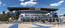 Stadium precinct plaza, Harbour Esplanade and Docklands Stadium
 Victoria Point apartment tower completed in 2005
The Stadium precinct, which sits on the eastern edge of Docklands, consists of Etihad Stadium, Seven Network's Melbourne digital broadcasting centre, Victoria Point, Bendigo Bank offices, and Quest serviced apartments. It is linked to Southern Cross Station and the Melbourne CBD by the Bourke Street pedestrian bridge, built over railway lines.
During the 2000 Docklands development tender process, the stadium precinct was divided into four corners, the North West Stadium Precinct (NWSP), North East Stadium Precinct (NESP), North East Stadium Precinct (NESP) and South West Stadium Precinct (SWSP). The NWSP was awarded to Channel 7/Pacific Holdings. The NESP was awarded to Pan Urban. The SWSP was awarded to Devine Limited/RIA Property Group and the SESP - Bourke Junction Consortium (ISPT, CBUS Property and EPC Partners).
Etihad Stadium (originally Colonial Stadium) was opened in March 2000. The ability for the structure to have both open and closed roof configurations has seen it host many sports events, including Australian Rules Football, soccer, cricket and rugby as well as concerts. The stadium complex is currently managed by Stadium Operations Ltd[citation needed], which is owned by the Seven Network, with ownership transferring to the Australian Football League in 2025[citation needed].
Developer Pan Urban has announced plans for a $300 million twin-tower apartment development known as Lacrosse Docklands for the NESP with the towers set to rise 21 and 18 storeys respectively, above the stadium concourse, with restaurants and bars opening out on to the concourse, forming a retail plaza.[19]
Plans for the site to be known as Bourke Junction include office towers of 29 and 21 storeys on the north-eastern and south-western corners of the SESP site, as well as three lower-rise buildings housing a 250 room hotel, a pub, medical centre, retail facilities, a business club and a two-level gymnasium.[20]
Digital Harbour at Comtechport Precinct
 The completed Port 1010 building at the Digital Harbour precinct
Digital Harbour is a waterfront has an area of 44,000 square metres, with development intended to expand to include 220,000 square metres of commercial, residential, SOHO units and retail space. At present only three buildings have been completed; 1010 LaTrobe Street/Port 1010 (home to VicTrack, Australian Customs Service), and the Innovation Building (home of the Telstra Learning Academy and Innovation Centre). A third building, Life.lab currently resides at 198 Harbour Esplanade, while a fourth, 1000 LaTrobe Street, is expected to commence shortly.
Port 1010 received the Commercial Architecture Award at the 2007 Victorian Architecture Awards held on Friday 13 July.[21]
The Digital Harbour Business Association was launched in 2011, this is a group of businesses established in the Digital Harbour precinct in the Docklands. The precinct is a destination for IT, Media and other related businesses. The aim of the Association is to promote the businesses within Digital Harbour to the wider Docklands Community and Melbourne CBD.
Victoria Harbour
 View toward Victoria Harbour National Australia Bank HQ (centre) Erricson building and Dock 5 tower (right) from the stadium terrace
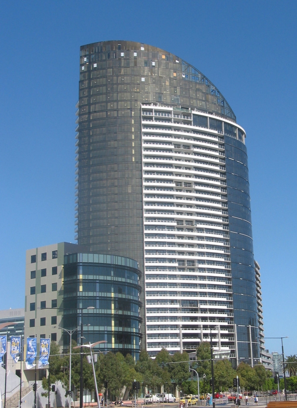
 The ANZ headquarters, Victoria Harbour. Viewed from Docklands Park
The Victoria Harbour Precinct is the centrepiece of Docklands. The precinct includes a proposed extension of Collins Street and Bourke Street to meet at the water's edge. It has an area of 280,000 square metres with 3.7 kilometres of waterfront. The 12-year construction plans for Victoria Harbour include residential apartments, commercial office space, retail space, community facilities and the development of public spaces such as Grand Plaza, Harbour Esplanade, Docklands Park and Central Pier, Melbourne.
One of the first completed office buildings in the precinct was the colourful National Australia Bank headquarters, located at 800 Bourke Street, which accommodates approximately 3,600 staff. The building has large open floor plates, an atria, a campus-style workplace and a four-star energy rating.
Almost 1,000 Ericsson employees also call Victoria Harbour home, with the company's new Melbourne offices at 818 Bourke Street. Ericsson House sits on the water's edge next door to National Australia Bank HQ and Dock 5 apartments
The first residential tower to be built at Victoria Harbour was Dock 5. Rising 30 storeys, it was designed by award-winning Melbourne firm John Wardle Architects and HASSELL, derives its name from its location which was known as Dock 5.
The Gauge, at 825 Bourke Street will house the new offices of developer Lend Lease and Fujitsu. The eight-storey building was designed to achieve a six-star energy rating, becoming the second building in Docklands to do so.
A Safeway supermarket opened in Merchant Street (opposite The Gauge) in 2008 , along with a number of other retail tenancies at street level including an optometry practice called Kaleyedoscope, Australia Post, a childcare centre, and offices above.
In 2009 the Australia and New Zealand Banking Group (ANZ)'s new world headquarters at 833 Collins Street have been completed. The office complex includes shops, car parking facilities and a YMCA. It enables 6,500 ANZ staff to work in one integrated area. The new ANZ headquarters designed by HASSELL, developed by Lend Lease, was expected to become the largest office complex in Australia. Construction commenced in late 2006 with completion expected in 2009. It has been designed to achieve a six-star energy rating.
In 2007, Myer announced that it had chosen Victoria Harbour as the location for its new Corporate Store Support Offices. The new offices are being built at 800 Collins Street opposite ANZ.[22]
NewQuay
 View of New Quay from the Central Pier. From the left the Nolan, Arkley, Palladio and Boyd.
NewQuay, opened in 2002 was one of the first residential and commercial developments in Docklands. It currently has five residential towers and a podium building developed by MAB Corporation. The flagship building Palladio - which is shaped like the prow of a ship - is named after Italian architect Andrea Palladio. The podium building, Sant'Elia is named after another Italian architect Antonio Sant'Elia. The rest are named after Australian artists: Nolan (Sidney Nolan), Arkley (Howard Arkley), Boyd (Arthur Boyd), and Conder (Charles Conder).
Aquavista, completed in May 2007, is a strata office development and the first commercial building to be completed in NewQuay as part of the HQ NewQuay development. Another, the seven-storey 370 Docklands Drive is currently under construction with a further two buildings - Lots 5 & 9 - currently under design development.[23]
On 17 October 2007, MAB Corporation launched 'The Avenues at NewQuay' development, consisting of three-storey townhouse residences, with park and waterfront frontages, to be built as part of NewQuay's western precinct. The development is being designed by Plus Architecture.[24][25]
The ground level podiums contain a commercial precinct with a variety of restaurants and cafes including Italian, Indian, Middle Eastern, Cantonese, Moroccan, Cambodian and Modern Australian cuisines.
Yarra's Edge
 Webb Bridge from the Yarra's Edge marina
Yarra's Edge is a residential precinct being developed by Mirvac, and the only Docklands precinct south of the Yarra River. When complete, it will consist of 11 apartment towers, costing A$1.3 billion, and cover 0.15 km2.
Yarra's Edge was one of the first developments in the Docklands, with construction of Tower 1 commencing in 2000. It is divided into 3 smaller precincts:
The Marina Precinct: Comprising the marina and boardwalk with six residential towers ranging in height from 25 to 47 storeys
The Park Precinct: Comprising Point Park and two residential towers
The River Precinct: Comprising a mix of lower level less, intense terrace-style developments and three high-rise towers towards the Bolte Bridge.
To date only five apartment towers have been completed as well as the RekDek (located in the podium of Tower 1 and featuring a gymnasium and 25 metre lap pool), a public promenade, Point Park (with an outlook towards the Melbourne CBD and mix of restaurants, cafes and retail including a day spa and convenience store. Yarra's Edge also has a 175-berth marina, giving boat owners previously unavailable proximity to Crown Casino and the city.
Webb Bridge is an award winning bridge designed by Denton Corker Marshall in collaboration with artist Robert Owen, forming a cycling and pedestrian link to the main part of Docklands through Docklands Park. It is the conversion of the former Webb Bridge rail link. The bridge is near the Charles Grimes Bridge over the Yarra.
Waterfront City
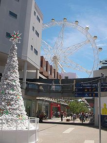 Waterfront City and Southern Star wheel (in 2008 before disassembly)
Waterfront City is a shopping and entertainment area that includes The Southern Star Ferris wheel, Icehouse ice sports and entertainment centre, and numerous shops and cafes which are centred around this area.
The precinct on features an integration of retail, waterfront entertainment, tourism, dining, commercial and urban community. It has an area of 193,000 square metres.
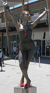
Stage One was completed in December 2005 in time for the Melbourne Stopover of the Volvo Ocean Race in January – February 2006 and the Commonwealth Games in March 2006. The precinct currently features a large circus tent which hosts the International Circus Spectacular as well as mosaic of local entertainers and a number of bronze statues of including Kylie Minogue, John Farnham, Graham Kennedy, Nellie Melba and Dame Edna.
Stage Two includes a public entertainment area incorporating The Southern Star, a 120-metre (390 ft) tall Ferris wheel in the shape of a seven-pointed star and a brand direct outlet centre, Harbour Town. Harbour Town is home to Australia's first Costco Warehouse Store. Waterfront City also features restaurants, cafes, bars as well as cinemas, bowling and other family entertainment options.
Melbourne Central City Studios
Main article: Docklands Studios MelbourneSee also: List of films shot in MelbourneWhen it opened in 2004, Central City Studios became Melbourne's largest film and television studio complex. The site is located approximately 1.5 km north west of the Central Business District. It has an area of 60,000 square metres and currently consists of five film and television sound stages.
The first major contract for the new studios was the American film Ghost Rider in 2005; with a budget of nearly $120 million, at the time it was the biggest feature film to be made in Victoria and features scenes involving Melbourne landmarks. Since then the studios have housed international productions.
In 2009 the Government of Victoria, together with the Studios, undertook the Future Directions project. This has resulted in the State Government committing the Studios to focus on both the international and domestic film and television industries. Further developments to the infrastructure of the site are planned for 2010, including a refurbishment of Stage 5 as a television studio and redevelopment to the workshop.[citation needed]
Long term plans for the Studios include a large sound stage, mess hall, workshop and retail spaces, production offices, and permanent commercial tenancies.[citation needed]
On 11 October 2010 the studios were re-branded as Docklands Studios Melbourne, formally adopting the name by which the studios were commonly known.[citation needed]
Transportation
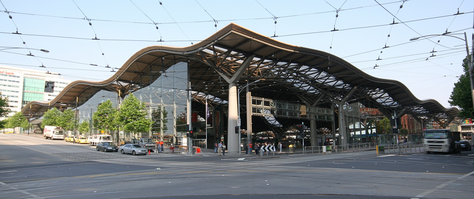
 Docklands' Southern Cross Railway Station from Spencer Street in the Melbourne City Centre
Docklands has access to road transport, rail transport and water transport.
Docklands Highway and Wurundjeri Way are the main roads going through Docklands. These connect to the nearby Westgate Freeway on the southern end. Links to the CBD include extensions from Flinders Street, Collins Street and Latrobe Street.
Southern Cross Station, at the eastern edge is the only passenger railway station, although it is also the major interchange for metropolitan and intercity rail. Much of Docklands area remains covered by rail yards previously used for freight transport and rolling stock which are being progressively reclaimed or built over.
Trams in Docklands include the free City Circle Tram, along Docklands Drive and to and from Waterfront City. As Docklands has developed, tram routes have been extended and rerouted into the area. Route 70 also runs to Waterfront City. Route 48 runs along Collins Street to Victoria Harbour. Route 30 enters Docklands via Latrobe Street, terminating at the north end of Harbour Esplanade. Route 86 runs along Latrobe Street and Docklands Drive, terminating at Waterfront City.
Docklands also includes major pedestrian links with a concourse extending from Bourke Street and extensive promenades along the waterfront including the wide Harbour Esplanade.
Several offroad bicycle paths run through Docklands, all of which connect through the central spine of Webb Bridge, Docklands park and Harbour Esplanade, connecting Melbourne City Centre to the inner western suburbs and the Capital City Trail.
There are also three ferry terminals which connect Docklands to the Melbourne City Centre and inner bayside suburbs. One at Victoria Harbour, one at New Quay and one at Yarra's Edge.
Proposed tram line to Footscray
The Melbourne City Council first proposed extending Route 86 from the Docklands along Footscray Road to Footscray station in 2004. The proposal was to be grade separated along almost the entire length of Footscray Road.
The extension became part of the official Inner Melbourne Action Plan adopted by the Cities of Melbourne, Stonnington, Port Phillip and Yarra in December 2005 as a "long term" goal.[26]
Since 2007 plans have progressed, with the City of Melbourne attempting to source funding.[27]
In response to the Eddington Plan in July 2008, the City of Melbourne included a request for consideration as a key East-West transport solution.[28]
The Victorian Greens also included the route in its 'The People Plan' election proposal.
However the proposal it suffered a setback in late 2008 when it met State Government opposition. The Department of Infrastructure recommended the removal of the Footscray Road reservation to reduce the cost of constructing a overpass to ease congestion on the CityLink freeway off-ramp. The State Government's plan was rejected by the City of Melbourne who passed the flyover project in council on the provision that it would retain the light-rail reservation, at additional State Government expense whilst also adding to the future cost of the tram link.
Demographics and industry
Docklands residents are almost solely housed in high density housing.
In 2009, there were just under 10,000[29] working mostly in office and retail industries.
Notable residents
- Sam Newman[30]
- Troy de Haas (athlete)[citation needed]
Local media
The precinct has two publications, Docklands Community News (DCN) and 3008 Docklands Magazine.
The Docklands Community News' first edition was published in 2003, and both DCN & 3008 Docklands Magazine have grown with the Docklands precincts' population. Both publications are printed and distributed to all businesses and residences within Docklands, which allows for a regular readership of over 10,000. The DCN paper informs the community of relevant news relating to Docklands, also supplying residents, business owners and workers with a platform for community discussion.
3008 Docklands Magazine also covers all matters relating to the Docklands community and businesses but also covers events and news pertaining to Melbourne City and the surrounding suburbs as Docklands is under the jurisdiction of the City of Melbourne. 3008 Docklands Magazine is a glossy, well produced, stylish publication which is both informative and interesting and has been well received by its reader base since its first issue back in May 2006. 3008 Docklands Magazine has a significant online following.
Response and reception
The planning of Docklands has raised a large amount of public debate and the area has created significant controversy, particularly the failed Ferris wheel.[31]
In 1999, Melbourne City Council Director of Projects criticised the disconnection of the precinct to the CBD, claiming that the lack of transport links, particularly pedestrian meant Docklands was "seriously flawed".[32]
The problem was exacerbated in 2005, when the pedestrian link between Lonsdale Street and Docklands proposed in 2001[33] was cut from the final design design of Southern Cross Station development due to budget blowouts.
In 2006, Royce Millar of The Age referred to it as a "wasted opportunity".[6]
In 2008, the City of Melbourne released a report which criticised Docklands lack of transport and wind tunnel effect, lack of green spaces and community facilities.[34][35]
In 2009, Neil Mitchell wrote for The Age declaring Docklands as a planning "dud".[7] The Lord Mayor Robert Doyle has been openly critical of Docklands, claiming in 2009 that it lacks any form of "social glue".[8]
However despite the local criticism in 2009, Sydney travel writer Mal Chenu described Melbourne Docklands as "the envy of Sydneysiders".[36]
In 2010, VicUrban's general manager David Young acknowledged that Harbour Esplanade "doesn't stack up".[37] Kim Dovey, professor of architecture and design at the University of Melbourne added that Harbour Esplanade was "too big" and claimed that Docklands was "so badly done" that it required a "major rethink".[37]
Panoramas
 A panoramic view of Docklands and the city skyline from Waterfront City looking across Victoria Harbour. Features include (from left), some residential and commercial buildings along the harbour at New Quay, the Seven Network digital broadcast centre, some of the original (now renovated) Melbourne docks sheds on Central Pier, the Etihad Stadium, the Victoria Point apartments, and the colourful lowrise National Australia Bank headquarters. In the background is the Melbourne CBD skyline, including the Rialto Towers and the Eureka Tower. The construction in progress of some buildings in Docklands shows the still evolving nature of this part of the city.
 Docklands as seen from Yarra's Edge at night in 2005
.
References
- ^ Australian Bureau of Statistics (25 October 2007). "Docklands (State Suburb)". 2006 Census QuickStats. http://www.censusdata.abs.gov.au/ABSNavigation/prenav/LocationSearch?collection=Census&period=2006&areacode=SSC21229&producttype=QuickStats&breadcrumb=PL&action=401. Retrieved 2007-09-26.
- ^ a b Tomazin, Farrah; Donovan, Patrick; Mundell, Meg (7 December 2002). "Dance trance". Age. Fairfax. http://www.theage.com.au/articles/2002/12/07/1038950203557.html.
- ^ CBRE report pointing to Melbourne Docklands outperforming all other Australian office markets
- ^ Draper, Michelle (28 September 2006). "ANZ deal sparks Docklands concern". Age. Fairfax. http://www.theage.com.au/news/business/anz-deal-sparks-docklands-concern/2006/09/27/1159337223011.html. Retrieved 18 December 2010.
- ^ Johnston, Matt (3 September 2009). "Docklands to get more parkland, 1000 more homes in $1b project". Herald Sun. News Limited. http://www.news.com.au/heraldsun/story/0,21985,26020427-661,00.html. Retrieved 18 December 2010.
- ^ a b Millar, Royce (17 June 2006). "Docklands a wasted opportunity?". Age. Fairfax. http://www.theage.com.au/articles/2006/06/16/1149964737944.html.
- ^ a b [dead link] "dead link". Herald Sun. News Limited. http://www.news.com.au/heraldsun/story/0,21985,25241984-5000117,00.html[dead link]. }}
- ^ a b Dowling, Jason; Lahey, Kate (16 March 2009). "Doyle call for council to take on Docklands". Age. Fairfax. http://www.theage.com.au/national/doyle-call-for-council-to-take-on-docklands-20090315-8yyr.html.
- ^ http://www.architecturemedia.com/aa/aaissue.php?issueid=199809&article=11&typeon=3
- ^ a b c d e f g Dovey, Kim (2005). Fluid City: Transforming Melbourne's Waterfront. Sydney: University of New South Wales Press.
- ^ Equiset.com.au
- ^ Melbourneopenhouse.org
- ^ Melbourneopenhouse.org
- ^ Goxcollection.org.au
- ^ Millar, Royce (2 August 2007). "Visionary architect set to transform Docklands". Age. Fairfax. http://www.theage.com.au/news/national/architect-to-transform-docklands/2007/08/01/1185647977807.html. Retrieved 18 December 2010.
- ^ Craig, Natalie (13 December 2007). "New Age building revealed". Age. Fairfax. http://www.theage.com.au/news/general/iagei-set-for-hightech-new-home/2007/12/13/1197135597809.html.
- ^ Walker Corporation - Recent News
- ^ Microsoft Word - COM_SERVICE_PROD-#4241814-v2-AUG07_DMPC_COMMUNITY_AND_INFR
- ^ Docklands
- ^ Docklands
- ^ Digital Harbour - latest news
- ^ www.docklands.com.au
- ^ HQ NewQuay: Lots 5 & 9
- ^ NewQuay Docklands - "The Avenues at NewQuay" Melbourne's Multi-Million Dollar Waterside Housing Precinct: Melbourne's inner-city waterfront precinct
- ^ Marina Avenue & Parkside Avenue
- ^ http://www.melbourne.vic.gov.au/opm/bc/CTEE/meetings/DMPC_52_200708070430.pdf
- ^ Lucas, Clay (2 January 2008). "Vision for 'friendlier' Docklands". The Age. http://www.theage.com.au/articles/2008/01/01/1198949817058.html?page=fullpage#contentSwap1. Retrieved 2008-07-19.
- ^ http://www.melbourne.vic.gov.au/rsrc/PDFs/Transport/EastWestLink.pdf
- ^ Docklands.com
- ^ http://www.heraldsun.com.au/sport/sam-newman-gives-skateboarders-a-tongue-lashing/story-e6frf9if-1111115355715
- ^ ABC.net.au
- ^ ABC.net.au
- ^ DPC.vic.gov.au
- ^ Lucas, Clay (2 January 2008). "Vision for 'friendlier' Docklands". Age. Fairfax. http://www.theage.com.au/articles/2008/01/01/1198949817058.html. Retrieved 18 December 2010.
- ^ Melbourne.vic.gov.au
- ^ Chenu, Mal (6 August 2009). "Cows, cranes and goalposts". Sydney Morning Herald. Fairfax. http://www.smh.com.au/travel/cows-cranes-and-goalposts-20090723-duy5.html?page=-1. Retrieved 18 December 2010.
- ^ a b Cooke, Dewi (17 March 2010). "Docklands $9bn plan for next decade". Age. Fairfax. http://www.theage.com.au/victoria/docklands-9bn-plan-for-next-decade-20100316-qckx.html. Retrieved 18 December 2010.
Further reading
- Kim Dovey: Fluid City: Transforming Melbourne's Urban Waterfront, London: Routledge, 2005
External links
- Official website
- 3008 Docklands Magazine Website
- Docklands Community News
- NewQuay website
- Waterfront City website
- Victoria Harbour website
- Yarra's Edge website
- Digital Harbour website
- Victoria Online - Docklands Authority
- Australian Places - Docklands
- How public is your private? Article about Docklands by Martin Musiatowicz
Coordinates: 37°49′18″S 144°56′50″E / 37.8218°S 144.94736°E
Suburbs of the City of Melbourne | Melbourne | Victoria Carlton · Carlton North · Docklands · East Melbourne · Flemington · Kensington · Melbourne CBD · North Melbourne · Port Melbourne · Parkville · Southbank · South Wharf · South Yarra · West Melbourne
Categories:- Landmarks in Melbourne
- Geography of Melbourne
- Suburbs of Melbourne
- Planned communities
- Redeveloped ports and waterfronts
- Docks
- Waterfronts
- Yarra River
- 2006 Commonwealth Games venues
-


Wikimedia Foundation. 2010.