- Napier, New Zealand
-
Napier
Ahuriri (Māori)View of Napier on Hawke's Bay Location of Napier
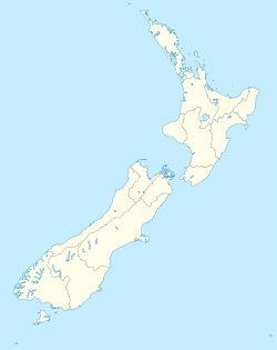
 Napier
Coordinates: 39°29′S 176°55′E / 39.483°S 176.917°ECoordinates: 39°29′S 176°55′E / 39.483°S 176.917°E Country  New Zealand
Region Hawke's Bay Territorial authority Napier City Government - Mayor Barbara Arnott Area - Territorial 106 km2 (40.9 sq mi) Population (June 2010 estimate)[1] - Territorial 57,600 - Urban 58,600 Time zone New Zealand Standard Time (UTC+12) - Summer (DST) New Zealand Daylight Time (UTC+13) Area code(s) 06 Website www.Napier.govt.nz Napier (called Ahuriri in the Māori language) is a New Zealand city with a seaport, located in Hawke's Bay on the eastern coast of the North Island. The population of Napier is about 58,600 as of the June 2010 estimate.[1] About 18 kilometres south of Napier is the inland city of Hastings. These two neighboring cities are often called "The Twin Cities" or "The Bay Cities" of New Zealand. The total population of the metropolitan area of Napier and Hastings is about 122,600 people, which makes Napier-Hastings the fifth-largest metropolitan area in New Zealand, closely followed by Tauranga (pop. 116,000), and Dunedin (pop. 115,000), and trailing Hamilton (pop. 203,400).
Napier is about 320 kilometres northeast of the capital city of Wellington. Napier has a population smaller than Hastings but is seen as the main centre due to it having both the seaport and the airport, although Hastings has a small aerodrome.
Napier is the nexus of the largest wool centre in the Southern Hemisphere, and it has the primary export seaport for northeastern New Zealand – which is the largest producer of apples, pears, and stone fruit in New Zealand. Napier has also become an important grape and wine production area, with the grapes grown mostly around Hastings being sent through the Port of Napier for export. Large amounts of sheep's wool, frozen meat, wood pulp, and timber also pass through Napier annually for export. Of course, smaller amounts of these materials are shipped via lorry and railway to the large metropolitan areas of New Zealand itself, such as Auckland, Wellington and Hamilton.
Napier is a popular tourist city, with a unique concentration of 1930s Art Deco architecture. It also has one of the most photographed tourist attractions in the country, a statue on Marine Parade called Pania of the Reef. Thousands of people flock to Napier every February for the Art Deco Weekend event, a celebration of its Art Deco heritage and history. Other notable tourist events attracting many outsiders include the region's annual Wine & Food Festival (named Harvest Hawke's Bay), and Mission Concert at the Mission Estate Winery in the nearby township of Taradale.
Contents
History
Māori history
Napier has well-documented Māori history. When the Ngāti Kahungunu party of Taraia reached the district many centuries ago, the Whatumamoa, Rangitane and the Ngāti Awa and elements of the Ngāti Tara iwi existed in the nearby areas of Petane, Te Whanganui-a-Orotu and Waiohiki. Later, the Ngāti Kahungunu became the dominant force from Poverty Bay to Wellington. They were one of the first Māori tribes to come in contact with European settlers.
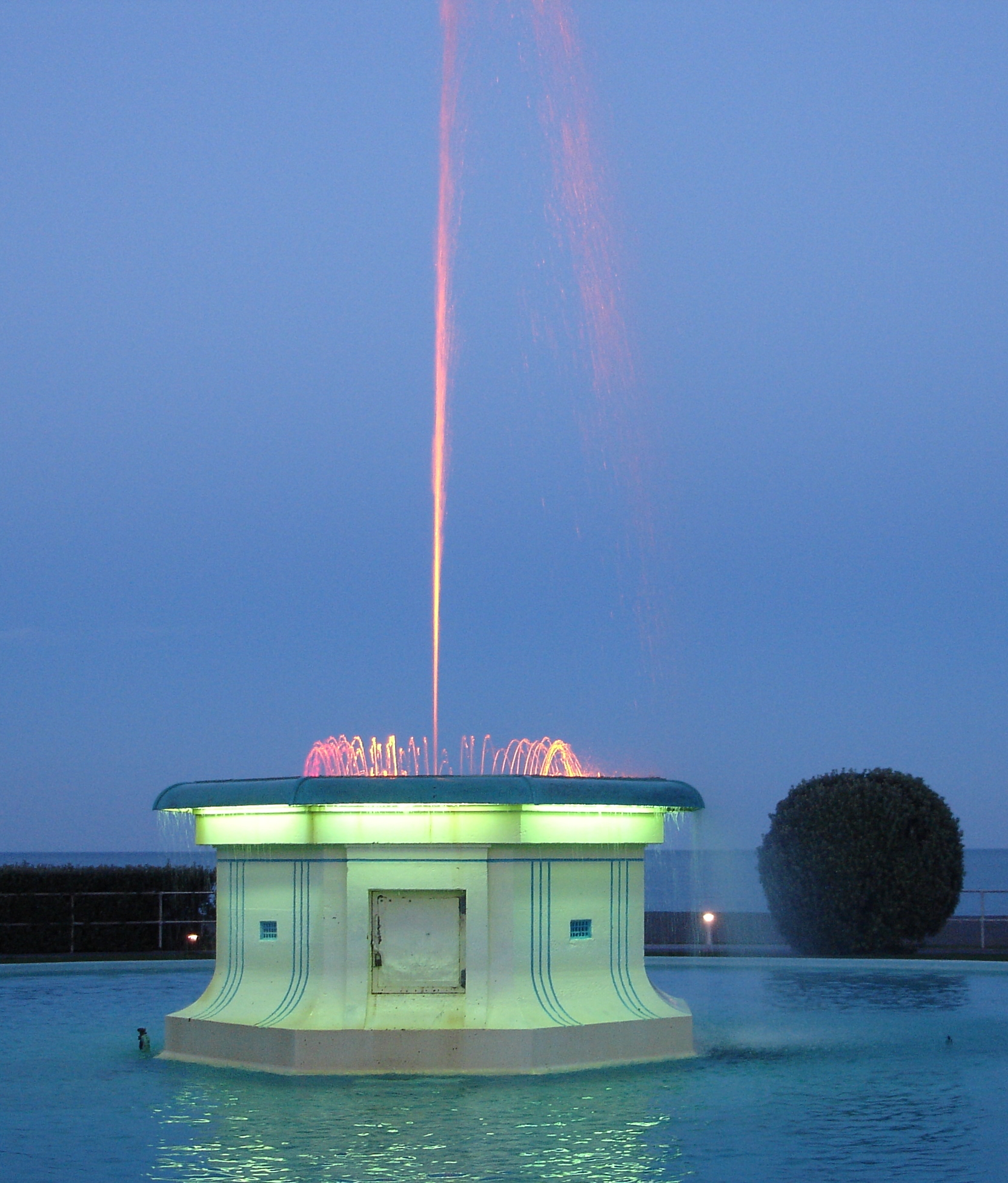
 Napier's Tom Parker Fountain at dusk
Chief Te Ahuriri cut a channel into the lagoon space at Ahuriri because the Westshore entrance had become blocked, threatening cultivations surrounding the lagoon and the fishing villages on the islands in the lagoon. The rivers were continually feeding freshwater into the area.
European settlers' history
The first European to see the future site of Napier was Captain James Cook, who sailed down the east coast in October 1769. He commented: "On each side of this bluff head is a low, narrow sand or stone beach, between these beaches and the mainland is a pretty large lake of salt water I suppose." [2] He said the harbour entrance was at the Westshore end of the shingle beach. The site was subsequently visited and later settled by European traders, whalers and missionaries. By the 1850s, farmers and hotel-keepers arrived.
 Sound Shell (1931) in Napier at night.
The Crown purchased the Ahuriri block (including the site of Napier) in 1851. In 1854 Alfred Domett, a future Prime Minister of New Zealand, was appointed as the Commissioner of Crown Lands and the resident magistrate at the village of Ahuriri. It was decided to place a planned town here, its streets and avenues were laid out, and the new town named for Sir Charles Napier, a military leader during the "Battle of Meeanee" founght in the province of Sindh, India. Mr. Domett named many streets in Napier to commemorate the colonial era of the British Indian Empire.[2]
Napier was designated as a borough in 1874, but the development of the surrounding marshlands and reclamation proceeded slowly. Between 1858 and 1876 Napier was the administrative centre for the Hawke's Bay Province, but in 1876 the "Abolition of Provinces Act", an act of the Parliament of New Zealand, dissolved all provincial governments in New Zealand.[2]
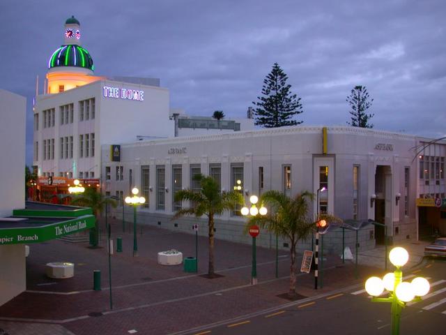
 T & G Dome at dusk
 Halsbury Chambers (Louis Hay, 1932), Napier
Development was generally confined to the hill and to the port area of Ahuriri. In the early years, Napier covered almost exclusively an oblong group of hills (the Scinde Island) which was nearly entirely surrounded by the ocean, but from which ran out two single spits, one to the north and one to the south. There was a swamp between the now Hastings Street and Wellesley Road and the sea extended to "Clive Square".
1931 earthquake
Main article: 1931 Hawke's Bay earthquakeOn February 3, 1931, most of Napier was levelled by an earthquake. The collapses of buildings and the ensuing fires killed 256 people. The centre of the town was destroyed by the earthquake, and later rebuilt in the Art Deco style popular at that time. Some 4000 hectares of today's Napier were undersea before the earthquake raised it up above sea level.[2]
Although a few Art Deco buildings were replaced with contemporary structures during the 1960s, 1970s, and 1980s, most of the centre remained intact for long enough to become recognized as architecturally important, and beginning in the 1990s it had been protected and restored. Napier and the area of South Beach, Miami, Florida, are considered to be the two best-preserved Art Deco towns (with the town of Miami Beach, Florida, being mostly decorated in the somewhat later Streamline Moderne style of Art Deco.)
Beginning in 2007, Napier was nominated as a World Heritage Site with UNESCO. This is the first cultural site in New Zealand to be so nominated.[3]
Modern history
In January 1945, the German Kriegsmarine U-boat (submarine) U-862 entered and departed from the port of Napier undetected. This event became the basis of a widely-circulated postwar tall tale that the captain of this U-boat, Heinrich Timm, had led crewmen ashore near Napier to milk cows in order to supplement their meagre rations.
Napier Hill was the scene of a police siege of an armed criminal in May 2009, with one police officer and the gunman being killed; and two police officers and one member of the public being wounded.[4]
Geography and Climate
The town is on the Bluff Hill headland and the surrounding plain at the southeastern edge of Hawke Bay, a large semi-circular bay that dominates the east coast of New Zealand's North Island. The coastline of the town was substantially altered by a large earthquake in 1931. The topography puts Napier in danger from a tsunami, as the centre of the commercial city is near sea level – should the sea ever crest Marine Parade the sea would run through to Ahuriri.[citation needed]
Several smaller towns lie close to the city; the closest is Taradale, the location of some of the region’s oldest established wineries. Other surrounding towns include Bay View, to the north, Clive, to the south, Flaxmere, west of Hastings, and Havelock North. As a territorial authority, Napier City is surrounded by the much larger Hastings District.
The city enjoys some of the highest sunshine hours in New Zealand. The climate is warm and relatively dry resulting from its location on the east coast of the North Island. Most of New Zealand's weather patterns cross the country from the west, and the city lies in the rain shadow of the North Island Volcanic Plateau and surrounding ranges such as the Kaweka Range. However, the city is prone to the remnants of tropical cyclones from the central Pacific Ocean, which are occasionally still at storm strength by the time that they have reached Hawke's Bay.[citation needed]
Climate data for Napier Month Jan Feb Mar Apr May Jun Jul Aug Sep Oct Nov Dec Year Average high °C (°F) 24.4
(75.9)24.1
(75.4)22.6
(72.7)19.9
(67.8)17.1
(62.8)14.5
(58.1)14.1
(57.4)14.8
(58.6)16.9
(62.4)19.2
(66.6)21
(70)23
(73)19.4 Average low °C (°F) 14.6
(58.3)14.5
(58.1)12.8
(55.0)10.2
(50.4)7.1
(44.8)4.9
(40.8)4.6
(40.3)5.2
(41.4)7.1
(44.8)9.4
(48.9)11.2
(52.2)13.4
(56.1)9.6 Precipitation mm (inches) 48
(1.89)62
(2.44)85
(3.35)75
(2.95)62
(2.44)81
(3.19)92
(3.62)67
(2.64)65
(2.56)55
(2.17)57
(2.24)56
(2.2)803
(31.61)% humidity 68 73 74 77 77 81 80 77 70 67 66 66 73 Avg. precipitation days 6 6 8 8 7 9 9 9 9 7 6 6 90 Sunshine hours 242 201 193 163 153 124 138 159 172 208 213 232 2,188 Source: NIWA Climate Data[5] Demographics
At the 2006 census, Napier had a population of 55,359, an increase of 1698 people, or 3.2 percent, since the 2001 census. There were 21,756 occupied dwellings, 1326 unoccupied dwellings, and 150 dwellings under construction.[6]
Of the population of Napier, 26,520 (47.9 percent) were male, and 28,839 (52.1 percent) were female. The city had a median age of 38.6 years, 2.7 years above the national median age of 35.9 years. People aged 65 years and over made up 15.6 percent of the population, compared to 12.3 percent nationally, and people under 15 years made up 21.2 percent of the population, compared to 21.5 percent nationally.[6]
Napier's ethnicity was made up of (national figure in brackets): 72.4 percent European (67.6 percent), 18.2 percent Maori (14.7 percent), 2.6 percent Asian (9.2 percent), 2.6 percent Pacific Islanders (6.9 percent), 0.4 percent Middle Eastern/Latin American/African (0.9 percent), 14.3 percent 'New Zealanders' (11.1 percent), and 0.03 percent Other (0.04 percent).[6]
Napier had an unemployment rate of 4.8 percent of people 15 years and over, compared to 5.1 percent nationally. The average annual income of all people 15 years and over in Napier was $22,700, compared to $24,400 nationally. Of those, 45.2 percent earned under $20,000 annually, compared to 43.2 percent nationally, while 14.5 percent earned over $50,000 annually, compared to 18.0 percent nationally.[6]
Tourism and Architecture
Napier's major tourist attraction is its architecture, which draws Art Deco and architecture enthusiasts from around the world. The rebuilding period after the 1931 earthquake coincided with the short-lived and rapidly changing Art Deco era and the Great Depression, when little "mainstreet" development was being undertaken elsewhere. As a result Napier's architecture is strikingly different from any other city; the other notable Art Deco city, Miami Beach, has Streamline Moderne Art Deco. The whole centre of Napier was rebuilt simultaneously.
 The T & G Building (Atkin & Mitchell, Wellington, 1936)
Other tourist attractions in Napier include The Hawke's Bay Museum and Art Gallery which features information on both the 1931 earthquake and Napier's redesign as an Art Deco city, the National Aquarium, the Soundshell and the Pania of the Reef statue. The Pania statue on Marine Parade is regarded in Napier in much the same way that the Little Mermaid statue is regarded in Copenhagen. In October 2005 the statue was stolen, but it was recovered a week later, largely unharmed.[7] Marineland was a tourist attraction from 1965 until it closed in 2009.[8] Tourists flock to Napier in February for Art Deco weekend and the Mission Concert Weekend in nearby Taradale which has featured Chris De Burgh, Olivia Newton-John, Eric Clapton, Kenny Rogers, Ray Charles, Rod Stewart and most recently (2011) Sting performing with the NZ Symphony Orchestra.
Attractions nearby include the Cape Kidnappers Gannet Colony and many vineyards bordering Taradale, Hastings City, and north of Napier around Bay View and the Esk Valley. The large wine industry hosted the Annual Harvest Hawkes Bay Weekend until 2010. This has now changed its name to Hawke's Bay Wine & Food Festival and is at a centralised venue in Roys Hill.
Many people use Napier as a gateway to Hawke's Bay, flying in to Hawke's Bay Airport at Westshore from Wellington City, Auckland and Christchurch. Tourists also enter Napier by State Highway 2 along the coast and State Highway 5 from Taupo. The rail line in and out of Hawke's Bay has not had a passenger service since 2001.
Economy
The largest industry in Napier and its environs is processing/manufacturing, the major products being food, textiles, wood, metal products and machinery/equipment.[9] Other significant industries for the region include property/business services, rural production/rural services and retail.[10]
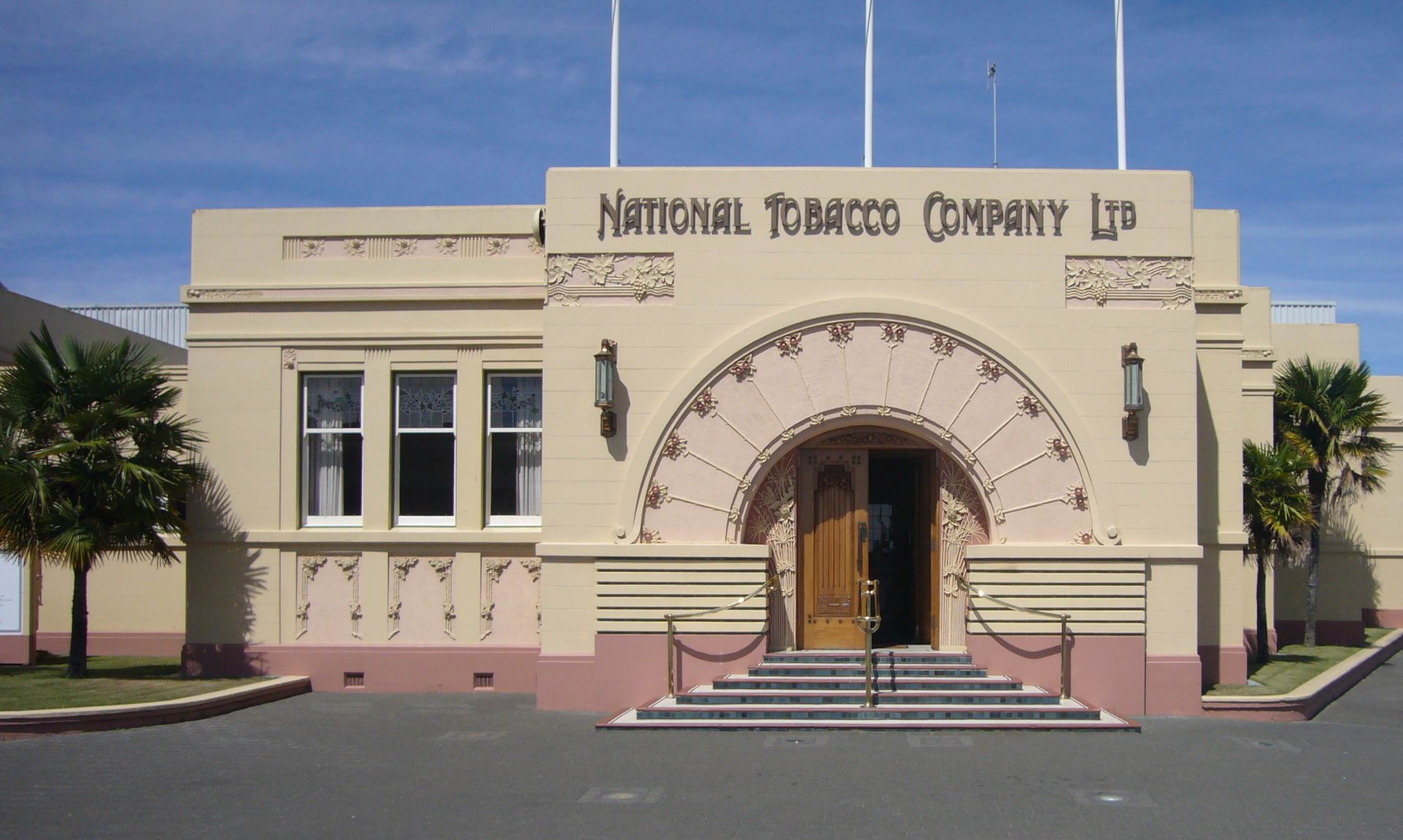
Napier was once home to one of New Zealand's largest smoking tobacco plants. On 9 September 2005 British American Tobacco announced it would close the Rothmans factory, due to diminished demand. Production has moved to Australia. The Art Deco-style factory had been producing up to 2.2 billion cigarettes a year for the New Zealand and Pacific Island markets.[citation needed] In March 1999, 19 people lost their jobs there because "fewer people are smoking".[11]
 View of Napier and Taradale from Sugar Loaf (behind Mission Winery)
Napier suffered a double blow from service amalgamation towards the end of the century. The local newspaper, the (Napier) Daily Telegraph, was combined with the (Hastings) Herald-Tribune to form a new regional newspaper Hawke's Bay Today. The Napier offices were closed down in favour of locating the offices in Hastings. The next rationalization saw the closure of the Napier Hospital, and the services were amalgamated with the Hastings Hospital creating the Hawke's Bay Regional Hospital located on the Hastings site.
Local government reform was mooted in the late 1990s and a referendum was held in 1999 proposing an amalgamation of the Hastings District Council with the Napier City Council. Although supported by approximately two thirds of Hastings voters, Napier voters rejected the proposal by a similar number and the proposal was defeated. The Mayor of Hastings, Lawrence Yule, has announced he will be standing for Mayor again in 2010 on the platform of local authority amalgamation.
Culture and Entertainment
 Veronica Sunbay overlooking the sea on Marine Parade
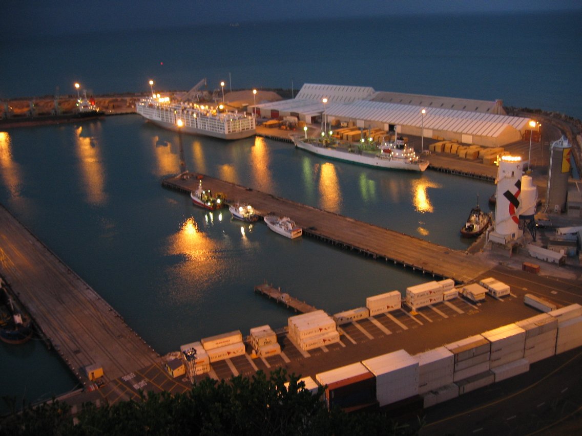
 Port of Napier at night
Napier prides itself as the 'Art Deco Capital'. Its Mediterranean climate supports a vibrant cafe culture, and excellent cuisine. Wine is also important in the whole Hawke's Bay region which is renowned for producing some of the world's finest wines with over 70 wineries located in the area. The region is also New Zealand's largest apple, pear and stone fruit producer. The Port of Napier and rail network provides quick export of these goods.
Entertainment in Napier is vibrant and varied. Tourists flock to the city for its attractions and activities, and a large attraction is the Art Deco building designs. Marine Parade is one of Napier's most famous highlights - a tree-lined ocean boulevard with fountains, gardens, mini golf, statues and spas. [12] The National Aquarium of New Zealand is also located on Marine Parade. For a city of its size, Napier also has a rather large number of hotels and accommodation providers compared to other New Zealand cities of similar size. Napier has a lively entertainment scene that includes many outdoor and indoor activities such as city tours, swimming, golf, sports, restaurants, theatres, etc. Shopping is also popular - there are high street and boutique stores to browse in, as well as antique shops, art galleries, and studios of potters, wood turners and craftsman. [13]
 Spirit of Napier, or Gilray Fountain, along Marine Parade
There is also a thriving nightlife present in Napier. This is especially present in the entertainment district of Ahuriri, located five minutes drive from the city centre, along West Quay and Nelson Quay. Tourists and locals alike also enjoy walking or driving along Marine Parade after sunset. Local bands can be found playing in bars and restaurants. Local bands include the post rock group Jakob.
Sailing, fishing and other water activities in the Bay are also popular. The marina and waterfront in Ahuriri, Napier, is a popular sea-tourism attraction. Fishing industries are thriving in Napier. On hot "Hawke's Bay days" swimming and family activities are popular in Pandora Pond - a salt water inlet by the inner harbour in Ahuriri - or on the beaches and playgrounds of Westshore by the Port.
Schools and higher education
Further information: List of schools in Hawke's Bay, New Zealand#Napier CityThe Eastern Institute of Technology is the main tertiary education provider for Napier.
Notable residents
- Rita Angus – painter
- Mike Boon – comedian
- Chris Jackson – Former New Zealand international and Napier City Rovers association football player
- Spencer Gollan – sportsman and racehorse owner
- Debbie Harwood – singer with When The Cat's Away
- Paul Henare - Basketball player for the New Zealand Breakers and Tall Blacks
- Simon Mannering – New Zealand Warriors rugby league player and captain
- Paratene Matchitt – artist
- Stuart Nash – politician
- Blair Peach – political activist
- John Psathas – composer
- Darren Smith – field hockey player
- Chris Tremain – politician
- Kel Tremain – former rugby player
- Percy Valentine Storkey – soldier and Victoria Cross winner
- Alec Wishart – Lead singer of band Hogsnort Rupert
- Rosanagh Wypych - Contestant of New Zealand's Next Top Model
Sister cities
References
- ^ a b "Subnational population estimates at 30 June 2010 (boundaries at 1 November 2010)". Statistics New Zealand. 26 October 2010. http://www.stats.govt.nz/~/media/Statistics/Methods%20and%20Services/Tables/Subnational%20population%20estimates/subpopest2001-10.ashx. Retrieved 7 March 2011.
- ^ a b c d History Napier and Taradale – Napier City – Hawke's Bay – New Zealand
- ^ Napier Art Deco historic precinct – UNESCO World Heritage Centre
- ^ "Napier shooting: Siege over as Molenaar's body located". The New Zealand Herald. 9 May 2009. http://www.nzherald.co.nz/nz/news/article.cfm?c_id=1&objectid=10571362. Retrieved 2009-05-09.
- ^ "Climate Data". NIWA. http://www.niwascience.co.nz/edu/resources/climate/. Retrieved November 2, 2007.
- ^ a b c d Quickstats about Napier City
- ^ "Pania statue found". The New Zealand Herald. 4 November 2005. http://www.nzherald.co.nz/topic/story.cfm?c_id=344&objectid=10353607.
- ^ "End of an era as Napier's Marineland closes". The New Zealand Herald. Newstalk ZB. 27 April 2009. http://www.nzherald.co.nz/travel/news/article.cfm?c_id=7&objectid=10568846. Retrieved 27 October 2011.
- ^ Napier City Economic and Tourism Update 16 March 2011 Retrieved 2011-03-31.
- ^ Napier City Economic Trends and Outlook March 2010 Update Report Retrieved 2011-03-31.
- ^ July 1999 decisions
- ^ http://www.hawkesbaynz.com/Visit/abouthawkesbay/Regions/Napier/
- ^ http://www.hawkesbaynz.com/Visit/abouthawkesbay/Regions/Napier/
External links
- City of Napier
- Napier, New Zealand's Art Deco City
- Hawke's Bay Tourism
- Napier Street Map
- Napier Local and Tourist Information
 New Zealand topics
History 
Geography Time zones · Environment · National Parks · Marine reserves · Islands · Lakes · Rivers · Caves · Cities · Towns · BiodiversityGovernance Politics Economy Society Culture Māori culture · Māori language · NZ English · Art · Cinema · Kiwi (people) · Literature · Music · Sport · Public holidaysMain cities Wellington (capital) · Auckland (largest) · Christchurch · Hamilton · Dunedin · Tauranga · Napier-Hastings · Palmerston North Book ·
  Category ·
  Portal ·
  WikiProjectCategories:
- Main urban areas in New Zealand
- Hawke's Bay Region
- Art Deco
- Port cities in New Zealand
- Napier, New Zealand


Wikimedia Foundation. 2010.