- Clarke County, Virginia
-
Clarke County, Virginia 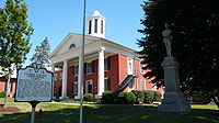 Clarke County Courthouse in Berryville, Virginia
Seal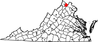
Location in the state of Virginia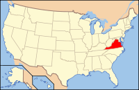
Virginia's location in the U.S.Founded 1836 Seat Berryville Area
- Total
- Land
- Water
178 sq mi (461 km²)
176 sq mi (456 km²)
2 sq mi (5 km²), 0.88%Population
- Density
14,034
73/sq mi (28/km²)Website www.co.clarke.va.us Clarke County is a county in the Commonwealth of Virginia. As of 2010, the population was 14,034.[1] Its county seat is Berryville[2].
Contents
History
Clarke County was established in 1836 by Thomas Fairfax, 6th Lord Fairfax of Cameron who built a home, Greenway Court, on part of his 5 million acre (20,000 km²) property, near what is now the village of White Post. White Post was named for the large signpost pointing the way to Lord Fairfax's home.
Many of the early settlers of what became Clarke County were children of Tidewater planters, who settled on large land grants from Lord Fairfax. 2/3 of the county was settled by the plantation group, and the plantation lifestyle thrived until the Civil War. Clarke was known for its large crops of wheat.
During the Civil War, John S. Mosby, "the Gray Ghost" of the Confederacy, raided General Sheridan's supply train in the summer of 1864, in Berryville. The Battle of Cool Spring was fought in Clarke County on July 17 and 18th, 1864, and the Battle of Berryville on September 3, 1864.
Early in the 20th century, future Virginia politician Harry F. Byrd, Sr. and his wife established their first home near Berryville, where he undertook extensive agricultural activity growing peaches and apples. Byrd became a State senator in the upper house of the Virginia General Assembly, served a term as a Governor of Virginia, and was a United States Senator for over 30 years, heading the powerful Byrd Organization which dominated state politics between the mid 1920s and 1960s.
Historic Buildings and Structures
- Clermont Estate (1751)
- Fairfield (1765)
- Soldier's Rest (1769)
- Buck Marsh Church (1772)
- Norwood (1780)
- Burwell-Morgan Mill (1782)
- Holy Cross Abbey (1784)
- Audley Estate (1794)
- Bel Voi (1803)
- Rosemont Estate (1811)
- Clay Hill (1816)
- Clifton (1833)
- Clarke County Courthouse (1837)
- Stone's Chapel (1848)
- Glendale Farm (1850)
- Site of Mosby's Raid (1863)
Photo Gallery
-

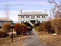
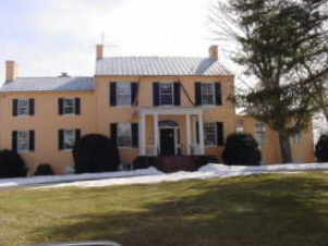
Fairfield Estate (1765)
-

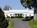
Soldier's Rest (1769)
-

Norwood Estate (1780)
-
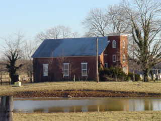
Holy Cross Abbey (1784)
-
Audley Estate (1794)
-

Bel Voi (1803)
-

Rosemont Estate (1811)
-

Clay Hill (1816)
-

Clifton (1833)
-

Clarke County Courthouse (1837)
-

Stone's Chapel (1848)
-

Glendale Farm (1850)
Google Earth Placemarks
- Clermont Estate
- Fairfield
- Soldier's Rest
- Norwood Estate
- Buck Marsh Church
- Holy Cross Abbey
- Stone's Chapel
- Audley Estate
- Bel Voi
- Rosemont Estate
- Clay Hill
- Clifton Estate
- Clarke County Courthouse
- Glendale Farm
- Site of Mosby's Raid in Berryville
Geography
According to the U.S. Census Bureau, the county has a total area of 178 square miles (461.0 km2), of which 177 square miles (458.4 km2) is land and 2 square miles (5.2 km2) (0.88%) is water.
Adjacent counties
- Loudoun County, Virginia - East
- Warren County, Virginia - South West
- Fauquier County, Virginia - South East
- Frederick County, Virginia - West
- Jefferson County, West Virginia - North
Demographics
Historical populations Census Pop. %± 1840 6,353 — 1850 7,352 15.7% 1860 7,146 −2.8% 1870 6,670 −6.7% 1880 7,682 15.2% 1890 8,071 5.1% 1900 7,927 −1.8% 1910 7,468 −5.8% 1920 7,165 −4.1% 1930 7,167 0% 1940 7,159 −0.1% 1950 7,074 −1.2% 1960 7,942 12.3% 1970 8,102 2.0% 1980 9,965 23.0% 1990 12,101 21.4% 2000 12,652 4.6% 2010 14,034 10.9%
As of the census[3] of 2000, there were 12,652 people, 4,942 households, and 3,513 families residing in the county. The population density was 72 people per square mile (28/km²). There were 5,388 housing units at an average density of 30 per square mile (12/km²). The racial makeup of the county was 91.15% White, 6.73% Black or African American, 0.19% Native American, 0.49% Asian, 0.03% Pacific Islander, 0.55% from other races, and 0.85% from two or more races. 1.46% of the population was Hispanic or Latino of any race.By 2005 90.1% of Clarke County's population was non-Hispanic whites. 6.3% were African-American. 0.2% Native American. 0.6% Asian. 2.6% were Latino.
There were 4,942 households out of which 29.40% had children under the age of 18 living with them, 58.20% were married couples living together, 8.90% had a female householder with no husband present, and 28.90% were non-families. 24.10% of all households were made up of individuals and 9.90% had someone living alone who was 65 years of age or older. The average household size was 2.50 and the average family size was 2.97.
In the county, the population was spread out with 23.40% under the age of 18, 5.80% from 18 to 24, 29.10% from 25 to 44, 27.10% from 45 to 64, and 14.60% who were 65 years of age or older. The median age was 41 years. For every 100 females there were 98.00 males. For every 100 females age 18 and over, there were 96.60 males.
The median income for a household in the county was $51,601, and the median income for a family was $59,750. Males had a median income of $40,254 versus $30,165 for females. The per capita income for the county was $24,844. About 4.20% of families and 6.60% of the population were below the poverty line, including 7.10% of those under age 18 and 11.10% of those age 65 or over.
Transportation
- Shenandoah Valley Commuter Bus Service offers weekday commuter bus service from Northern Shenandoah Valley including Shenandoah County and Warren County to Northern Virginia and Washington, D.C. including Arlington County and Fairfax County. Origination points in Shenandoah County include Woodstock. Origination points in Warren County include Front Royal and Linden.
Towns
Incorporated towns
Unincorporated communities
See also
References
- ^ [1]. Weldon Cooper Center 2010 Census Count Retrieved September 9, 2011
- ^ "Find a County". National Association of Counties. http://www.naco.org/Counties/Pages/FindACounty.aspx. Retrieved 2011-06-07.
- ^ "American FactFinder". United States Census Bureau. http://factfinder.census.gov. Retrieved 2008-01-31.
External links
- Clarke County Official Government Website
- Clarke County Public Schools
- Clarke County Historical Association
- VAGenWeb Clarke County
- Clarke County Fair

Jefferson County, West Virginia Frederick County 
Loudoun County  Clarke County, Virginia

Warren County Fauquier County Municipalities and communities of Clarke County, Virginia Towns 
CDPs Shenandoah Farms‡ | Shenandoah Retreat
Unincorporated
communitiesBerrys | Bethel | Briggs | Castlemans Ferry | Claytonville | Double Tollgate | Frogtown | Gaylord | Greenway Court | Lewisville | Lockes Landing | Lost Corner | Millwood | Pigeon Hill | Pyletown | Saratoga | Stone Bridge | Stringtown | Swimley | Wadesville | Waterloo | Webbtown | White Post | Wickliffe
Footnotes ‡This populated place also has portions in an adjacent county or counties
Categories:- Virginia counties
- Clarke County, Virginia
- Washington metropolitan area
- 1836 establishments in the United States
- Populated places established in 1836


Wikimedia Foundation. 2010.