- National Register of Historic Places listings in Cabarrus County, North Carolina
-
This list includes properties and districts listed on the National Register of Historic Places in Cabarrus County, North Carolina. Click the "Map of all coordinates" link to the right to view a Google map of all properties and districts with latitude and longitude coordinates in the table below.[1]
-
- This National Park Service list is complete through NPS recent listings posted November 10, 2011.[2]
[3] Landmark name[4] Image Date listed Location City or Town Summary 1 Barber-Scotia College February 28, 1985 145 Cabarrus Ave. West
35°24′23″N 80°35′9″W / 35.40639°N 80.58583°WConcord 2 Bethel Church Arbor May 23, 1997 Jct of NC 1123 and NC 1121
35°14′27″N 80°32′12″W / 35.24083°N 80.53667°WMidland 3 Boger-Hartsell Farm July 23, 1998 Jct. of US-801 and NC1148
35°18′53″N 80°31′0″W / 35.31472°N 80.516667°WConcord 4 Bost Mill Historic District January 13, 1986 N and S sides of NC 200 off US 601
35°19′32″N 80°30′8″W / 35.32556°N 80.50222°WGeorgeville 5 Cabarrus County Courthouse June 5, 1974 Union St., S.
35°24′37″N 80°34′52″W / 35.41028°N 80.58111°WConcord 6 Dr. Charles Favoni-Harris and William Shakespeare House March 5, 1986 SR 1445
35°23′24″N 80°43′13″W / 35.39°N 80.72028°WPoplar Tent 7 First Congregational Church January 9, 1986 Corner of Wade and C Sts.
35°23′57″N 80°25′40″W / 35.39917°N 80.42778°WMount Pleasant 8 John Bunyan Green Farm June 2, 1988 SR 1114 .5 miles E of SR 1178
35°12′56″N 80°29′23″W / 35.21556°N 80.48972°WMidland 9 Daniel Isenhour House and Farm April 21, 2000 11970 Mt. Olive Rd.
35°29′51″N 80°22′50″W / 35.4975°N 80.38056°WGold Hill 10 Lentz Hotel June 14, 1982 College St.
35°24′10″N 80°26′14″W / 35.40278°N 80.43722°WMount Pleasant 11 McCurdy Log House January 21, 1974 S of Concord off U.S. 601
35°19′3″N 80°32′32″W / 35.3175°N 80.54222°WConcord 12 Meek House September 24, 2001 NC 1624, 0.3 miles NE of jct. with NC 1622
35°27′40″N 80°40′14″W / 35.46111°N 80.67056°WKannapolis 13 Mill Hill September 10, 1974 W of Kannapolis on SR 1616
35°28′36″N 80°41′59″W / 35.47667°N 80.69972°WConcord 14 Robert Harvey Morrison Farm and Pioneer Mills Gold Mine December 31, 1990 730 Morrison Rd.
35°15′43″N 80°35′13″W / 35.26194°N 80.58694°WMidland 15 Mount Pleasant Collegiate Institute Historic District November 15, 1979 Jct. of NC 49 and NC 73
35°24′8″N 80°26′12″W / 35.40222°N 80.43667°WMount Pleasant 16 Mount Pleasant Historic District May 12, 1986 Roughly W. and E. Franklin between N. Halifax and C and N and N. and S. Main Sts. between Boston and Broad Sts.
35°24′3″N 80°26′6″W / 35.40083°N 80.435°WMount Pleasant 17 North Union Street Historic District April 15, 1986 Roughly bounded by Peachtree Ave. NW, Church St. N, Cobran Ave. SW, and Georgia St. NW and Spring St. N
35°24′46″N 80°35′13″W / 35.41278°N 80.58694°WConcord 18 Odell-Locke-Randolph Cotton Mill March 28, 1983 Buffalo, Church, Peachtree, and Locust Sts.
35°25′6″N 80°35′26″W / 35.41833°N 80.59056°WConcord 19 Harvey Jeremiah Peeler House August 16, 2007 101 S. Ridge Ave.
35°29′50″N 80°37′24″W / 35.49722°N 80.62333°WKannapolis 20 Rev. John E. Pressley House January 6, 1986 N side of SR 1613 0.3 miles E of SR 1612
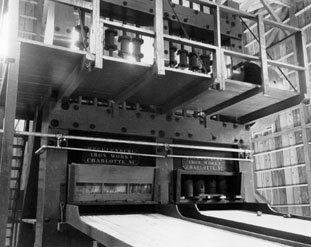
35°30′18″N 80°45′40″W / 35.505°N 80.76111°WBethpage 21 Reed Gold Mine 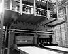
October 15, 1966 11 miles SE of Concord
35°16′52″N 80°27′36″W / 35.28111°N 80.46°WConcord 22 Rocky River Presbyterian Church March 6, 1986 Jct. of NC 1139 and NC 1158
35°18′9″N 80°35′58″W / 35.3025°N 80.59944°WRocky River 23 South Union Street Courthouse and Commercial Historic District September 30, 1997 Along Union St., bounded by Corban and Cabarrus Aves.
35°24′34″N 80°34′49″W / 35.40944°N 80.58028°WConcord 24 South Union Street Historic District April 10, 1986 Roughly bounded by Corban Ave. SW, S. Union St., Blume Ave. SE, and Spring St. SW
35°24′13″N 80°34′30″W / 35.40361°N 80.575°WConcord 25 Spears House August 7, 1989 1615 Morrison Rd.
35°15′14″N 80°36′10″W / 35.25389°N 80.60278°WConcord 26 Stonewall Jackson Training School Historic District 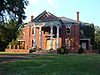
March 15, 1984 SR 1157
35°21′51″N 80°35′54″W / 35.36417°N 80.59833°WConcord 27 Union Street North-Cabarrus Avenue Commercial Historic District December 10, 2003 Roughly Union St. N, Cabarrus Ave. E, Cabarrus Ave. W, and Church St. S
35°24′38″N 80°34′53″W / 35.41056°N 80.58139°WConcord See also
- National Register of Historic Places listings in North Carolina
- List of National Historic Landmarks in North Carolina
References
- ^ The latitude and longitude information provided in this table was derived originally from the National Register Information System, which has been found to be fairly accurate for about 99% of listings. For about 1% of NRIS original coordinates, experience has shown that one or both coordinates are typos or otherwise extremely far off; some corrections may have been made. A more subtle problem causes many locations to be off by up to 150 yards, depending on location in the country: most NRIS coordinates were derived from tracing out latitude and longitudes off of USGS topographical quadrant maps created under the North American Datum of 1927, which differs from the current, highly accurate WGS84 GPS system used by Google maps. Chicago is about right, but NRIS longitudes in Washington are higher by about 4.5 seconds, and are lower by about 2.0 seconds in Maine. Latitudes differ by about 1.0 second in Florida. Some locations in this table may have been corrected to current GPS standards.
- ^ "National Register of Historic Places: Weekly List Actions". National Park Service, United States Department of the Interior. Retrieved on November 10, 2011.
- ^ Numbers represent an ordering by significant words. Various colorings, defined here, differentiate National Historic Landmark sites and National Register of Historic Places Districts from other NRHP buildings, structures, sites or objects.
- ^ "National Register Information System". National Register of Historic Places. National Park Service. 2008-04-24. http://nrhp.focus.nps.gov/natreg/docs/All_Data.html.
U.S. National Register of Historic Places Topics Lists by states Alabama • Alaska • Arizona • Arkansas • California • Colorado • Connecticut • Delaware • Florida • Georgia • Hawaii • Idaho • Illinois • Indiana • Iowa • Kansas • Kentucky • Louisiana • Maine • Maryland • Massachusetts • Michigan • Minnesota • Mississippi • Missouri • Montana • Nebraska • Nevada • New Hampshire • New Jersey • New Mexico • New York • North Carolina • North Dakota • Ohio • Oklahoma • Oregon • Pennsylvania • Rhode Island • South Carolina • South Dakota • Tennessee • Texas • Utah • Vermont • Virginia • Washington • West Virginia • Wisconsin • WyomingLists by territories Lists by associated states Other Municipalities and communities of Cabarrus County, North Carolina Cities Concord | Locust‡ | Kannapolis‡

Towns Unincorporated
communityOdell School | Rimertown
Footnotes ‡This populated place also has portions in an adjacent county or counties
Categories:- Cabarrus County, North Carolina
- National Register of Historic Places in North Carolina
- Buildings and structures in Cabarrus County, North Carolina
-


Wikimedia Foundation. 2010.