- Geography of Ukraine
-
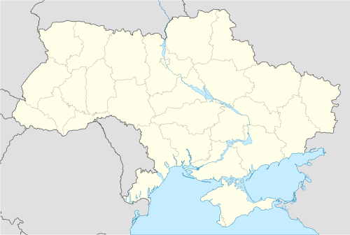
 KievChernihivChernivtsiDnipropetrovskDonetskKharkivLvivOdessaSevastopolUzgorodHoverlaSimferepolIvano-FrankivskSumySvyatogorskChernobylMap of Ukraine
 Relief map
Ukraine is the second-largest country in Europe. Its various regions have diverse geographic features ranging from the highlands to the lowlands.
Contents
Geographic location
Ukraine has a strategic position in East Central Europe, bordering the Black Sea in the south, Poland, Slovakia and Hungary in the west, Belarus in the north, Moldova and Romania in the south-west and Russia in the east.
The northern part of the Carpathian Mountains reach into Ukraine in the western part of the country. The highest peak is Hoverla, which is 2061 m or 6762 ft tall. Most of Ukraine's area is taken up by the steppe-like region just north of the Black Sea. Ukraine is divided almost in half by the Dnipro river, which traverses Ukraine north to south. It empties into the Black Sea, just west of the Crimea and near the mouths of the Bug and the Dnister rivers. The border with Russia is the country's longest border, and it runs through the Sea of Azov.
Geographic coordinates: 49°00′N 32°00′E / 49°N 32°E
Land
 Approximately demonstrates biomes around the Black Sea. Please, note that just south of the Crimean Mountains on the Crimean peninsula there is located area of subtropics as the southern coast of the Black Sea.
The total geographic area of Ukraine is 603,700 square kilometers (233,100 sq mi). The land border of Ukraine totals 4,558 kilometers (2,832 mi). The border lengths with each country are: Belarus 891 kilometers (554 mi), Hungary 103 kilometers (64 mi), Moldova 939 kilometers (583 mi), Poland 428 kilometers (266 mi), Romania 169 kilometers (105 mi) on the south and 362 kilometers (225 mi) on the west, Russia 1,576 kilometers (979 mi), and Slovakia 90 kilometers (56 mi). Ukraine is also bordered by 3,783 kilometers (2,351 mi) of coastline.
Most of Ukraine consists of fertile plains (or steppes) and plateaus. In terms of land use, 58% of Ukraine is considered arable land; 2% is used for permanent crops, 13% for permanent pastures, 18% is forests and woodland, and 9% is other.
Mountains are limited to the west, the southern tip of Ukraine on the Crimean Peninsula, and near the Sea of Azov. The western region has the Carpathian Mountains, the Crimean Peninsula has the Crimean Mountains, and some eroded mountains from the Donets Ridge are in the east near the Sea of Azov. The highest elevation in Ukraine is located at the peak of Mount Hoverla which is 2,061 meters (6,762 ft) above sea level.
Elevation
Most of Ukraine consists of regular plains with the average height above sea level being 175 metres (574 ft). It is surrounded by mountains to its west and extreme south. Wide spaces of the country's plains are located in the south-western part of the East European Plain. The plains have numerous highlands and lowlands caused by the uneven crystallized base of the East European craton. The highlands are characterized by Precambrian basement rocks from the Ukrainian Shield.
Ukraine's various highland regions include the Volyn-Podillia Upland and the Near-Dnipro Upland (on the right bank of Dnipro River) in the west, the south-western spurs of the Central Russian Uplands upon which runs the border with Russia in the east, and the Donets Ridge and the Near Azov Upland near the Sea of Azov. The major lowlands are the Polissian Lowland in the north, the Black Sea Coastal Lowland in the south, and the Dnipro River Lowland that is located on the left bank of Dnipro River towards the north.
Hydrography
Main article: Waterfalls of UkraineThe territory of Ukraine is bordered by the waters of the Black Sea and the Sea of Azov. 90% of the rivers are part of those two seas' drainage basins. A few rivers are part of the Baltic Sea basin. There are seven major rivers in Ukraine: Desna, Dnipro, Dnister, Danube, Prypiat, Siverian Donets, and Southern Buh.
Climate
See also: Climate of UkraineUkraine has a temperate continental climate. The Mediterranean Sea only borders the southern Crimean coast. Ukraine's climates are influenced by the humid air from the Atlantic Ocean.[1] Precipitation in Ukraine is disproportionately distributed, with the most falling in the west and the north, and much less falling in the east and the southeast. June and July are usually the wettest months, while February is usually the driest.[1] Winters vary from cool along the Black Sea to cold farther inland; summers are warm across the greater part of the country, and tend to be very hot in the south.
Natural resources
Significant natural resources in Ukraine include: iron ore, coal, manganese, natural gas, oil, salt, sulfur, graphite, titanium, magnesium, kaolin, nickel, mercury, timber, and arable land.
Environmental issues
Ukraine does have some environmental concerns. Some regions lack adequate supplies of potable water. Air and water pollution affects the country, as well as deforestation, and radiation contamination in the northeast from 1986 accident at Chernobyl Nuclear Power Plant.
See also
- Extreme points of Ukraine
References
- CIA World Factbook, Entry for Ukraine updated May 15 2008.
- ^ a b Ukraine. (2010). In Encyclopædia Britannica. Retrieved August 23, 2010, from Encyclopædia Britannica Online: http://www.britannica.com/EBchecked/topic/612921/Ukraine
Geography of Europe Sovereign
states- Albania
- Andorra
- Armenia
- Austria
- Azerbaijan
- Belarus
- Belgium
- Bosnia and Herzegovina
- Bulgaria
- Croatia
- Cyprus
- Czech Republic
- Denmark
- Estonia
- Finland
- France
- Georgia
- Germany
- Greece
- Hungary
- Iceland
- Ireland
- Italy
- Kazakhstan
- Latvia
- Liechtenstein
- Lithuania
- Luxembourg
- Macedonia
- Malta
- Moldova
- Monaco
- Montenegro
- Netherlands
- Norway
- Poland
- Portugal
- Romania
- Russia
- San Marino
- Serbia
- Slovakia
- Slovenia
- Spain
- Sweden
- Switzerland
- Turkey
- Ukraine
- United Kingdom
- (England
- Northern Ireland
- Scotland
- Wales)
- Vatican City
States with limited
recognitionDependencies
and other territories- Åland
- Faroe Islands
- Gibraltar
- Guernsey
- Jan Mayen
- Jersey
- Isle of Man
- Svalbard
Other entities Climate of Europe Sovereign
states- Albania
- Andorra
- Armenia
- Austria
- Azerbaijan
- Belarus
- Belgium
- Bosnia and Herzegovina
- Bulgaria
- Croatia
- Cyprus
- Czech Republic
- Denmark
- Estonia
- Finland
- France
- Georgia
- Germany
- Greece
- Hungary
- Iceland
- Ireland
- Italy
- Kazakhstan
- Latvia
- Liechtenstein
- Lithuania
- Luxembourg
- Macedonia
- Malta
- Moldova
- Monaco
- Montenegro
- Netherlands
- Norway
- Poland
- Portugal
- Romania
- Russia
- San Marino
- Serbia
- Slovakia
- Slovenia
- Spain
- Sweden
- Switzerland
- Turkey
- Ukraine
- United Kingdom
- (England
- Northern Ireland
- Scotland
- Wales)
- Vatican City
States with limited
recognition- Abkhazia
- Kosovo
- Nagorno-Karabakh
- Northern Cyprus
- South Ossetia
- Transnistria
Dependencies
and other territoriesOther entities - European Union
- Sovereign Military Order of Malta
The Danube Countries 
Cities Tributaries Islands List of crossings Categories:


Wikimedia Foundation. 2010.