- Des Moines, Washington
-
Not to be confused with Des Moines, Iowa.
Des Moines, Washington — City — 
SealLocation of Des Moines, Washington
Coordinates: 47°23′39″N 122°19′5″W / 47.39417°N 122.31806°WCoordinates: 47°23′39″N 122°19′5″W / 47.39417°N 122.31806°W Country United States State Washington County King Area – Total 6.3 sq mi (16.4 km2) – Land 6.3 sq mi (16.4 km2) – Water 0.0 sq mi (0.0 km2) Elevation 92 ft (28 m) Population (2010) – Total 29,673 – Density 4,616.5/sq mi (1,782.5/km2) Time zone Pacific (PST) (UTC-8) – Summer (DST) PDT (UTC-7) ZIP codes 98148, 98198 Area code(s) 206 FIPS code 53-17635[1] GNIS feature ID 1512145[2] Des Moines (
 /dəˈmɔɪnz/ US dict: də·moinz′) is a city in King County, Washington, United States. The population was 29,673 at the 2010 census. Property within the city has been the subject of land buyouts because of noise from aircraft landing or taking off from the Seattle-Tacoma International Airport two miles (about 3.2 km) to the north of Des Moines.[3]
Des Moines is located on the east shore of Puget Sound, approximately halfway between the major cities of Seattle and Tacoma. The city is bordered by the suburbs of Federal Way to the south, Kent to the east, Sea-Tac to the northeast, Burien to the north, and Normandy Park to the northwest. It is one of the few points along this shoreline where the topography facilitates access to the water, and a recreational marina operated by the city, with moorage, boat launching and pier fishing facilities, is located there. Forested Saltwater State Park on a steep ravine between the Zenith and Woodmont neighborhoods is the most-used State Park on the Sound. Near the border of Federal Way, Redondo Beach has a board-walk complete with a Salty's restaurant and a pay parking lot.
Contents
History
There is no evidence that Indian tribes had permanent settlements in Des Moines. However, there is ample evidence that the Duwamish and Muckleshoot Indian tribes came to Des Moines for fishing and clamming.
What was to become Des Moines was first sighted by Europeans on May 26, 1792 during the exploration of British naval Captain George Vancouver on his flagship HMS Discovery. The first Americans to visit the area were part of Charles Wilkes' Expedition.
The first known settler was John Moore who probably arrived about 1867. His homestead claim certificate (#285) was granted on July 2, 1872.
In 1887 F.A. Blasher persuaded some friends in his home city of Des Moines, Iowa, to help finance the development of town on Puget Sound. The work was done by the Des Moines Improvement Company.[4] In 1889 the area was platted into lots and sold by the Des Moines Improvement Company, which had been incorporated by F. A. Blasher, Orin Watts Barlow, Charles M. Johnson, and John W. Kleeb. Lumber mills provided the community with its primary employment.
Early transportation to Des Moines was by water. The Mosquito Fleet provided access to Seattle, Tacoma, and Vashon Island. The first road, the Brick Highway, was completed in May 1916. The first cross-Puget Sound automobile ferry started service from Des Moines to Portage on November 13, 1916. This ferry service continued until September 1921. Before World War II farming fueled the local economy.
Following the war, suburbanization of the community occurred. With increased population, the county government was unable to supply the level of service and local control desired by Des Moines residents. In response to this, Des Moines was officially incorporated on June 17, 1959.
The city's most visible asset is its 838-berth small boat marina that was opened on May 10, 1970. In 1980, a 670 foot concrete and aluminum fishing pier was built at the north end of the marina.[5]
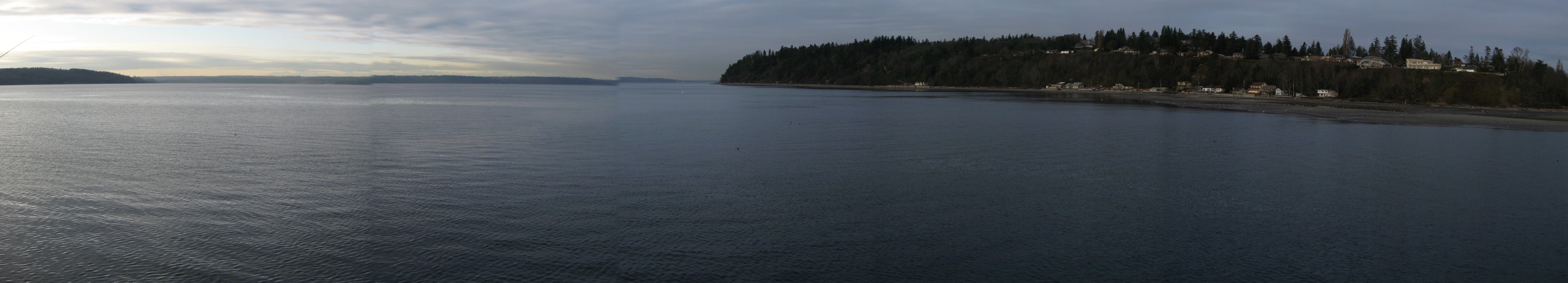
 A view of Puget Sound and the Normandy Park cove from the fishing pier
Geography
Des Moines is located at 47°23′39″N 122°19′5″W / 47.39417°N 122.31806°W (47.394120, -122.317983).[6]
According to the United States Census Bureau, the city has a total area of 6.3 square miles (16.4 km²), all of it land.
Most of the city rolls gently down to the waters of Puget Sound from an elevation of about 400 ft along the eastern city boundary on Pacific Highway, allowing many homes to enjoy an unobstructed view of the sound and Vashon Island. The ravines of Des Moines Creek and Massey Creek deeply incise this broad slope.
Surrounding cities

Burien, SeaTac Puget Sound 
Kent  Des Moines

Federal Way Demographics
Historical populations Census Pop. %± 1890 212 — 1900 162 −23.6% 1940 965 — 1960 1,987 — 1970 4,099 106.3% 1980 7,378 80.0% 1990 17,283 134.3% 2000 29,267 69.3% 2010 29,673 1.4%  The Des Moines Field House / Activity Center, a legacy of the WPA, is listed as a King County landmark.
As of the census[1] of 2000, there were 29,267 people, 11,337 households, and 7,289 families residing in the city. The population density was 4,616.5 people per square mile (1,782.3/km²). There were 11,777 housing units at an average density of 1,857.7 per square mile (717.2/km²). The racial makeup of the city was 74.15% White, 7.20% African American, 0.96% Native American, 8.28% Asian, 1.34% Pacific Islander, 3.32% from other races, and 4.76% from two or more races. Hispanic or Latino of any race were 6.61% of the population.
There were 11,337 households out of which 30.4% had children under the age of 18 living with them, 47.1% were married couples living together, 12.2% had a female householder with no husband present, and 35.7% were non-families. 27.8% of all households were made up of individuals and 6.9% had someone living alone who was 65 years of age or older. The average household size was 2.47 and the average family size was 3.02.
In the city the population was spread out with 23.8% under the age of 18, 8.3% from 18 to 24, 31.1% from 25 to 44, 22.0% from 45 to 64, and 14.9% who were 65 years of age or older. The median age was 37 years. For every 100 females there were 93.0 males. For every 100 females age 18 and over, there were 89.4 males.
The median income for a household in the city was $48,971, and the median income for a family was $57,003. Males had a median income of $40,007 versus $30,553 for females. The per capita income for the city was $24,127. About 5.6% of families and 7.6% of the population were below the poverty line, including 9.6% of those under age 18 and 2.8% of those age 65 or over.
Education
Primary and secondary schools
Most of Des Moines is within the Highline Public Schools district; the neighborhoods of Woodmont and Redondo are within the Federal Way School District.
Elementary schools within Des Moines include Des Moines Elementary School, Midway Elementary School, North Hill Elementary School, Olympic Hill Elementary School, Parkside Elementary School, and Woodmont Elementary School (Woodmont is a part of the Federal Way School District).[7][8]
Pacific Middle School, Aviation High School, and Mount Rainier High School are the secondary schools of Des Moines.[8]
Community colleges
Highline Community College is in Des Moines.[8]
Parks and recreation
Saltwater State Park is in Des Moines.[8]
City landmarks
The City of Des Moines has designated the following landmark:
Landmark Built Listed Address Photo Des Moines Beach Park[9] (the former Covenant Beach Bible Camp) 1917–1931 2005 Cliff Ave. and 220th St.
47°24′26″N 122°19′43″W / 47.40722°N 122.32861°W
References
- ^ a b "American FactFinder". United States Census Bureau. http://factfinder.census.gov. Retrieved 2008-01-31.
- ^ "US Board on Geographic Names". United States Geological Survey. 2007-10-25. http://geonames.usgs.gov. Retrieved 2008-01-31.
- ^ Des Moines Historical Society Time Line 1970's
- ^ "Des Moines". Washington Place Names database. Tacoma Public Library. http://search.tpl.lib.wa.us/wanames/. Retrieved 2009-03-06.
- ^ One Hundred Years of the "Waterland" Community: A History of Des Moines, Washington, 1989
- ^ "US Gazetteer files: 2010, 2000, and 1990". United States Census Bureau. 2011-02-12. http://www.census.gov/geo/www/gazetteer/gazette.html. Retrieved 2011-04-23.
- ^ "Federal Way Public School District" Retrieved on May 31, 2010.
- ^ a b c d "Detailed Street Map." City of Des Moines. Retrieved on February 28, 2010.
- ^ Recent Landmarks Designations, King County Landmarks Commission. Accessed 2009-05-09.
External links
 State of Washington
Topics State government | Cities | Towns | Congressional delegation | City governments | Governors | History | Geography | People | Legislative initiatives | Popular initiatives | Legislature | Music | Parks | Highways | Symbols | Visitor attractions
Society Demographics · Economy · Education · Politics
Regions Larger cities and
metropolitan areasSeattle | Seattle metropolitan area | Spokane | Tacoma | Tri-Cities | Vancouver | Bellevue | Everett | Yakima
Smaller cities Aberdeen | Anacortes | Arlington | Auburn | Bainbridge Island | Battle Ground | Bellingham | Bonney Lake | Bothell | Bremerton | Burien | Camas | Centralia | Cheney | Cle Elum | Coupeville | Covington | Des Moines | East Wenatchee | Edmonds | Ellensburg | Enumclaw | Federal Way | Fort Lewis | Grandview | Hoquiam | Issaquah | Kelso | Kenmore | Kennewick | Kent | Kirkland | Lacey | Lake Forest Park | Lake Stevens | Lakewood | Langley | Longview | Lynden | Lynnwood | Mabton | Maple Valley | Marysville | Mercer Island | Mill Creek | Monroe | Moses Lake | Mountlake Terrace | Mount Vernon | Mukilteo | Naches | Oak Harbor | Olympia | Pasco | Port Angeles | Port Orchard | Port Townsend | Prosser | Pullman | Puyallup | Redmond | Renton | Richland | Sammamish | SeaTac | Sedro-Woolley | Selah | Shelton | Shoreline | Silverdale | Spokane Valley | Sunnyside | Toppenish | Tukwila | Tumwater | University Place | Walla Walla | Wapato | Washougal | Wenatchee | West Richland | Woodinville | Zillah
Counties Adams | Asotin | Benton | Chelan | Clallam | Clark | Columbia | Cowlitz | Douglas | Ferry | Franklin | Garfield | Grant | Grays Harbor | Island | Jefferson | King | Kitsap | Kittitas | Klickitat | Lewis | Lincoln | Mason | Okanogan | Pacific | Pend Oreille | Pierce | San Juan | Skagit | Skamania | Snohomish | Spokane | Stevens | Thurston | Wahkiakum | Walla Walla | Whatcom | Whitman | Yakima
Steamboats of Puget Sound and western Washington State Propellers Wood- Albion
- Alice (1897)
- Alice Gertrude
- Annie M. Pence
- Aquilo
- Atlanta
- Audrey
- Bay Island
- Bellingham
- Burton
- C.C. Calkins
- C.C. Cherry
- Calista
- Camano
- Clallam
- Concordia
- Crest
- Crystal
- Daring
- Dart
- Dauntless
- Defiance
- Dix
- Dode
- Dove
- Eagle
- Elfin
- Elk
- Elsinore
- Fleetwood
- Florence K
- Fortuna
- Flyer
- General Miles
- Hattie Hansen
- Hector
- Hyak
- Inland Flyer
- Iola
- Island Princess
- Islander
- Katherine
- L.T. Haas
- Lady of the Lake
- Magnolia
- Mizpah
- Monticello 2
- Otter
- Quickstep
- Rosalie
- Sentinel
- Triton
- Urania
- Vashon
- Verona
- Victor
- Virginia V
- Willapa
SteelSternwheelers Sidewheelers Steam tugs Steam ferries ConvertedPurpose-builtMotor vessels TowingPacific Tow Boat Co.Ferry- Kitsap County Trans. Co.
- Oreg. & Wash. Ferry & Nav. Go.
- Puget Sound Nav. Co.
- West Seattle Land & Improv. Co.
Shipyards - Crawford & Reid
- J.F. Duthie
- Holland
- King & Winge
- Lake Washington
- Moran Bros.
- Martinolich
Personnel - William Ballard
- Thomas Coupe
- Joshua Green
- Matthew McDowell
OregonBritish Columbia- Upper Fraser River
- Lakes Route
- Arrow Lakes
- Okanagan Lake
- Upper Columbia and Kootenay Rivers
- Skeena River
- Stikine River
- Peace River
Alaska and YukonOtherNavboxes - Columbia River
- British Columbia
- California
Lists of vessels related topic: Washington State FerriesCategories:- Cities in King County, Washington
- Populated places established in 1889
- Populated places on Puget Sound


Wikimedia Foundation. 2010.