- Ontario Highway 71
-
Highway 71

Route information Length: 194 km[2] (121 mi) Existed: September 1, 1937[1] – present Major junctions South end:  US 71 at International Falls, MN
 Highway 11
35.9 km (22.3 mi) concurrencyNorth end:  Highway 17 near Kenora
Location Major cities: Fort Frances, Emo, Sioux Narrows, Kenora Highway system Ontario provincial highways
400-series • Former←  Highway 69
Highway 72  →
→King's Highway 71, commonly referred to as Highway 71, is a provincially maintained highway in the Canadian province of Ontario. The 194-kilometre (121 mi) route travels concurrently with Highway 11 for 40 kilometres (25 mi) from the Fort Frances-International Falls International Bridge in Fort Frances, where it continues south as U.S. Route 71, to Chapple. From there, Highway 71 travels north for 154 kilometres (96 mi) to a junction with Highway 17 just east of Kenora. Highway 71 is part of the Trans-Canada Highway for its entire length.
Contents
Route description
Highway 71 is a 194.1-kilometre (120.6 mi) route which connects the Rainy River region with the Trans Canada Highway near Kenora. The first 65 kilometres (40 mi) of the highway traverse the largest pocket of arable land in northern Ontario. Following that, the route suddenly enters the Canadian Shield, where the land is unsuitable for agricultural development.[3]
The highway begins at the international bridge in Fort Frances, where it proceeds north along Central Avenue, encountering Highway 11 one block north. The two routes travel concurrently north to 3 Street West, where both turn west. At the Fort Frances Cemetery, the route branches southwest and exits Fort Frances after splitting with the Colonization Road (Highway 602). It follows the old Cloverleaf Trail west through Devlin, where it intersects Highway 613, and Emo, where it merges with the Colonization Road. Approximately 6 kilometres (3.7 mi) west of Emo, in the Manitou Rapids First Nations Reserve, Highway 71 branches north, while Highway 11 continues west to Rainy River.[4]
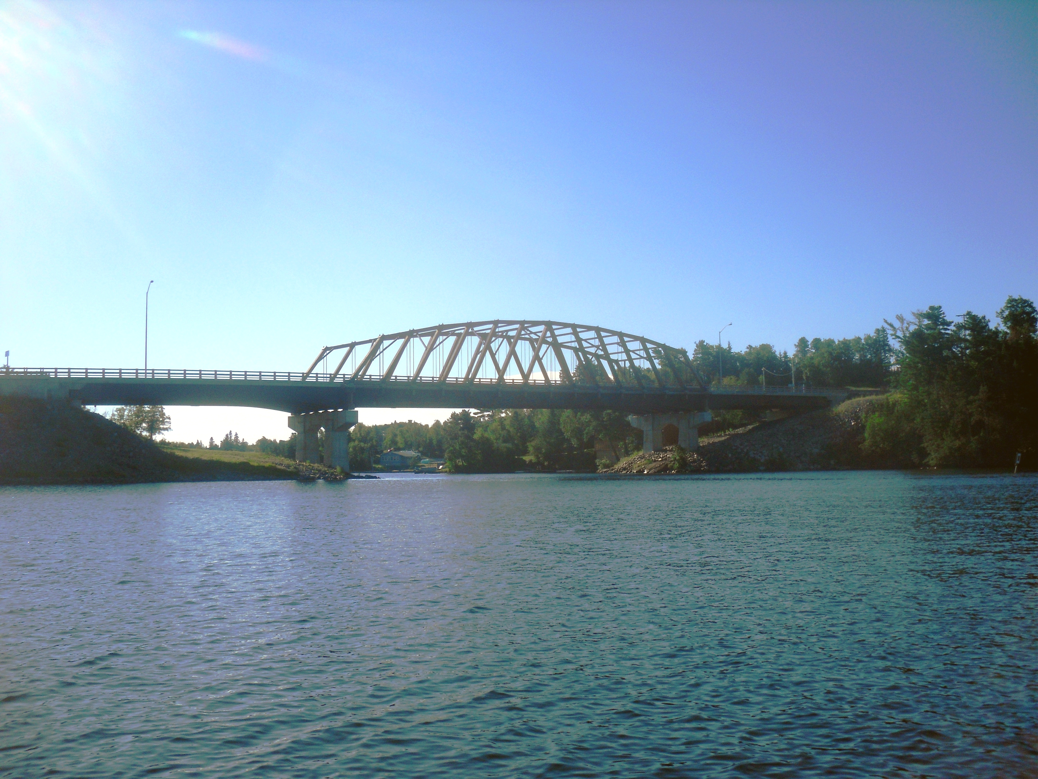
 The New Sioux Narrows Bridge
North of the Manitou Rapids Reserve, Highway 71 presses through a large swath of land mostly occupied by horse and cattle ranches. It intersects Highway 600 and Highway 615, both of which have historical connections to Highway 71.[4] The highway passes through Finland and enters the Boreal Forest, descending into the Canadian Shield over the course of a kilometre and a half.[5] From this point to its northern terminus, the highway crosses through rugged and isolated terrain, curving around lakes, rivers and mountains on its northward journey. It passes through the community of Caliper Lake before crossing between Rainy River District and Kenora District midway between there and Nestor Falls. North of Nestor Falls, the highway travels along the eastern shore of Lake of the Woods, providing access to Crow Lake, as well as to Whitefish Bay just southeast of Sioux Narrows.[4] Here the route crosses the Sioux Narrows Bridge, the last part of the highway to be constructed and a formidable engineering obstacle in the 1930s.[6] North of Sioux Narrows, the highway meanders northward through an uninhabited region, zig-zaging among the numerous lakes that dot Kenora District. It provides access to Eagle Dogtooth and Rushing River Provincial Parks several kilometres south of its northern terminus at Highway 17, 4 kilometres (2.5 mi) east of the split with the Highway 17A and 20 kilometres (12 mi) east of downtown Kenora.[4]
History
The modern Highway 71 was created out of a renumbering of several highways in the Rainy River District during the late 1950s as Highway 11 was extended west of Thunder Bay. The history of the route is tied to the two major highways in Rainy River District: the Cloverleaf Trail and the Heenan Highway.
 Highway 71 overlooking Lake of the Woods
The Cloverleaf Trail, the older of the two roads, was initially developed as the Rainy River colonization road. A trail was blazed as early as 1875, possibly as part of the Dawson Trail, and improved by 1885 into a wagon trail. This initial trail followed the Rainy River west from Fort Frances to Lake of the Woods; Highway 602 follows the road between Fort Frances and Emo. In 1911, James Arthur Mathieu was elected as a MPP in the Rainy River riding. As a lumber merchant, Mathieu promoted improved road access in the region. Between 1911 and 1915, he oversaw construction of the gravel Cloverleaf Trail between Fort Frances and Rainy River.[7]</ref>
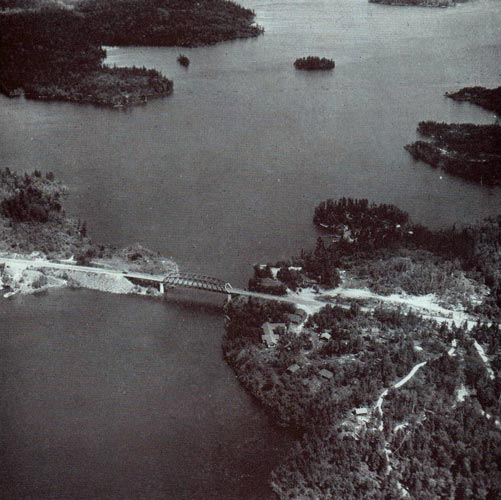
The Heenan Highway would become the first Canadian link to the Rainy River area; prior to its opening in the mid-1930s, the only way to drive to the area was via the United States. In 1922, Kenora MPP Peter Heenan and Dr. McTaggart approached the government to lobby for construction of a road between Nestor Falls and Kenora. Nestor Falls was the northernmost point accessible by road from the Rainy River area. Heenan would become the Minister of Lands and Forests in Mitch Hepburn's cabinet.[8] This provided the impetus for construction to begin in 1934.[9] Unlike the Cloverleaf Trail, the Fort Frances – Kenora Highway, as it was known prior to its opening, was constructed through the rugged terrain of the Canadian Shield. Rocks, forests, lakes, muskeg, and insects served as major obstacles during construction of the 100-kilometre (62 mi) highway, which progressed from both ends. By late 1935, the only remaining gap in the road was the Sioux Narrows Bridge. Construction on this bridge was underway by March 1936; it was rapidly assembled using Douglas fir from British Columbia as the main structural members. The bridge was completed on June 15, 1936, completing the link between Fort Frances and Kenora.[6]
 Sioux Narrows Bridge in 1951
On July 1, 1936, premier Mitch Hepburn attended a ceremony in front of the Rainy Lake Hotel in Fort Frances.[6] On a rainy afternoon, at 5:30 p.m., Peter Heenan handed Hepburn a pair of scissors with which to cut the ribbon crossing the road and declare the highway open. Hepburn, addressing the crowd that was gathered, asked "What would you say if we call it the Heenan Highway, what would you think of that?". The crowd cheered and Hepburn cut the ribbon.[8]
The Cloverleaf Trail and the Heenan Highway were assumed by the Department of Highways (DHO) shortly after its merger with the Department of Northern Development. Following the merger, the DHO begin assigning trunk roads throughout northern Ontario as part of the provincial highway network.[10][11] Highway 71 was assigned on September 1, 1937 along the Cloverleaf Trail. The portion of the Heenan Highway lying within Kenora District was designated as Highway 70 on September 1 as well. The portion within Rainy River District was designated as Highway 70 on September 29.[1]
The original route of Highway 70 split in two south of Finland; Highway 70 turned east to Off Lake Corner, then south to Emo, while Highway 70A turned west to Black Hawk then south to Barwick. The northern end of the highway was also concurrent with Highway 17 for 21.7 kilometres (13.5 mi) into Kenora, and the southern end concurrent with Highway 71 for 37.0 kilometres (23.0 mi) between Emo and Fort Frances.[12] During 1952, the highway was extended south from its split to Highway 71, midway between Barwick and Emo. By 1953, the new road was opened and informally designated as the new route of Highway 70. The old routes were decommissioned on February 8, and the new route designated on March 10, 1954.[13]
Throughout the mid to late 1950s, a new highway was constructed west from Thunder Bay towards Fort Frances. Initially this road was designated as Highway 120. In 1959, it was instead decided to make this new link a westward extension of Highway 11; a major renumbering took place: Highway 11 was established between Rainy River and Fort Frances, Highway 71 was truncated west of the Highway 70 junction, and the entirety of Highway 70 was renumbered as Highway 71.[14][15] This established the current routing of the highway.[4]
Although now rebuilt as a steel structure, the original Sioux Narrows Bridge was considered to be the longest single span wooden bridge in North America, at 64 metres (210 ft).[6]
Major intersections
The following table lists the major junctions along Highway 71. In addition, it includes some minor junctions that are noted by the Ministry of Transportation of Ontario.[2]
Division[4] Location km[2] Destinations Notes Fort Frances-International Falls International Bridge over the Rainy River
 Highway 71 continues into Minnesota as U.S. 53 / U.S. 71
Rainy River Fort Frances 0.0 0.1 Highway 11 east (Colonization Road) – Thunder BayBeginning of Highway 11 concurrency 2.2 Highway 602 (Colonization Road) – Emo Devlin 21.3 Highway 613 – Northwest Bay Emo 34.0 Highway 602 (Colonization Road) – Fort Frances Chapple 40.2 Highway 11 west – Rainy RiverEnd of Highway 11 concurrency 58.6  Highway 600 west – Black Hawk
Highway 615 east – Off Lake CornerKenora Sioux Narrows 139.3 Sioux Narrows Bridge Unorganized Kenora District 174.0 Andy Lake Road 194.1 Highway 17 – Kenora, Dryden1.000 mi = 1.609 km; 1.000 km = 0.621 mi References
- ^ a b Annual Report (Report). Department of Highways. March 31, 1938. p. 80.
- ^ a b c Ministry of Transportation of Ontario (2008). "Annual Average Daily Traffic (AADT) counts". http://www.raqsb.mto.gov.on.ca/techpubs/TrafficVolumes.nsf/tvweb?OpenForm&Seq=5. Retrieved November 19, 2011.
- ^ (PDF) Rainy River District Agricultural Economic Impact Study (Report). Harry Cummings and Associates. October 2009. p. 17. http://www.hcaconsulting.ca/pdfs/2009%20Rainy%20River%20District%20Agri%20Economic%20Impact.pdf. Retrieved November 19, 2011.
- ^ a b c d e f Peter Heiler (2010). Ontario Back Road Atlas (Map). Cartography by MapArt. p. 106, section G3–H4. ISBN 978-1-55198-226-7.
- ^ Google, Inc. Google Maps – Highway 71 north of Finland, Ontario (Map). Cartography by Google, Inc. http://g.co/maps/a4zu. Retrieved September 5, 2011.
- ^ a b c d "Sioux Narrows Bridge". Sioux Narrows Nestor Falls. http://www.siouxnarrows-nestorfalls.ca/municipal-government/community-profile/history/sioux-narrows-bridge. Retrieved November 19, 2011.
- ^ "Between the Ripples...Stories of Chapple". Fort Frances Times. 1997. http://www.fftimes.com/100-years-100-stories/chappletransportation.html. Retrieved November 19, 2011.
- ^ a b "Highway Officially Opened By Premier M.F. Hepburn Named "Heenan Highway"". Fort Frances Times and Rainy Lake Herald. July 2, 1936. http://www.fftimes.com/100-years-100-stories/highwayopened.html. Retrieved November 19, 2011.
- ^ Sessional Papers (Report). 70. Province of Ontario. 1939. http://books.google.ca/books?id=kT8lAQAAIAAJ&q=%22Heenan+Highway%22&dq=%22Heenan+Highway%22&hl=en&ei=w2RkTt77O8_F0AHV2c39CQ&sa=X&oi=book_result&ct=result&resnum=6&ved=0CD0Q6AEwBQ. Retrieved November 19, 2011. "In Kenora the contract for construction of 48 miles of grading and gravelling on the Heenan Highway, started in 1934, was officially completed and this Highway, linking Fort Frances and Rainy River to Kenora was officially opened in June."
- ^ Shragge, John; Bagnato, Sharon (1984). From Footpaths to Freeways. Ontario Ministry of Transportation and Communications, Historical Committee. p. 71. ISBN 0-7743-9388-2.
- ^ Smith, R. M (March 31, 1938). Annual Report (Report). Department of Highways. p. 8.
- ^ Ontario Department of Highways (1956). Ontario Road Map (Map). Cartography by C.P. Robins. Section F4–H6, Northern portion inset.
- ^ Annual Report (Report). Department of Highways. March 31, 1954. p. 154, 156.
- ^ Ontario Department of Highways (1959). Ontario Road Map (Map). Cartography by C.P. Robins. Section F4–H6, Northern portion inset.
- ^ Ontario Department of Highways (1960). Ontario Road Map (Map). Cartography by C.P. Robins. Section F4–H6, Northern portion inset.
The King's Highways of Ontario Current highwaysFormer highways- 2A
- 2B
- 2S
- 3B
- 4A
- 5A
- 7B
- 8A
- 12B
- 14
- 15A
- 18
- 18A
- 22
- 24A
- 25
- 27
- 29
- 30
- 31
- 32
- 35A
- 35B
- 36
- 38
- 39
- 40B
- 42
- 43
- 44
- 45
- 46
- 47
- 48B
- 50
- 51
- 52
- 53
- 54
- 55
- 56
- 57
- 59
- 68
- 70
- 73
- 74
- 75
- 76
- 78
- 79
- 80
- 81
- 82
- 83
- 84
- 86
- 87
- 88
- 90
- 91
- 92
- 95
- 96
- 97
- 98
- 99
- 100
- 103
- 104
- 106
- 107
- 109
- 110
- 111
- 114
- 116
- 117
- 119
- 120
- 121
- 122
- 123
- 126
- 128
- 131
- 133
- 134
- 135
- 136
- 169
- 400A
- 401A
County roads in Ontario · Ontario numbered highways · Expressways and 400-series highways · King's Highways · Secondary highways · Tertiary and 7000-series highways · List of Ontario provincial highways · List of former provincial highways in Ontario · Highways in Ontario · List of Ontario expressways · Trans-Canada Highway · Connecting Link · Emergency Detour RouteCategories:- Ontario provincial highways
- Trans-Canada Highway
- Roads in Rainy River District, Ontario
- Roads in Kenora District, Ontario


Wikimedia Foundation. 2010.