- Ontario Highway 27
-
Highway 27
York Regional Road 27
Simcoe County Road 27Route information Maintained by the Regional Municipality of York and the County of Simcoe Existed: September 14, 1927[1] – January 1, 1998[2] Major junctions South end:  Highway 401 – Toronto
 Highway 7 – Woodbridge, Vaughan
 Highway 9 – Schomberg
 Highway 89 – Cookstown
 Highway 400 – Barrie
 Highway 26 – Midhurst
North end:  Highway 93
Highway system Ontario provincial highways
400-series • Former←  Highway 26
Highway 28  →
→Highway 27, formerly known as King's Highway 27, was a provincially maintained highway in southern Ontario that is now cared for by the city of Toronto, York Region and Simcoe County. It is considered an undivided expressway in Toronto's municipal expressway network. The Ministry of Transportation of Ontario was once responsible for the length of this route, when it ran through much of Southern Ontario.
Contents
Route description
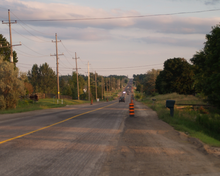 Highway 27 south of Schomberg
Highway 27 followed a mostly straight route throughout its length. Between Toronto and the York–Simcoe boundary at Highway 9, it travelled along the 7th concession road west of Yonge Street. North of there it is generally parallel to the Penetanguishene Road and Highway 400. North of Kleinburg, the vast majority of the highway was surrounded by rural farmland. South of there, it travelled through the suburbs of Toronto.
The highway began at off-ramps from the collectors lanes of Highway 427, which was redesignated from Highway 27 in 1972, as a four-lane divided expressway. Through Etobicoke, it encountered mostly industrial surroundings. North of the Metro boundary at Steeles Avenue, the highway came under provincial responsibility. Within the Regional Municipality of York, Highway 27 passed along the western edge of suburban sprawl in Vaughan, near the community of Woodbridge. At Kleinburg, the highway dipped into the Humber River valley, connecting with Islington Avenue. North of the valley, it continued through King Township, dividing the village of Nobleton and entering Schomberg immediately south of Highway 9, after which the highway entered Simcoe County.
North of Highway 9, the route curved 1.5 km (0.93 mi) to the east, then continued north, parallel to Highway 400. It travelled through the village of Bond Head and thereafter met Highway 89 in Cookstown. As the highway approached Barrie, it curved and followed Essa Road northeast until it met Highway 400. Through Barrie, it was concurrent with Highway 400 between Exit 94 and Exit 98, after which it was concurrent with Highway 26 along Bayfield Street, travelling north and exiting the city. At Midhurst, Highway 27 diverged from its concurrency to continue north, parallel to and 4 km (2.5 mi) west of Highway 400. After passing through the village of Elmvale, the highway abruptly curves to the east, ending at Highway 93 south of Midland and Penetanguishene.
History
Highway 27 was first designated between Barrie and Penetanguishine on September 14 1927.[1] On March 28, 1934 it was extended south to Schomberg via county roads south of Barrie.[3] On August 12, 1936, Browns Line and Eaton Road were designated as part of Highway 27, creating an isolated section of the route between Long Branch and Elder Mills (at the modern intersection of Rutherford Road). On the same date, the road between Schomberg and Kleinburg was designated as part of Highway 27, leaving a gap between Elder Mills and Kleinburg, through the Humber valley. This gap was closed beginning in late 1936. It was completed and opened to traffic in 1938, bringing Highway 27 to its peak length of 148 km (92 mi). In the mid-1950s, the Toronto Bypass was constructed between Highway 2A and the Queen Elizabeth Way, widening Highway 27 to a four lane freeway in the process. This section was reconstructed again throughout the 1960s into a twelve-lane collector-express system. In mid-1972, the section of Highway 27 south of Eglinton Avenue was re-designated as Browns Line and Highway 427. The section from Eglinton Avenue north to Penetanguishine was decommissioned on January 1, 1998.[2] It is still known as Highway 27 within Toronto, but is locally maintained. North of Toronto, it is known as Regional / County Road 27, depending on the jurisdiction.
Major intersections
The following table lists the major junctions along Highway 27.
Division Location[4] km[5] Destinations Notes Toronto 0.0  Highway 427 south
0.6 Eglinton Avenue Grade-separated interchange 2.9 Dixon Road Grade-separated interchange 6.1 Rexdale Boulevard 9.3 Albion Road Formerly Highway 50 10.6 Steeles Avenue York Region Vaughan 12.7 Highway 7Highway 7 was decommissioned through York Region on the same day as Highway 27 Kleinburg 20.7  Regional Road 49 (Nashville Road)
Formerly Highway 49 21.2 Islington Avenue Nobleton 27.5  Regional Road 11 (King Road)
King 33.8 Sideroad 17 Formerly York Regional Road 15 37.8  Regional Road 16 (Lloydtown Road) – Lloydtown, Pottageville
Schomberg 38.5  Regional Road 76 (Main Street)
39.9 Highway 9 – Orangeville, NewmarketSimcoe County Bradford West Gwillimbury 49.4 County Road 88 – Bradford Formerly Highway 88 50.8 County Road 1 (8th Line) – Beeton Innisfil 60.9 Highway 89 (Queen Street) – Alliston, ShelburneThornton 69.7 County Road 20 west (Robert Street) 70.2 County Road 20 east (Innisfil Beach Road) Innisfil 73.1 County Road 27 Formerly Highway 131 and once the route of Highway 27 Barrie 80.0 Highway 400Exit 94 80.9 Burton Avenue Formerly Highway 11 82.9 Dunlop Street West Formerly Highway 90 83.2 Dunlop Street East Formerly Highway 11 and Highway 26 84.5 Highway 400Exit 98; Current eastern terminus of Highway 26[4] Simcoe County Midhurst 89.6 County Road 43 (Snow Valley Road) 90.4 Highway 26 – Collingwood, Owen SoundSpringwater 98.1 County Road 22 (Horseshoe Valley Road) – Horseshoe Valley Elmvale 109.2 County Road 92 (Queen Street) – Wasaga Beach Formerly Highway 92 Saurin 111.0 County Road 6 Tay 119.4 Highway 93 (Penetanguishene Road) – Midland, PenetanguisheneSee also
References
- ^ a b Annual Report (Report). Department of Highways. March 31, 1928. p. 60.
- ^ a b Highway Transfers List - “Who Does What” (Report). Ministry of Transportation of Ontario. June 20, 2001. pp. 4, 13–14.
- ^ Annual Report (Report). Department of Highways. March 31, 1935. p. 120.
- ^ a b Peter Heiler (2010). Ontario Back Road Atlas (Map). Cartography by MapArt. p. 24, 30, 41, section Z28–K31. ISBN 978-1-55198-226-7.
- ^ Ministry of Transportation of Ontario (April 1, 1989). Provincial Highways Distance Table. Government of Ontario. p. 53. ISSN 0825-5350.
Major roads in Toronto North-south Bathurst · Bayview · Birchmount · Brimley · Browns Line · Dufferin · Islington · Jane · Keele · Kennedy · Kipling · Leslie · Markham · Martin Grove · McCowan · Morningside · Royal York · Victoria Park · Warden · Weston · Woodbine · YongeOther streetsAvenue/University · Bay · Black Creek · De Grassi · Jameson · Jarvis · John · Lansdowne · Mount Pleasant · Ossington · Palmerston · Parliament · Roncesvalles · Spadina · VaughanEast-west Concession roadsBloor/Danforth · Eglinton · Finch · Lawrence · Sheppard · St. Clair · Steeles · The Queensway/Queen West/Queen East · York MillsOther streetsCollege/Carlton · Dundas · Eastern · Front · Gerrard · King · Kingston · Lake Shore · Queen's Quay · RaymoreExpressways and highwaysThe King's Highways of Ontario Current highwaysFormer highways- 2A
- 2B
- 2S
- 3B
- 4A
- 5A
- 7B
- 8A
- 12B
- 14
- 15A
- 18
- 18A
- 22
- 24A
- 25
- 27
- 29
- 30
- 31
- 32
- 35A
- 35B
- 36
- 38
- 39
- 40B
- 42
- 43
- 44
- 45
- 46
- 47
- 48B
- 50
- 51
- 52
- 53
- 54
- 55
- 56
- 57
- 59
- 68
- 70
- 73
- 74
- 75
- 76
- 78
- 79
- 80
- 81
- 82
- 83
- 84
- 86
- 87
- 88
- 90
- 91
- 92
- 95
- 96
- 97
- 98
- 99
- 100
- 103
- 104
- 106
- 107
- 109
- 110
- 111
- 114
- 116
- 117
- 119
- 120
- 121
- 122
- 123
- 126
- 128
- 131
- 133
- 134
- 135
- 136
- 169
- 400A
- 401A
County roads in Ontario · Ontario numbered highways · Expressways and 400-series highways · King's Highways · Secondary highways · Tertiary and 7000-series highways · List of Ontario provincial highways · List of former provincial highways in Ontario · Highways in Ontario · List of Ontario expressways · Trans-Canada Highway · Connecting Link · Emergency Detour RouteCategories:- Toronto highways
- Ontario provincial highways


Wikimedia Foundation. 2010.