- National Register of Historic Places listings in Schenectady County, New York
-
 Location of Schenectady County in New York
List of the National Register of Historic Places listings in Schenectady County, New York
This is intended to be a complete list of properties and districts listed on the National Register of Historic Places in Schenectady County, New York. The locations of National Register properties and districts (at least for all showing latitude and longitude coordinates below) may be seen in a Google map by clicking on "Map of all coordinates".[1] Three of the sites are further designated U.S. National Historic Landmarks.
-
- This National Park Service list is complete through NPS recent listings posted November 18, 2011.[2]
Contents: Counties in New York Albany (Albany) – Allegany – Bronx – Broome – Cattaraugus – Cayuga – Chautauqua – Chemung – Chenango – Clinton – Columbia – Cortland – Delaware – Dutchess – Erie (Buffalo) – Essex – Franklin – Fulton – Genesee – Greene – Hamilton – Herkimer – Jefferson – Kings (Brooklyn) – Lewis – Livingston – Madison – Monroe (Rochester) – Montgomery – Nassau – New York (Manhattan – Below 14th Street, 14th to 59th Streets, 59th to 110th Streets, Above 110th Street, Islands) – Niagara – Oneida – Onondaga (Syracuse) – Ontario – Orange – Orleans – Oswego – Otsego – Putnam – Queens – Rensselaer – Richmond (Staten Island) – Rockland – Saratoga – Schenectady – Schoharie – Schuyler – Seneca – St. Lawrence – Steuben – Suffolk – Sullivan – Tioga – Tompkins – Ulster – Warren – Washington – Wayne – Westchester (New Rochelle, Peekskill, Yonkers) – Wyoming – Yates Listings county-wide
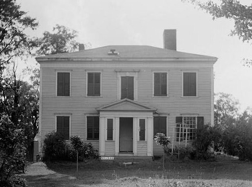
[3] Landmark name Image Date listed Location City or town Summary 1 Abrahams Farmhouse October 11, 1984 Hardin Rd.
42°48′30″N 74°11′25″W / 42.808333°N 74.190278°WDuanesburg 2 Avery Farmhouse October 11, 1984 NY 30
42°46′11″N 74°14′00″W / 42.769722°N 74.233333°WDuanesburg 3 H. S. Barney Building July 19, 1984 217-229 State St.
42°48′55″N 73°56′44″W / 42.815278°N 73.945556°WSchenectady 4 Becker Farmhouse October 11, 1984 Creek Rd.
42°45′07″N 74°15′43″W / 42.751944°N 74.261944°WDuanesburg 5 Bishop Family Lustron House March 6, 2008 26 Slater Dr.
42°53′20″N 73°54′52″W / 42.888889°N 73.914444°WGlenville 6 Joseph Braman House April 24, 1987 Braman's Corners
42°48′31″N 74°13′10″W / 42.808611°N 74.219444°WDuanesburg 7 Brandywine Avenue School December 9, 1999 108 Brandywine Ave.
42°48′08″N 73°55′29″W / 42.802222°N 73.924722°WSchenectady 8 Central Fire Station April 11, 1985 Erie Blvd.
42°48′48″N 73°56′47″W / 42.813333°N 73.946389°WSchenectady 9 Chadwick Farmhouse October 11, 1984 Schoharie Tpk.
42°44′17″N 74°10′16″W / 42.738056°N 74.171111°WDuanesburg 10 Chapman Farmhouse October 11, 1984 Miller's Corners Rd.
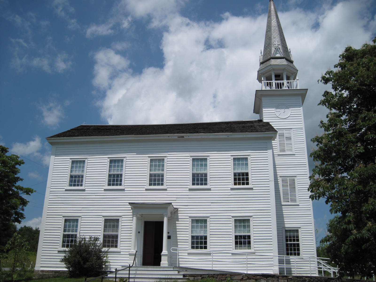
42°48′44″N 74°13′16″W / 42.812222°N 74.221111°WDuanesburg 11 Christ Episcopal Church 
April 24, 1987 NY 20
42°46′07″N 74°09′17″W / 42.768611°N 74.154722°WDuanesburg 12 Christman Bird and Wildlife Sanctuary 
August 25, 1970 Schoharie Tpke.
42°44′27″N 74°07′30″W / 42.740833°N 74.125°WDelanson 13 Delanson Historic District 
October 11, 1984 Main St.
42°44′35″N 74°11′16″W / 42.743056°N 74.187778°WDelanson 14 Dellemont-Wemple Farm October 25, 1973 W of Schenectady on Wemple Rd.
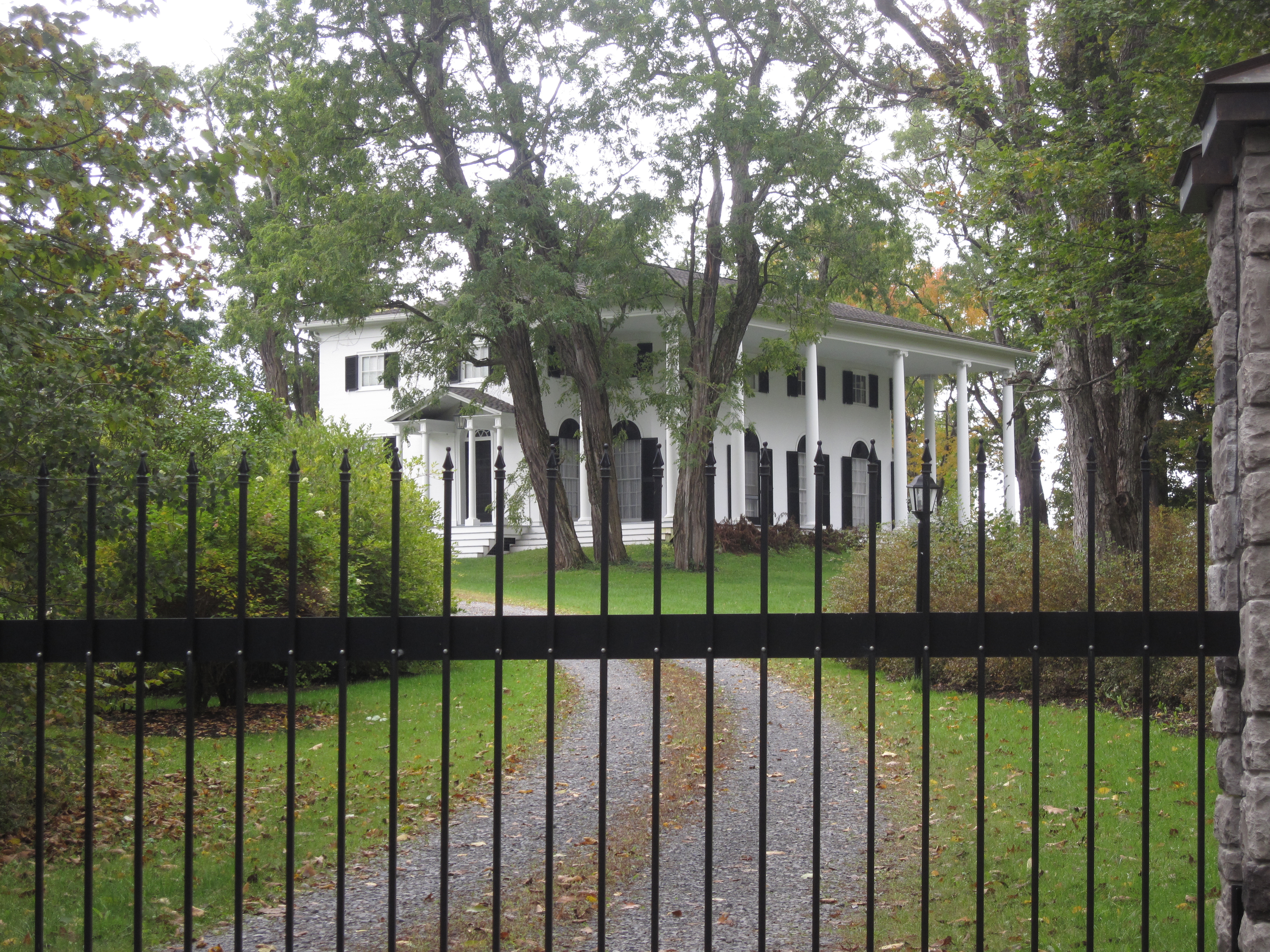
42°46′16″N 74°00′30″W / 42.771111°N 74.008333°WRotterdam 15 Duane Mansion 
April 24, 1987 NY 20
42°45′16″N 74°07′41″W / 42.754444°N 74.128056°WDuanesburg 16 Duanesburg-Florida Baptist Church October 11, 1984 NY 30
42°48′31″N 74°12′58″W / 42.808611°N 74.216111°WDuanesburg 17 Eatons Corners Historic District October 11, 1984 Eatons Corners Rd.
42°48′21″N 74°14′50″W / 42.805833°N 74.247222°WDuanesburg 18 Enlarged Double Lock No. 23, Old Erie Canal 
March 6, 2008 Rice Rd.
42°49′25″N 73°59′13″W / 42.823611°N 73.986944°WRotterdam 19 Ferguson Farm Complex April 24, 1987 NY 20
42°45′37″N 74°06′56″W / 42.760278°N 74.115556°WDuanesburg 20 Foster Building 
June 3, 1991 508 State St.
42°48′42″N 73°56′27″W / 42.811667°N 73.940833°WSchenectady First terra-cotta building in city, and first building to show influence of City Beautiful movement, when built in 1907 21 Franklin School June 30, 1983 Ave. B and Mason St.
42°49′23″N 73°55′21″W / 42.823056°N 73.9225°WSchenectady 22 Gaige Homestead October 11, 1984 Weaver Rd.
42°44′53″N 74°09′09″W / 42.748056°N 74.1525°WDuanesburg 23 General Electric Realty Plot 
November 18, 1980 Roughly bounded by Oxford Pl., Union Ave., Nott St., Lenox and Lowell Rds.
42°49′01″N 73°55′14″W / 42.816944°N 73.920556°WSchenectady Former Union College property bought by GE in late 19th century for executives and researchers to build upscale homes on. 24 General Electric Research Laboratory 
May 15, 1975 General Electric main plant
42°48′39″N 73°57′06″W / 42.810833°N 73.951667°WSchenectady First research laboratory established by an American corporation 25 Gilbert Farmhouse October 11, 1984 Thousand Acre Rd.
42°44′30″N 74°14′38″W / 42.741667°N 74.243889°WDuanesburg 26 Abraham Glen House 
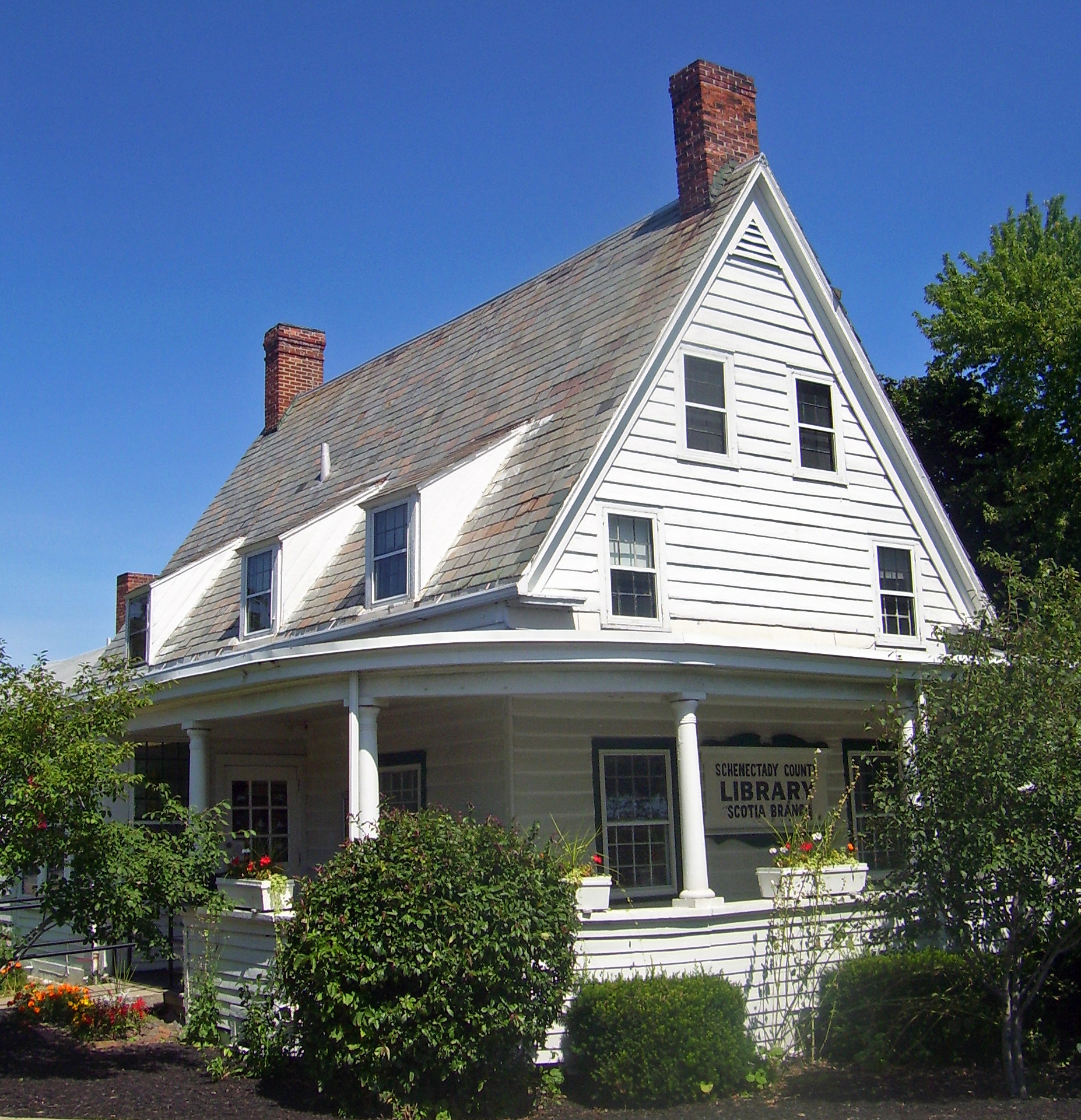
July 14, 2004 Mohawk Ave.
42°49′27″N 73°57′35″W / 42.824167°N 73.959722°WScotia Rare Dutch heavy timber frame house, built in 1730s, is now Scotia's branch of the county public library 27 Joseph Green Farmhouse October 11, 1984 NY 159
42°49′43″N 74°10′43″W / 42.828611°N 74.178611°WDuanesburg 28 Halladay Farmhouse October 11, 1984 US 20
42°45′59″N 74°12′49″W / 42.766389°N 74.213611°WDuanesburg 29 Hawes Homestead October 11, 1984 Herrick Rd.
42°47′35″N 74°12′39″W / 42.793056°N 74.210833°WDuanesburg 30 Hotel Van Curler 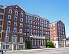
September 12, 1985 78 Washington Ave.
42°48′54″N 73°56′58″W / 42.815°N 73.949444°WSchenectady 1925 building now Elston Hall of the Schenectady County Community College 31 Howard Homestead October 11, 1984 McGuire School Rd.
42°46′39″N 74°13′44″W / 42.7775°N 74.228889°WDuanesburg 32 Jenkins House 
October 11, 1984 57 Main St.
42°44′46″N 74°11′19″W / 42.746111°N 74.188611°WDelanson 33 Jenkins Octagon House 
October 11, 1984 NY 395
42°45′31″N 74°11′07″W / 42.758611°N 74.185278°WDuanesburg 34 A.D. (Boss) Jones House 
October 11, 1984 McGuire School Rd.
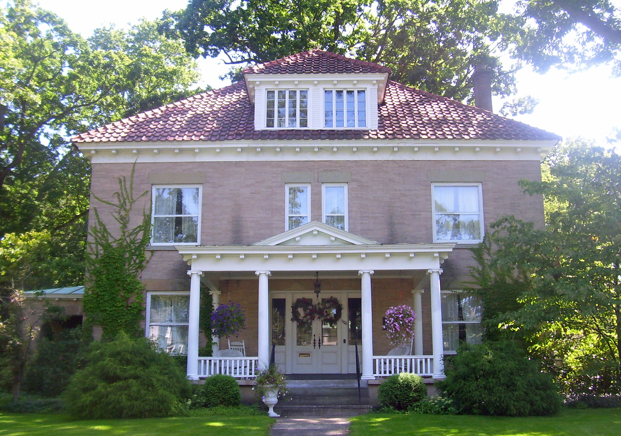
42°46′20″N 74°12′53″W / 42.772222°N 74.214722°WDuanesburg 35 George Westinghouse Jones House September 15, 2004 1944 Union St.
42°47′39″N 73°53′11″W / 42.794167°N 73.886389°WNiskayuna 36 Ladd Farmhouse October 11, 1984 Dare Rd.
42°47′18″N 74°13′33″W / 42.788333°N 74.225833°WDuanesburg 37 Irving Langmuir House 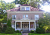
January 7, 1976 1176 Stratford Rd.
42°48′58″N 73°55′09″W / 42.816111°N 73.919167°WSchenectady Home of Irving Langmuir, 1932 Nobel laureate in chemistry and first industrial chemist so honored. During his career at GE, improved functioning of light bulb, developed concentric model of atom, co-developed cloud seeding and was among first scientists to work with plasmas. 38 George Lasher House October 11, 1984 Levey Rd.
42°50′11″N 74°09′16″W / 42.836389°N 74.154444°WDuanesburg 39 Alexander Liddle Farmhouse October 11, 1984 Gamsey Rd.
42°46′42″N 74°12′26″W / 42.778333°N 74.207222°WDuanesburg 40 Robert Liddle Farmhouse October 11, 1984 Little Dale Farm Rd.
42°46′34″N 74°07′21″W / 42.776111°N 74.1225°WDuanesburg 41 Thomas Liddle Farm Complex October 11, 1984 Eaton Corners Rd.
42°47′51″N 74°14′23″W / 42.7975°N 74.239722°WDuanesburg 42 Mabee House 
May 22, 1978 S of Rotterdam Junction on NY 5S
42°51′56″N 74°01′56″W / 42.865556°N 74.032222°WRotterdam Junction 43 Macomber Stone House October 11, 1984 Barton Hill Rd.
42°43′17″N 74°12′52″W / 42.721389°N 74.214444°WDuanesburg 44 Mariaville Historic District October 11, 1984 NY 159
42°49′42″N 74°08′08″W / 42.828333°N 74.135556°WDuanesburg 45 Niskayuna Railroad Station 
November 19, 2007 N. side River Rd., Lyons Park
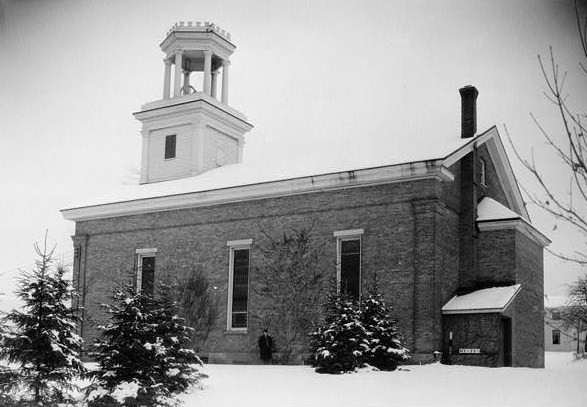
42°46′47″N 73°49′25″W / 42.779722°N 73.823611°WNiskayuna 46 Niskayuna Reformed Church 
April 18, 1979 3041 Troy-Schenectady Rd.
42°46′34″N 73°49′56″W / 42.776111°N 73.832222°WNiskayuna 47 North Mansion and Tenant House 
April 24, 1987 North Mansion Rd.
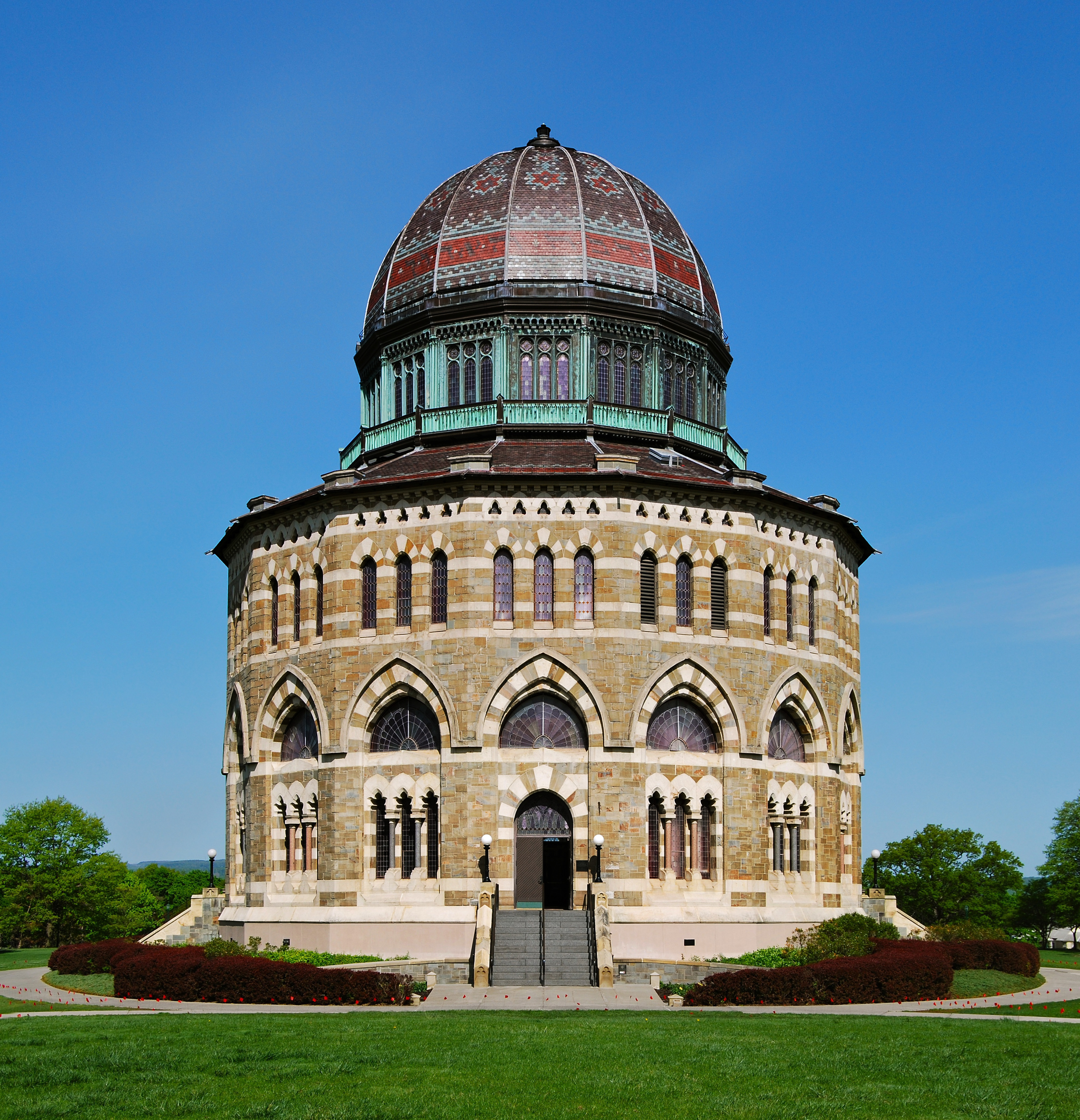
42°45′13″N 74°06′52″W / 42.753611°N 74.114444°WDuanesburg 48 Nott Memorial Hall 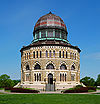
May 5, 1972 Union College campus
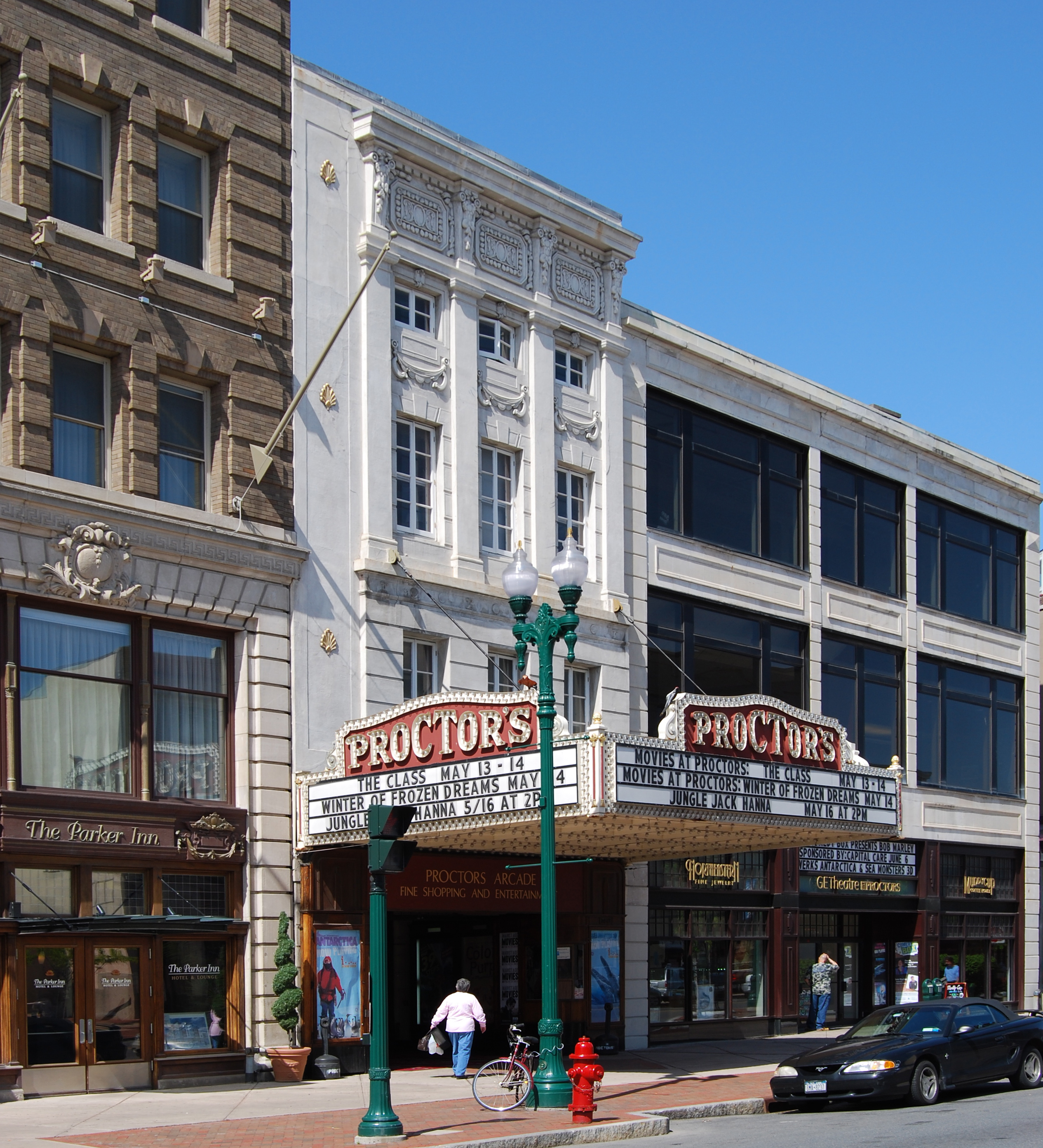
42°49′02″N 73°55′49″W / 42.817222°N 73.930278°WSchenectady 16-sided domed building at center of campus considered fine example of Victorian Gothic. Has had many uses over years; completely restored in 1990s. 49 F. F. Proctor Theatre and Arcade 
October 4, 1979 432 State St.
42°48′44″N 73°56′31″W / 42.812222°N 73.941944°WSchenectady 1926 theater recently renovated. One of the most lavish in nation when built; hosted first public demonstration of television in 1930. 50 Quaker Street Historic District 
October 11, 1984 Schoharie Tpk., Gallupville and Darby Hill Rds.
42°44′01″N 74°11′16″W / 42.733611°N 74.187778°WDuanesburg 51 Reformed Presbyterian Church Parsonage October 11, 1984 Duanesburg Churches Rd.
42°46′16″N 74°09′26″W / 42.771111°N 74.157222°WDuanesburg 52 Rosendale Common School Rosendale Common SchoolJuly 19, 2010 2572 Rosendale Rd.
42°47′46″N 73°51′31″W / 42.796111°N 73.858611°WNiskayuna vicinity New listing; refnum 10000482 53 Schenectady Armory 
March 2, 1995 125 Washington Ave.
42°48′48″N 73°56′58″W / 42.813333°N 73.949444°WSchenectady Intact 1936 Art Deco armory, unusually located in center (at the time) of city rather than outskirts 54 Schenectady City Hall and Post Office 
October 11, 1978 Jay St.
42°48′51″N 73°56′22″W / 42.814167°N 73.939444°WSchenectady 1931 McKim, Mead and White building with window arches matching nearby post office 55 Seeley Farmhouse May 23, 1978 2 Freeman's Bridge Rd.
42°49′54″N 73°55′50″W / 42.831667°N 73.930556°WGlenville 56 Sheldon Farmhouse October 11, 1984 NY 7
42°43′27″N 74°15′20″W / 42.724167°N 74.255556°WDuanesburg 57 Shute Octagon House 
October 11, 1984 McGuire School Rd.
42°46′28″N 74°13′10″W / 42.774444°N 74.219444°WDuanesburg 58 Stockade Historic District 
April 3, 1973 Roughly bounded by Mohawk River, RR tracks, and Union St.
42°49′07″N 73°56′47″W / 42.818611°N 73.946389°WSchenectady Oldest section of city, with many houses dating to 18th century 59 Swart House and Tavern January 4, 2007 130 Johnson Rd.
42°53′10″N 74°03′02″W / 42.886111°N 74.050556°WGlenville 60 Union Street Historic District 
November 17, 1982 Union St. from Hudson River to Phoenix Ave.
42°48′46″N 73°55′41″W / 42.812778°N 73.928056°WSchenectady Intact 19th century development along main axis of city's expansion during that period. 61 US Post Office-Schenectady 
May 11, 1989 Jay and Liberty Sts.
42°48′53″N 73°56′21″W / 42.814722°N 73.939167°WSchenectady 1912 neoclassical building added onto during Depression 62 US Post Office-Scotia Station 
May 11, 1989 224 Mohawk Ave.
42°49′38″N 73°57′59″W / 42.827222°N 73.966389°WScotia Detailed Colonial Revival post office built 1939–40 63 Vale Cemetery and Vale Park 
September 24, 2004 907 State St., Nott Terrace
42°48′26″N 73°55′45″W / 42.807222°N 73.929167°WSchenectady (Article on the combo of Vale Cemetery AND the park is needed) 64 Joseph Wing Farm Complex October 11, 1984 NY 30
42°43′47″N 74°17′10″W / 42.729722°N 74.286111°WDuanesburg 65 William R. Wing Farm Complex October 11, 1984 US 20
42°45′52″N 74°14′15″W / 42.764444°N 74.2375°WDuanesburg See also
References
- ^ The latitude and longitude information provided in this table was derived originally from the National Register Information System, which has been found to be fairly accurate for about 99% of listings. For about 1% of NRIS original coordinates, experience has shown that one or both coordinates are typos or otherwise extremely far off; some corrections may have been made. A more subtle problem causes many locations to be off by up to 150 yards, depending on location in the country: most NRIS coordinates were derived from tracing out latitude and longitudes off of USGS topographical quadrant maps created under North American Datum of 1927, which differs from the current, highly accurate GPS system used by Google maps. Chicago is about right, but NRIS longitudes in Washington are higher by about 4.5 seconds, and are lower by about 2.0 seconds in Maine. Latitudes differ by about 1.0 second in Florida. Some locations in this table may have been corrected to current GPS standards.
- ^ "National Register of Historic Places: Weekly List Actions". National Park Service, United States Department of the Interior. Retrieved on November 18, 2011.
- ^ Numbers represent an ordering by significant words. Various colorings, defined here, differentiate National Historic Landmark sites and National Register of Historic Places Districts from other NRHP buildings, structures, sites or objects.
Categories:- National Register of Historic Places in New York by county
- Buildings and structures in Schenectady County, New York
-


Wikimedia Foundation. 2010.