- Delaware Park-Front Park System
-
Delaware Park-Front Park System
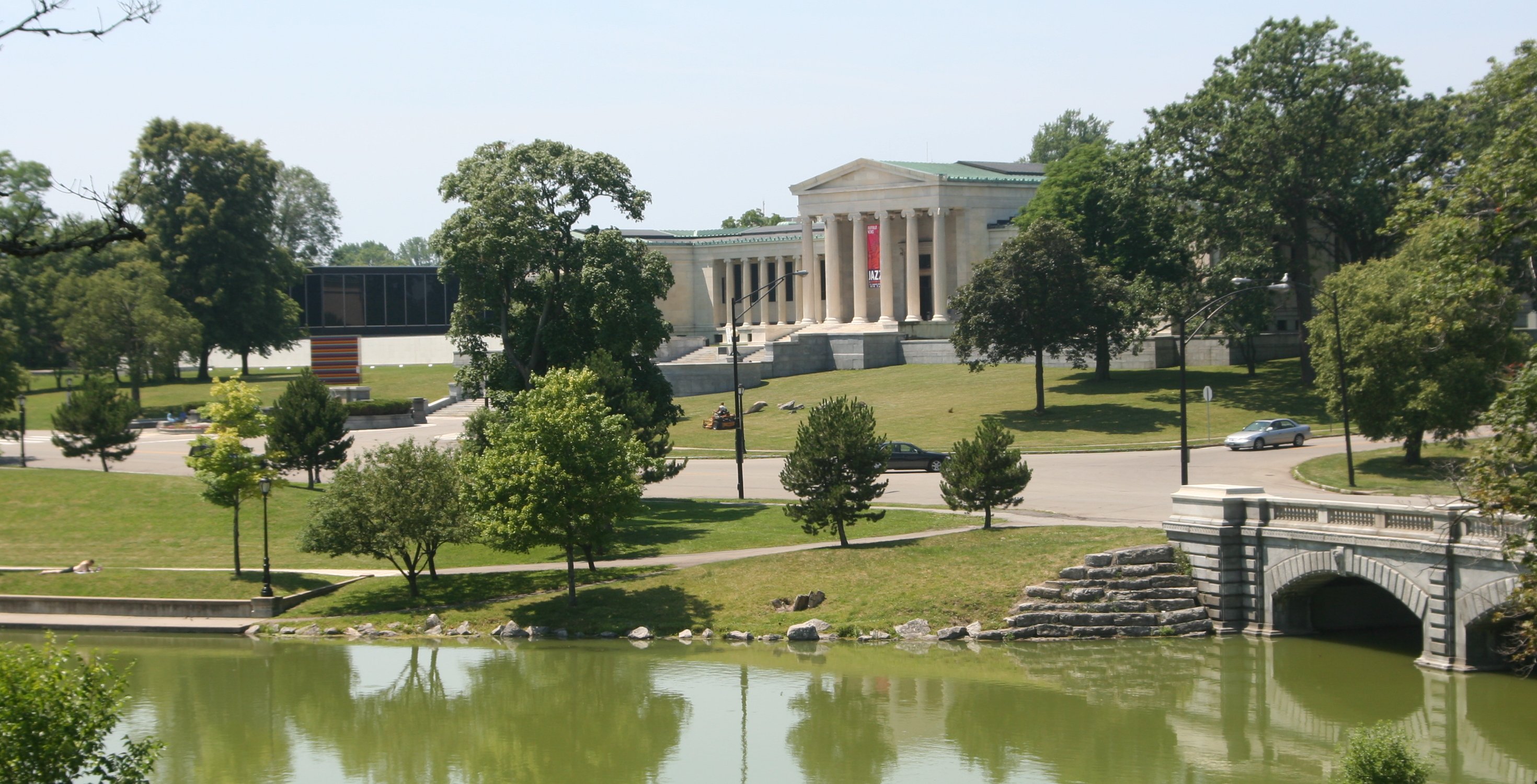
 A View of Hoyt Lake in Delaware Park

Location: Front Park, Porter Ave. to Symphony Cir., N along Richmond Ave., Bidwell Pkwy., Gates Cir. and Delaware Park, Buffalo, New York Coordinates: 42°55′10″N 78°52′47″W / 42.91944°N 78.87972°WCoordinates: 42°55′10″N 78°52′47″W / 42.91944°N 78.87972°W Area: 505.9 acres (204.7 ha) Architect: Olmsted, Frederick Law; Vaux, Calvert Governing body: Local MPS: Olmsted Parks and Parkways TR NRHP Reference#: 82005029[1] Added to NRHP: March 30, 1982 Delaware Park-Front Park System is a historic park system and national historic district located in the northern and western sections of Buffalo in Erie County, New York. The park system was designed by Frederick Law Olmsted and Calvert Vaux and developed between 1868 and 1876.
The system encompasses the following parts:[2]
- 1) Delaware Park: It is the centerpiece of the Buffalo, New York parks system and located in the North Buffalo neighborhood. The 376-acre (152 ha) park was named simply The Park by Olmsted; it was later renamed Delaware Park because of its proximity to Delaware Avenue, Buffalo's mansion row. It is divided into two areas: the 243-acre (98 ha) "Meadow Park" on the east and the 133-acre (54 ha) "Water Park", with what was originally a 43-acre (17 ha) lake ("Gala Water"[3]), on the west. The 12-acre (4.9 ha) ravine and picnic grove on the south side of the lake comprise a subdivision of the latter. A widening of Scajaquada Creek, which flows westward through the park, is called Hoyt Lake (originally Mirror Lake). The lake was a feature during the Pan-American Exposition. The Scajaquada Expressway bisects the park west to east.
- The Albright-Knox Art Gallery occupies the park's western edge, overlooking Hoyt Lake, and the Buffalo and Erie County Historical Society is situated on its northern edge, overlooking Scajaquada Creek. The park is also home to a noted replica of Michelangelo's David. The park is home to Shakespeare in Delaware Park, a summer tradition since the mid-1970s, and the second largest free outdoor Shakespeare festival in the United States (after New York City's). It is also the location of the Buffalo Zoo on the east side of "Meadow Park. The park also has a golf course, four baseball diamonds, tennis courts, and a soccer field.[2]
- Contributing structures are: Caretakers Cottage (1889); Lincoln Parkway Bridge (1900),designed by Green and Wicks; Rose Garden Pergola (1912); Stone Bridge (ca. 1887), the only remaining structure from the original Olmsted plan; Parkside Lodge (1914); Rumsey Shelter House (1900); Main Zoo Building (1935-1940); Shelter House (ca. 1900); and Elephant House (ca. 1912).[2] Located adjacent to the park are the Parkside East Historic District and Parkside West Historic District, both added to the National Register of Historic Places in 1986.[1]
- 2) Gates Circle (originally Chapin Place): Originally a 5-acre (2.0 ha) plot, 500 by 420 feet (150 by 130 m), at the intersection of Delaware Avenue, Lafayette Avenue, and Chapin Parkway. The circle's center contains a monumental sunken fountain constructed in 1904.[2]
- 3) Chapin Parkway: Connects Gates Circle and Soldier's Place; 1,904 feet (580 m) in length.[2]
- 4) Soldier's Place: Consists of an area 700 feet (210 m) in diameter, 8.8 acres (3.6 ha), at the juncture of Bidwell Parkway, Lincoln Parkway, Bird Avenue, and Chapin Parkway. Frank Lloyd Wright's William R. Heath House (1904) overlooks the circle at Bird Avenue.[2]
- 5) Lincoln Parkway: A 200-foot-wide (61 m), 9-acre (3.6 ha) thoroughfare, connecting Soldier's Place to Delaware Park; 1,965 feet (599 m) in length.[2]
- 6) Bidwell Parkway: A 200-foot-wide (61 m), 10.7-acre (4.3 ha) thoroughfare, connecting Colonial Circle to Soldier's Place; 2,323 feet (708 m) in length. At its intersection with Soldier's Place is a large bronze sculpture by Larry Griffiths titled Birds in Flight (1980).[2]
- 7) Colonial Circle (formerly Bidwell Place): A 5.4-acre (2.2 ha) plot, 510 by 465 feet (160 by 142 m), at the intersection of Richmond Avenue, Bidwell Parkway, and Lafayette Street. The circle's center contains an equestrian statue of General Daniel D. Bidwell.[2]
- 8) Richmond Avenue (originally The Avenue): Connects Symphony Circle to Colonial Circle; 100 feet (30 m) wide and 6,022 feet (1,836 m) in length. It traverses Ferry Circle at West Ferry Street.[2]
- 9) Ferry Circle: A 300-foot-diameter (91 m) circle at the intersection of West Ferry Street, Massachusetts Street, and Richmond Avenue.[2]
- 10) Symphony Circle: A 500-foot-diameter (150 m), 4.5-acre (1.8 ha) circle at the juncture of Porter Avenue with Richmond Avenue, North Street, Pennsylvania Street, and Wadsworth Street. Kleinhans Music Hall is located on the southeast side of the circle; it was designated a National Historic Landmark in 1989.[1] The circle is located within the Allentown Historic District.[2]
- 11) Porter Avenue: A former city street incorporated into the parks system; connects Symphony Circle to Columbus Park and Front Park.[2]
- 12) Columbus Park (formerly Prospect Park): A park located at the intersection of Niagara Street and Porter Avenue; the site of the Connecticut Street Armory. The park is located adjacent to D'Youville College and is home to a branch of the Buffalo & Erie County Public Library. The Shelter House (ca. 1908) is a contributing structure.[2]
- 13) Front Park (formerly The Front): A 32-acre (13 ha) park located at the beginning of the Niagara River and overlooking Lake Erie. The park is home to the U.S. entrance to the Peace Bridge, erected in 1927 on the site of the former Fort Porter, and includes baseball diamonds, large open playing fields, and tennis courts. The park contains a monument to Commodore Oliver Hazard Perry. The Picnic Shelter (ca. 1900) is a contributing structure.[2]
The park system was listed on the National Register of Historic Places in 1982.[1]
See also
References
- ^ a b c d "National Register Information System". National Register of Historic Places. National Park Service. 2009-03-13. http://nrhp.focus.nps.gov/natreg/docs/All_Data.html.
- ^ a b c d e f g h i j k l m n o Claire L. Ross (December 1981). "National Register of Historic Places Registration: Olmsted Parks and Parkways Thematic Resources". New York State Office of Parks, Recreation and Historic Preservation. http://www.oprhp.state.ny.us/hpimaging/hp_view.asp?GroupView=100208. Retrieved 2009-06-14. See also: "Notifications". http://www.oprhp.state.ny.us/hpimaging/hp_view.asp?GroupView=100206. and "Meeting minutes". http://www.oprhp.state.ny.us/hpimaging/hp_view.asp?GroupView=100207.
- ^ Kowsky, Francis R. (2010-03-31). "Municipal Parks and City Planning: Frederick Law Olmsted's Buffalo Park and Parkway System". http://preserve.bfn.org/bam/kowsky/kowold/.
External links
- Buffalo Olmsted Parks Conservancy
- Olmsted Parks in Buffalo from Stanton M. Broderick
- Buffalo as an Architectural Museum, "Municipal Parks and City Planning: Frederick Law Olmsted's Buffalo Park and Parkway System," by Francis R. Kowsky, Reprinted with permission from the Journal of the Society of Architectural Historians, March 1987.
Buffalo, New York Attractions Entertainment Military and municipal Neighborhoods Allentown • Black Rock • Canal Street • Delaware District • East Lovejoy • East Side • North Buffalo • Riverside • South Buffalo • University Heights • Upper West SideResearch and education People Grover Cleveland • Carl Paladino • Millard Fillmore • Jack Kemp • O. J. Simpson • Gilbert Perreault • Bob McAdoo • Ralph Wilson • Warren Spahn • Jack Yellen • Jim Kelly • Thurman Thomas • Bruce Smith • Seymour Knox I • Seymour Knox II • Seymour Knox III • Timothy McVeigh • Goo Goo Dolls • Tim Russert • Wolf Blitzer • Nelson Baker • Rick James • Ani DiFrancoShopping Walden Galleria • Boulevard Mall • McKinley Mall • Eastern Hills Mall • Fashion Outlets of Niagara Falls • Rainbow Centre Factory Outlet (defunct) • The Summit (defunct) • Lockport Mall (defunct)Other Buffalo Museum of Science • Buffalo Philharmonic Orchestra • Anchor Bar • Lafayette Square • The French Connection • Delaware Park • Niagara Square • FBI Buffalo Field Office • Buffalo Turkey TrotCategories:- Historic districts in New York
- National Register of Historic Places in New York
- Geography of Buffalo, New York
- Visitor attractions in Buffalo, New York
- Parks in Erie County, New York
- Historic districts in Erie County, New York


Wikimedia Foundation. 2010.