- Maryland Route 261
-
Maryland Route 261
Willows Road, Bayside Road, Chesapeake Avenue, 7th Avenue, Bay Avenue, Walnut Avenue, Lake Shore Drive, Friendship Road 
Route information Maintained by MDSHA Length: 12.86 mi[1][2] (20.70 km) Major junctions South end:  MD 263 near Parran
 MD 260 in Chesapeake Beach
North end:  MD 778 in Friendship
Highway system Maryland highway system
Interstate • US • State • Minor • Former • Turnpikes← MD 260MD 262  →
→Maryland Route 261 (MD 261) is a state highway in the U.S. state of Maryland. The route runs 12.86 mi (20.70 km) from Maryland Route 263 near Parran north to Maryland Route 778 in Friendship. MD 261 connects several Chesapeake Bay beach communities, including Chesapeake Beach and North Beach in northern Calvert County and Rose Haven in southern Anne Arundel County.
Contents
Route description
Calvert County
Maryland Route 261 begins at an intersection with Maryland Route 263 (Plum Point Road) where MD 261 and MD 263 west serve as the through route. The route heads northeast as a two-lane road with a speed limit of 40 mph (64 km/h) through an area of farms and scattered residences. After meeting Pond Woods Road, which connects with the concurrent Maryland Route 2 and Maryland Route 4 in Huntingtown, the road intersects Breezy Point Road. Breezy Point Road, which is unsigned Maryland Route 764 for its first 475 ft (145 m), leads to the Breezy Point beach community and marina.
Shortly after MD 261 passes Willows Road and Christiana Parrans Road, the road turns north to parallel the bay coast. After passing a few more tiny beach communities, the road enters and crosses the Chesapeake Beach facility of the U.S. Naval Research Laboratory. The main entrances are at an intersection with a firehouse-type flashing signal. The road next runs through Randle Cliff Beach, where MD 261 intersects Summer City Boulevard, which leads to Old Bayside Road. MD 261 then enters the town of Chesapeake Beach, where the name of the road changes to Bayside Road.
MD 261 through the southern part of Chesapeake Beach runs through a forested area that is part of Bayside Park. After crossing a small creek, the speed limit drops to 30 mph (48 km/h) and the road enters the populated part of town and meets the northern end of Old Bayside Road. After passing the Chesapeake Station Shopping Center, the road passes by Harbor Road and Mears Avenue. The former road leads to a marina and the former road leads to the Chesapeake Beach Railway Station, which is a museum and a restoration of the eastern terminus of the Chesapeake Beach Railway that connected the resort to Washington, D.C.. After crossing Fishing Creek, MD 261 expands to a three-lane road with center turn lane and passes Lynwood T. Kellam Memorial Recreational Park and the Chesapeake Beach Town Hall, then meets the eastern terminus of Maryland Route 260 (Chesapeake Beach Road) at a signalized intersection.
After continuing through the northern part of Chesapeake Beach, the speed limit drops to 25 mph (40 km/h) at 1st Street and the road enters North Beach. MD 261 is municipally-maintained within town. After passing North Beach Town Hall and Robert W. Callis Memorial Park, the road crosses 5th Street, which extends west out of the town toward the hamlet of Mount Harmony. MD 261 then turns east on 7th Street and north again on Bay Street. The route follows Bay Street north to an unnamed creek, where the road leaves North Beach and enters Anne Arundel County, where state maintenance resumes.
Anne Arundel County
Upon entering the new county, the name of MD 261 changes to Walnut Avenue and the speed limit increases to 30 mph (48 km/h) as the route heads north and then west through North Beach Park, a beach community with alphabetical plant-named streets. At Rose Haven, the road passes Charleston Avenue then turns left onto Lake Shore Drive and loops around Rose Haven Harbor, with the speed limit increasing to 40 mph (64 km/h) after passing California Avenue and leaving the residential area. The name of the road changes for the final time, to Friendship Road, as it leaves the Chesapeake Bay.
After heading west for a time, the road curves north, meets south-heading Boyds Turn Road, and passes the historic home Holly Hill. MD 261 then meets Fairhaven Road, which leads to Maryland Route 423, on a curve back to the west. After passing Prout Road, the route continues through an area of farms. After the speed limit drops to 30 mph (48 km/h), the road enters the unincorporated village of Friendship, where MD 261 comes to an end at Maryland Route 778 (Old Solomons Island Road). Friendship Road continues westward 1,000 ft (300 m) to a roundabout at Maryland Route 2 (Solomons Island Road).
History
What is now Maryland Route 261 was actually two different state routes: MD 261 in Calvert County and Maryland Route 613 in Anne Arundel County. Only the stretch of Maryland Route 261 in Chesapeake Beach was paved in 1927.[3] By 1933, the road was also paved between Willows Road near Plum Point and Randle Cliff Beach.[4] The gap between Randle Cliff Beach and Chesapeake Beach was closed in 1936, and the road was extended into North Beach.[5] By 1939, the designation of MD 261 was assigned to the road in Calvert County.[6] However, the road south of Willows Road to MD 263 was not state-maintained and extended to a point closer to Plum Point than it does now. The current stretch of MD 261 between its southern terminus and Willows Road was completed in 1950.[7]

MD 613 first appeared in 1936 on the road between Friendship and Boyds Turn Road.[5] Its designation was first marked on the 1939 Maryland state highway map.[6] At that time, there was no road at all between MD 613's eastern terminus and North Beach. MD 613 was extended east to Rose Haven in 1949.[8] By 1950, the road between Rose Haven and North Beach was under construction.[7] The road was completed by 1956.[9] It was not clear where MD 261 ended and where MD 613 began, but by 1970 MD 261 had taken over MD 613's routing and assumed its current course.[10]
Junction list
County Location Mile[1][2] Destinations Notes Calvert 7.45 mi (11.99 km)[2]
Parran 0.00 MD 263 (Plum Point Road) – Prince Frederick, Plum PointSouthern terminus 0.65 Pond Woods Road 1.22 Breezy Point Road Unsigned 
1.43 Willows Road 1.46 Christiana Parran Road Chesapeake Beach 3.41 Entrance to U.S. Naval Research Lab 3.91 Summer City Boulevard 5.20 Old Bayside Road 5.67 Harbor Road / Mears Avenue Chesapeake Beach Railway Station 6.04 MD 260 west (Chesapeake Beach Road) – Owings, Upper Marlboro6.58 1st Street North Beach 6.90 5th Street 7.00 7th Street  continues east on 7th Street
7.06 Bay Avenue continues north on Bay AvenueAnne Arundel 5.41 mi (8.71 km)[1]
Rose Haven 9.01 Charleston Avenue 9.32 California Avenue Friendship 11.13 Boyds Turn Road 11.45 Fairhaven Road To 
11.92 Prout Road 12.86 MD 778 (Old Solomons Island Road) – Annapolis, Owings
Friendship Road
Northern terminus Friendship Road continues to

References
- ^ a b c Maryland State Highway Administration (2008). "Highway Location Reference: Anne Arundel County" (PDF). http://apps.roads.maryland.gov/KeepingCurrent/performTrafficStudies/dataAndStats/hwyLocationRef/2008_hlr_all/co02.pdf. Retrieved 2010-01-10.
- ^ a b c Maryland State Highway Administration (2008). "Highway Location Reference: Calvert County" (PDF). http://apps.roads.maryland.gov/KeepingCurrent/performTrafficStudies/dataAndStats/hwyLocationRef/2008_hlr_all/co04.pdf. Retrieved 2010-01-10.
- ^ Maryland State Highway Administration (1927). "Map of Maryland" (JPG). http://www.mdhighwaycentennial.com/images/template/gallery/maps/1927SIDE1.jpg. Retrieved 2010-01-11.
- ^ Maryland State Highway Administration (1933). "Map of Maryland" (PDF). http://commons.wikimedia.org/wiki/File:Maryland_State_Highway_Map_-_1933.pdf. Retrieved 2010-01-11.
- ^ a b Maryland State Highway Administration (1936). "Map of Maryland" (PDF). http://commons.wikimedia.org/wiki/File:Maryland_State_Highway_Map_-_1936.pdf. Retrieved 2010-01-11.
- ^ a b Maryland State Highway Administration (1939). "Map of Maryland" (PDF). http://commons.wikimedia.org/wiki/File:Maryland_State_Highway_Map_-_1939.pdf. Retrieved 2010-01-11.
- ^ a b Maryland State Highway Administration (1950). "Map of Maryland" (PDF). http://commons.wikimedia.org/wiki/File:Maryland_State_Highway_Map_-_1950.pdf. Retrieved 2010-01-11.
- ^ Maryland State Highway Administration (1949). "Map of Maryland" (PDF). http://commons.wikimedia.org/wiki/File:Maryland_State_Highway_Map_-_1949.pdf. Retrieved 2010-01-11.
- ^ Maryland State Highway Administration (1956). "Map of Maryland" (PDF). http://commons.wikimedia.org/wiki/File:Maryland_State_Highway_Map_-_1956.pdf. Retrieved 2010-01-11.
- ^ Maryland State Highway Administration (1970). "Map of Maryland" (PDF). http://commons.wikimedia.org/wiki/File:Maryland_State_Highway_Map_-_1970.pdf. Retrieved 2010-01-11.
External links
Roads in Calvert County, Maryland State highways 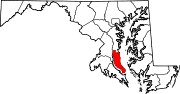 Categories:
- State highways in Maryland
- Roads in Anne Arundel County, Maryland
- Roads in Calvert County, Maryland


Wikimedia Foundation. 2010.