- U.S. Route 59
-
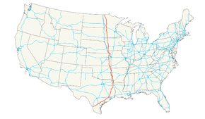
U.S. Route 59
Route information Length: 1,911 mi[1] (3,075 km) Existed: 1934[1] – present Major junctions South end: 
 I-35 / US 83 at Laredo, TX
 I-10 / I-45 at Houston, TX
 I-20 near Marshall, TX
 I-30 near Texarkana, TX
 I-40 at Sallisaw, OK
 I-44 near Afton, OK
 I-35 at Ottawa, KS

 I-70 / KTA at Lawrence, KS
 I-80 near Avoca, IA
 I-90 at Worthington, MN
 I-94 near Fergus Falls, MN
North end:  PTH 59 at Canadian border near Lancaster, MN
Highway system United States Numbered Highways
List • Bannered • Divided • ReplacedU.S. Route 59 is a north–south United States highway (though it is signed east–west in parts of Texas). A latecomer to the U.S. numbered route system, U.S. 59 is now a border-to-border route, Part of NAFTA Corridor Highway System. It parallels U.S. Route 75 for nearly its entire route, never much more than 100 miles (160 km) away, until it veers southwest in Houston, Texas. Its number is out of place since U.S. 59 is either concurrent with or entirely west of U.S. Route 71.
The highway's northern terminus is nine miles (14 km) north of Lancaster, Minnesota, at the Canadian border, where it continues as Manitoba Highway 59. Its southern terminus is in Laredo, Texas, at an interchange with Interstate 35 and U.S. Route 83 just north of the Mexican border.
Contents
Route description
Texas
Main article: U.S. Route 59 in Texas In Texas U.S. Route 59 is known as the Lloyd Bentsen Highway for the U.S. senator (1971-1993) and the Democratic vice-presidential nominee (1988).
From the southwestern suburbs of Houston to Downtown Houston, U.S. 59 is commonly referred to as the "Southwest Freeway," sometimes derisively as the "Southwest's Best Freeway." Supporting 371,000 vehicles per day,[2] it is one of the busiest freeways in the United States. U.S. 59 is known as the "Eastex Freeway" in the north/northeast part of the Houston region. On US-Mexico Border, it ends in Laredo, Texas in at an intersection with Interstate 35 which also ends at the Juarez-Lincoln International Bridge. After crossing the bridge into Mexico Mexican Federal Highway 85 starts at Nuevo Laredo which then runs through Mexico and Central America and ends at in Panama at the Panama Canal.
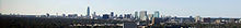 Uptown Houston Skyscrapers along U.S. Route 59
Arkansas
In Arkansas, U.S. 59 is concurrent with U.S. Route 71 from Interstate 30 at Texarkana to Acorn, and with U.S. Route 270 from Acorn to the Oklahoma state line.
Oklahoma
Main article: U.S. Route 59 in OklahomaU.S. 59 and U.S. Route 412 are co-signed for 10 miles (16 km) in Delaware County, Oklahoma.
U.S. 59 is co-signed with U.S. Route 270 from the Arkansas State Line to Heavener and U.S. Route 271 from Poteau to west of Spiro. Also with U.S. Route 64 in Sallisaw
Kansas
U.S. 59 enters the state just south of Chetopa and runs nearly directly north across the state. U.S. 59 runs concurrently with U.S. 169 starting about four miles (6 km) south of Garnett and diverges north again immediately south of Garnett. The intersection immediately south of Garnett used to be a "braided" intersection with Stop and Yield signs. It was identified as a high crash location in 2001, and was rebuilt as a roundabout that opened in April 2006.[3] The Kansas Department of Transportation is rebuilding or planning to rebuild several other rural intersections as roundabouts for increased safety.[4][5] U.S. 59 passes through Lawrence, home of the University of Kansas Jayhawks. The street name of U.S. 59 in Lawrence is Iowa Street, then 6th street as it joins U.S. 40 and jogs east to cross the Kansas River near downtown. North of the bridge, it splits with U.S. 40 as it joins U.S. 24 briefly and jogs back west before resuming a northerly course. It continues north to Nortonville, then northeast to Atchison, where it crosses the Missouri River over the Amelia Earhart Bridge. U.S.59 is currently being rebuilt and rerouted just to the east between Lawrence and Ottawa as a divided highway, as the current road has become one of the most dangerous stretches of highway in the state.[1]
Missouri
In Missouri, U.S. 59 roughly follows the Missouri River in the northwest corner of the state, from its entrance at Winthrop. In Saint Joseph the highway is paired with Interstate 229 through downtown. U.S. 59 departs from I-229 as Saint Joseph Avenue, joining with U.S. Route 71 at Interstate 29. The two highways then separate in Savannah. U.S. 59 then follows Interstate 29 very closely until turning northward at Craig. It exits the state ten miles (16 km) north of Tarkio.
Iowa
In Iowa, U.S. 59 is a main north–south artery in the far western part of the state. It enters Iowa south of Shenandoah, Everly Brothers Ave. in Shenandoah's city limits, and junctions Interstate 80 at Avoca. It passes through the county seats of Harlan, Denison, and Cherokee. Except for small stretches of expressway near Avoca, Denison, and Holstein, the entire length of U.S. 59 in Iowa is an undivided two-lane road. U.S. 59 exits the state near Hawkeye Point, the highest point in the state of Iowa.
Minnesota
U.S. 59 enters Minnesota south of Worthington, just one mile (1.6 km) east of Bigelow. It passes through rural western Minnesota for its entire length in the state. Some cities along the way include Currie, Marshall, Clarkfield, Montevideo, and Morris. U.S. 59 overlaps Interstate 94 in the Fergus Falls area. North of Fergus Falls, U.S. 59 passes through Pelican Rapids, Detroit Lakes and Thief River Falls before ending at the Canadian border north of Lancaster.
The Minnesota section of U.S. 59 is legally defined as all or part of Routes 265, 16, 17, 88, 66, 144, 3, 30, and 174 in Minnesota Statutes §§ 161.115(19), (75), and (196) and 161.114(2).[6][7]
History
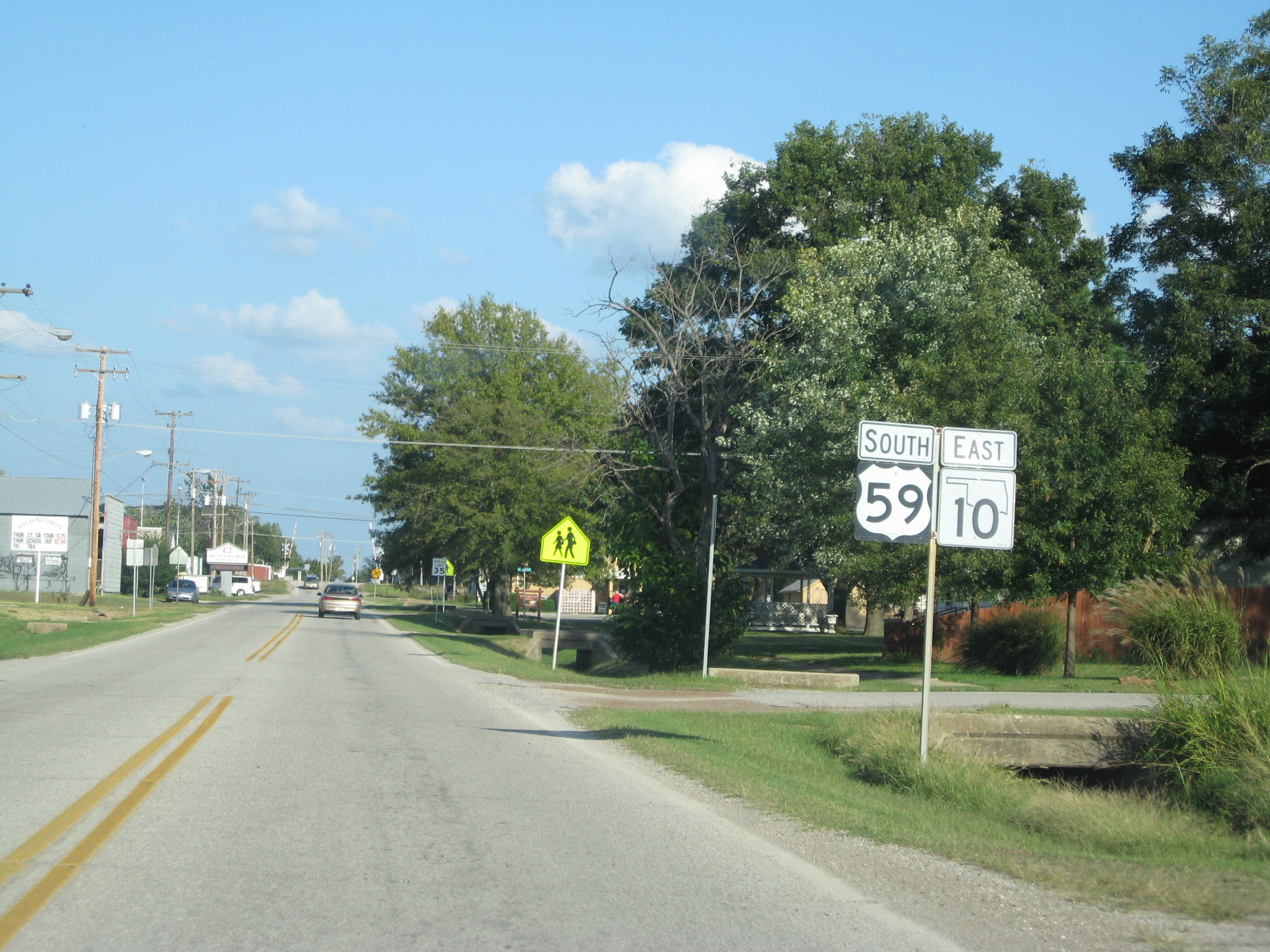
 U.S. 59 and State Highway 10 in Welch, Oklahoma
In 1934, a coalition of government officials from Missouri, Iowa, and Minnesota agreed to sign the current U.S. Route 59 as Highway 73 in an attempt to extend U.S. Route 73 north from Atchison, Kansas. However, AASHO approved the route as U.S. Route 59 instead.[8]
The part in Missouri was defined in 1922 as Route 52 from Kansas to St. Joseph, Route 1 from St. Joseph to Tarkio, and Route 61 from Tarkio to Iowa. Route 61 became Route 9 in 1926, and Route 52 became part of Route 4 in the late 1920s, before being removed in favor of U.S. 59 in the 1930s.
U.S. 59 originally crossed into North Dakota at Pembina until the early 1950s.[citation needed]
Historic termini
Before the 1960s, U.S. 59 headed northwest to U.S. 75, crossed the Red River of the North at St. Vincent and terminated at U.S. 81 in Pembina, North Dakota. A new highway and border crossing was built north of Lancaster on the present alignment. The former segment of U.S. 59 between Lancaster and U.S. 75 became Kittson County 6, and the extremely short segment between U.S. 75 and U.S. 81 became Minnesota State Highway 171 and North Dakota Highway 59. ND Route 59 still exists in Pembina from the MN-ND border to Interstate 29.
From 1934 to 1935, the U.S. 59 designation referred to a 50-mile (80 km)-long route across southeastern Minnesota, from Lake City, Minnesota, to the Iowa border just short of Chester, Iowa. That entire route is now part of U.S. Route 63, and nowhere close to the present U.S. 59, established in 1935.[1]
Future
A large portion of U.S. 59 is proposed to become part of the future extension of Interstate 69 through Texas, allowing the current alignment and right-of-way to be upgraded without the need for extensive eminent domain proceedings.[9]
Major intersections
- Interstate 35 in Laredo, Texas
 Interstate 37 east of George West, Texas
 Alternate 90 in Sugar Land, Texas
 Interstate 610 in Houston, Texas (twice)
- Interstate 45 in Houston, Texas
- Interstate 10 in Houston, Texas
- Interstate 20 south of Marshall, Texas
- Interstate 30 in Texarkana
- Interstate 40 in Sallisaw, Oklahoma
- Interstate 44 near Afton, Oklahoma
- Interstate 70 in Lawrence, Kansas
 Interstate 229 in St. Joseph, Missouri (concurrent for 2 miles (3 km))
 Interstate 29 north of St. Joseph, Missouri (concurrent for 3 miles (5 km))
- Interstate 229 north of St. Joseph, Missouri, at intersection of I-29 and I-229
- Interstate 29, four times between Craig, Missouri, and Savannah, Missouri, including a 2-mile (3.2 km) long concurrency near Richville, Missouri
- Interstate 80 in Avoca, Iowa
- Interstate 90 in Worthington, Minnesota*
- Interstate 94 in Fergus Falls, Minnesota
See also
Bannered routes
- U.S. Route 59 Business in Carthage, Texas
- U.S. Route 59 Business in Cleveland, Texas
- U.S. Route 59 Business in Lufkin, Texas
- U.S. Route 59 Business in Nacogdoches, Texas
- U.S. Route 59 Business in Texarkana, Texas decommissioned
- U.S. Route 59 Business in Victoria, Texas
Related U.S. Routes
References
- ^ a b c Droz, Robert V. U.S. Highways: From U.S. 1 to (U.S. 830). March 9, 2006.
- ^ TexasFreeway.com > Houston
- ^ Slide 1
- ^ http://www.ksdot.org/burtrafficeng/Roundabouts/Roundabout_Guide/Appendix_C.pdf
- ^ Slide 1
- ^ 161.115, Minnesota Statutes 2006
- ^ 161.114, Minnesota Statutes 2006
- ^ Iowa Highways - U.S. 73
- ^ I69Info.com: "New" and "Old" Terrain
External links
 Main U.S. Routes
1 2 3 4 5 6 7 8 9 10 11 12 13 14 15 16 17 18 19 20 21 22 23 24 25 26 27 28 29 30 31 32 33 34 35 36 37 38 40 41 42 43 44 45 46 48 49 50 51 52 53 54 55 56 57 58 59 60 61 62 63 64 65 66 67 68 69 70 71 72 73 74 75 76 77 78 79 80 81 82 83 84 85 87 89 90 91 92 93 94 95 96 97 98 99 101 163 400 412 425 Lists U.S. Routes • Bannered • Divided • Bypassed Browse numbered routes ←  SH 57
SH 57TX SH 59  →
→←  Hwy. 58
AR Hwy. 59  →
→←  SH-58
SH-58OK SH-59  →
→←  K-58
K-58KS K-60  →
→←  Route 58
MO Route 59  →
→←  Iowa 58
IA Iowa 60  →
→←  MN 58
MN 58MN MN 60  →Categories:
- U.S. Route 59
- U.S. Highway System
- U.S. Highways in Kansas
- U.S. Highways in Missouri
- U.S. Highways in Minnesota
- U.S. Highways in Iowa
- U.S. Highways in Arkansas
- U.S. Highways in North Dakota
- Interstate 69


Wikimedia Foundation. 2010.