- National Register of Historic Places listings in Delaware County, Ohio
-
 Location of Delaware County in Ohio
This is a list of the National Register of Historic Places listings in Delaware County, Ohio.
This is intended to be a complete list of the properties and districts on the National Register of Historic Places in Delaware County, Ohio, United States. The locations of National Register properties and districts for which the latitude and longitude coordinates are included below, may be seen in a Google map.[1]
There are 56 properties and districts listed on the National Register in the county. Another property was once listed but has been removed.
-
- This National Park Service list is complete through NPS recent listings posted November 10, 2011.[2]
Current listings
[3] Landmark name [4] Image Date listed Location City or town Summary 1 Austin Hall 
March 18, 1985 Ohio Wesleyan University, W. Central Ave. and Elizabeth St.
40°18′06″N 83°04′37″W / 40.301667°N 83.076944°WDelaware 2 John Baker Tavern September 6, 2006 4151 State Route 203, in Radnor
40°22′46″N 83°08′58″W / 40.379444°N 83.149444°WRadnor Township 3 George Bieber House and Farm 
October 3, 1991 2010 Stratford Rd., south of Delaware
40°15′56″N 83°03′53″W / 40.265556°N 83.064722°WDelaware Township 4 Building at 101 North Franklin Street November 25, 1980 101 N. Franklin St.
40°24′38″N 82°57′18″W / 40.4105°N 82.955°WAshley 5 Building at 223 West High Street November 25, 1980 223 W. High St.
40°24′33″N 82°57′41″W / 40.409167°N 82.961389°WAshley 6 Building at 500 East High Street November 25, 1980 500 E. High St.
40°24′32″N 82°56′57″W / 40.408889°N 82.949167°WAshley 7 Building at 505 East High Street November 25, 1980 505 E. High St.
40°24′32″N 82°56′54″W / 40.408889°N 82.948333°WAshley 8 Center Inn January 11, 1983 Southeast of Sunbury on State Route 37
40°13′01″N 82°48′02″W / 40.216944°N 82.800556°WTrenton Township 9 Chambers Road Covered Bridge November 21, 1974 1.5 mi (2.4 km) northeast of Olive Green
40°20′17″N 82°49′05″W / 40.338056°N 82.818056°WPorter Township 10 John Cook Farm April 11, 1977 East of Harlem at Miller Paul Rd. and Gorsuch Rd.
40°09′05″N 82°49′26″W / 40.151389°N 82.823889°WHarlem Township 11 Samuel Cooper Farmhouse May 6, 1993 695 Lawrence Rd., south of Radnor
40°19′33″N 83°09′33″W / 40.325833°N 83.159167°WRadnor Township 12 Crist Tavern Annex-Millworkers Boarding House 
March 25, 1994 2966 Olentangy River Rd., south of Delaware
40°15′20″N 83°03′51″W / 40.255556°N 83.064167°WDelaware Township 13 Marcus Curtiss Inn 
December 12, 1976 South of Galena at 3860 Sunbury Rd.
40°11′30″N 82°52′26″W / 40.191667°N 82.873889°WGenoa Township 14 Delaware County Courthouse 
May 22, 1973 N. Sandusky St. and Central Ave.
40°18′06″N 83°04′06″W / 40.301667°N 83.068333°WDelaware 15 Delaware County Jail and Sheriff's Residence 
July 12, 1990 20 W. Central Ave.
40°18′06″N 83°04′09″W / 40.301667°N 83.069167°WDelaware 16 Delaware Public Library 
January 11, 1983 101 N. Sandusky St.
40°18′08″N 83°03′56″W / 40.302222°N 83.065556°WDelaware 17 John Detwiller Tavern and Farmstead April 16, 1993 2877 N. State Route 257, west of Radnor
40°22′00″N 83°11′19″W / 40.366667°N 83.188611°WThompson Township 18 Edwards Gymnasium/Pfieffer Natatorium 
March 18, 1985 Ohio Wesleyan University Main Campus, S. Sandusky St.
40°17′41″N 83°04′03″W / 40.294722°N 83.0675°WDelaware 19 Elliott Hall, Sturges Library, and Merrick Hall 
April 23, 1973 Ohio Wesleyan University campus
40°17′46″N 83°03′58″W / 40.296111°N 83.066111°WDelaware 20 Felkner-Anderson House February 11, 1988 9716 Fontanelle Rd., northwest of Ostrander
40°17′02″N 83°14′20″W / 40.283889°N 83.238889°WScioto Township 21 Gooding House and Tavern July 27, 2005 7669 Stagers Loop
40°10′53″N 83°01′29″W / 40.181389°N 83.024722°WOrange Township 22 Greenwood Farm April 17, 1979 North of Delaware off U.S. Route 42
40°18′42″N 83°03′41″W / 40.311667°N 83.061389°WDelaware Township 23 High House February 13, 1986 2360 Panhandle Rd., north of Delaware
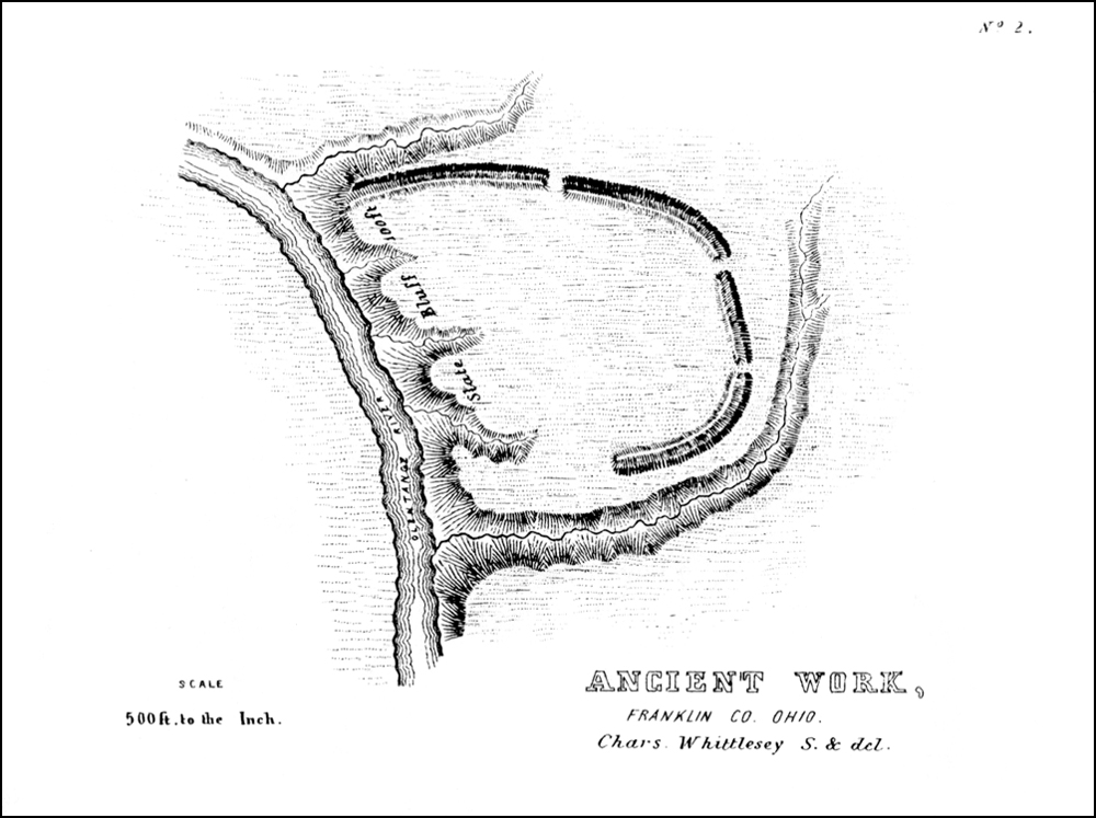
40°19′51″N 83°03′44″W / 40.330833°N 83.062222°WTroy Township 24 Highbank Park Works 
February 15, 1974 On a bluff above the eastern bank of the Olentangy River
40°8′27.6″N 83°1′51.6″W / 40.141°N 83.031°W[5]Orange Township 25 Highbanks Metropolitan Park Mounds I and II March 19, 1975 Eastern side of the Olentangy River, north of Worthington and east of Powell[6] Orange Township 26 Historic Northwest District 
February 29, 1996 Roughly bounded by Pennsylvania Ave., N. Sandusky St., W. William St., Elizabeth St., W. Fountain St., and N. Franklin St.
40°18′30″N 83°04′07″W / 40.308333°N 83.068611°WDelaware 27 Diadatus Keeler House February 28, 1979 Southeast of Galena at 4567 Red Bank Rd.
40°10′45″N 82°51′50″W / 40.179167°N 82.863889°WGenoa Township 28 Samuel Lewis Farmhouse April 16, 1993 5979 Radnor Rd., west of Radnor
40°22′59″N 83°11′00″W / 40.383056°N 83.183333°WRadnor Township 29 Limestone Vale 
October 2, 1978 3490 Olentangy River Rd., south of Delaware
40°14′52″N 83°03′38″W / 40.247778°N 83.060556°WLiberty Township 30 Forrest Meeker House and Farm 
October 3, 1991 2690 Stratford Rd., south of Delaware
40°15′31″N 83°03′51″W / 40.258611°N 83.064167°WDelaware Township 31 Mill Worker House No. 1 
October 3, 1991 2665 Stratford Rd., south of Delaware
40°15′32″N 83°03′48″W / 40.258889°N 83.063333°WDelaware Township 32 Mill Worker House No. 3 
October 3, 1991 2505 Stratford Rd., south of Delaware
40°15′38″N 83°03′47″W / 40.260556°N 83.063056°WDelaware Township 33 Mill Worker House No. 4 
October 3, 1991 2441 Stratford Rd., south of Delaware
40°15′39″N 83°03′47″W / 40.260833°N 83.063056°WDelaware Township 34 Mill Worker House No. 5 
October 3, 1991 2441 Stratford Rd., south of Delaware
40°15′40″N 83°03′47″W / 40.261111°N 83.063056°WDelaware Township 35 Edward E. Neff House 
January 28, 1988 123 N. Franklin St.
40°18′10″N 83°04′09″W / 40.302778°N 83.069167°WDelaware 36 O'Shaughnessy Dam and Bridge 
July 5, 1990 County Road 126 between State Routes 257 and 745, east of Shawnee Hills
40°09′14″N 83°07′34″W / 40.153889°N 83.126111°WConcord and Liberty Townships 37 Ohio Wesleyan University Student Observatory 
March 18, 1985 Ohio Wesleyan University, W. William St.
40°17′55″N 83°04′35″W / 40.298611°N 83.076389°WDelaware 38 Norman Dewey Perry House 
October 3, 1991 2367 Stratford Rd., south of Delaware
40°15′46″N 83°03′45″W / 40.262778°N 83.0625°WDelaware Township 39 James Richey Farmhouse September 2, 1993 1395 S. State Route 257
40°17′59″N 83°09′55″W / 40.299722°N 83.165278°WScioto Township 40 St. Mary's Church and Rectory 
May 23, 1980 82 E. William St.
40°17′54″N 83°03′58″W / 40.298333°N 83.066111°WDelaware 41 Sanborn Hall 
March 18, 1985 Ohio Wesleyan University, W. Campus
40°18′01″N 83°04′36″W / 40.300278°N 83.076667°WDelaware 42 Sandusky Street Historic District 
December 17, 1982 44 S. to 92 N. Sandusky, 46 E. to 31 W. Winter, and 9 E. to 17 W. William
40°17′56″N 83°04′04″W / 40.298889°N 83.067778°WDelaware 43 Selby Field 
March 18, 1985 Ohio Wesleyan University, Henry St.
40°17′48″N 83°03′49″W / 40.296667°N 83.063611°WDelaware 44 Samuel Sharp House July 29, 1982 7436 Horseshoe Rd., west of Ashley
40°24′00″N 83°02′07″W / 40.4°N 83.035278°WMarlboro Township 45 Stephen Sharp House September 30, 1982 8025 Africa Rd.
40°08′36″N 82°56′20″W / 40.143333°N 82.938889°WWesterville 46 Slocum Hall 
March 18, 1985 Ohio Wesleyan University Main Campus, Sandusky St.
40°17′46″N 83°04′01″W / 40.296111°N 83.066944°WDelaware 47 Spruce Run Earthworks July 16, 1973 Along Spruce Run south of Galena
40°10′40″N 82°51′51.6″W / 40.17778°N 82.864333°W[7]Genoa Township 48 Stratford Methodist Episcopal Church 
October 3, 1991 Junction of U.S. Route 23 and State Route 315, south of Delaware
40°15′22″N 83°03′49″W / 40.256111°N 83.063611°WDelaware Township 49 Stuyvesant Hall 
March 18, 1985 Ohio Wesleyan University, W. William St.
40°17′54″N 83°04′33″W / 40.298333°N 83.075833°WDelaware 50 Sunbury Tavern 
February 24, 1975 Northwestern corner of State Route 37 and Galena Rd.
40°14′31″N 82°51′36″W / 40.242°N 82.86°WSunbury 51 Sunbury Town Hall 
February 20, 1975 Town Sq.
40°14′32″N 82°51′32″W / 40.242222°N 82.858889°WSunbury 52 Ufferman Site July 24, 1974 North of Delaware, near Delaware Lake[8] Troy Township 53 University Hall-Gray's Chapel 
March 18, 1985 Ohio Wesleyan University Main Campus, Sandusky St.
40°17′47″N 83°04′01″W / 40.296389°N 83.066944°WDelaware 54 Henry Van Deman House 
May 31, 1984 6 Darlington Rd.
40°18′31″N 83°04′30″W / 40.308611°N 83.075°WDelaware 55 Warren Tavern Complex 
August 3, 1983 U.S. Route 36 west of Delaware
40°17′58″N 83°07′45″W / 40.299333°N 83.12925°WRadnor Township 56 West Orange Road-Thomas Bridge June 26, 2002 Orange Rd., east of its junction with State Route 315, and northeast of Powell
40°10′31″N 83°02′44″W / 40.175278°N 83.045556°WLiberty Township Former listing
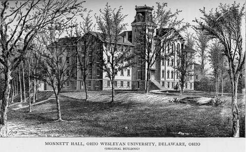
[3] Landmark name Image Date listed Location City or town Summary 1 Monnett Hall 
February 20, 1980 Ohio Wesleyan University campus at Elizabeth and Winter Sts.
40°18′3.6″N 83°4′35.6″W / 40.301°N 83.076556°WDelaware See also
References
- ^ The latitude and longitude information provided in this table was derived originally from the National Register Information System, which has been found to be fairly accurate for about 99% of listings. For about 1% of NRIS original coordinates, experience has shown that one or both coordinates are typos or otherwise extremely far off; some corrections may have been made. A more subtle problem causes many locations to be off by up to 150 yards, depending on location in the country: most NRIS coordinates were derived from tracing out latitude and longitudes off of USGS topographical quadrant maps created under North American Datum of 1927, which differs from the current, highly accurate GPS system used by Google maps. Chicago is about right, but NRIS longitudes in Washington are higher by about 4.5 seconds, and are lower by about 2.0 seconds in Maine. Latitudes differ by about 1.0 second in Florida. Some locations in this table may have been corrected to current GPS standards.
- ^ "National Register of Historic Places: Weekly List Actions". National Park Service, United States Department of the Interior. Retrieved on November 10, 2011.
- ^ a b Numbers represent an ordering by significant words. Various colorings, defined here, differentiate National Historic Landmark sites and National Register of Historic Places Districts from other NRHP buildings, structures, sites or objects.
- ^ "National Register Information System". National Register of Historic Places. National Park Service. . http://nrhp.focus.nps.gov/natreg/docs/All_Data.html.
- ^ Location derived from Squier, E.G., and E.H. Davis. Ancient Monuments of the Mississippi Valley. Washington: Smithsonian, 1848, page 36 and plate 14. The NRIS lists the site as "Address Restricted"
- ^ Location derived from the Google Maps placement of Highbanks Municipal Park on DeLorme. Ohio Atlas & Gazetteer. 7th ed. Yarmouth: DeLorme, 2004, 58. ISBN 0-89933-281-1. The NRIS lists the site as "Address Restricted".
- ^ Location derived from Mills, William C. Archeological Atlas of Ohio. Columbus: Ohio State Archeological and Historical Society, 1914, page 21 and plate 21. The NRIS lists the site as "Address Restricted".
- ^ Location derived from this EPA document and pages 13-14 of this Delaware State Park webpage; the NRIS lists the site as "Address Restricted"
Municipalities and communities of Delaware County, Ohio County seat: Delaware Cities Columbus‡ | Delaware | Dublin‡ | Powell | Westerville‡

Villages Ashley | Galena | Ostrander | Shawnee Hills | Sunbury
Townships Unincorporated
communitiesAfrica | Kilbourne | Lewis Center | Radnor
Ghost town Carpenter's Mill
Footnotes ‡This populated place also has portions in an adjacent county or counties
Categories:- National Register of Historic Places in Ohio by county
- Delaware County, Ohio
-


Wikimedia Foundation. 2010.