- Imperial County, California
-
Imperial County, California — County — The fields of Imperial Valley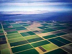

SealLocation in the state of California California's location in the United States
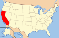
Country  United States
State  California
Region Imperial Valley Incorporated August 7, 1907 County seat El Centro Largest city El Centro Area – Total 4,481.73 sq mi (11,607.6 km2) – Land 4,174.73 sq mi (10,812.5 km2) – Water 307.00 sq mi (795.1 km2) Population (2010 Census) – Total 174,528 – Density 38.9/sq mi (15/km2) Time zone Pacific Standard Time (UTC-8) – Summer (DST) Pacific Daylight Time (UTC-7) Website www.imperialcounty.net Imperial County is a county located in the Imperial Valley, in the far southeast of the U.S. state of California, bordering both Arizona and Mexico. It is part of the El Centro Metropolitan Area, which encompasses all of Imperial County. The population as of 2000 was 142,361. The county seat is the city of El Centro. Established in 1907, it was the last county to be established in California. Imperial County is also part of the Southern California border region, also referred to as San Diego-Imperial, the smallest but most economically diverse region in the state.[1]
Although this region is a desert, with high temperatures and low average rainfall of three inches (seventy-five mm) per year, the economy is heavily based on agriculture due to irrigation, supplied wholly from the Colorado River via the All-American Canal.
The Imperial Valley is a melting pot of European American and Hispanic cultures. On the American side, the majority of residents are of Mexican American heritage, while the Mexican side was greatly influenced by American culture for many decades. The entire valley is a multi-racial mixture of European Americans, East Asian Americans, South Asian Americans, some African Americans and Native Americans.
Contents
History
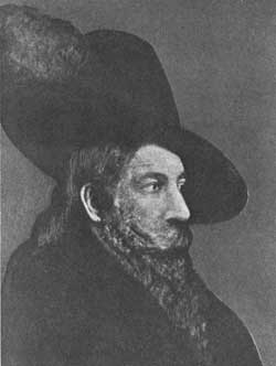
 Juan Bautista de Anza Bezerra Nieto
Spanish explorer Melchior Díaz was one of the first Europeans to visit the area around Imperial Valley in 1540. The explorer Juan Bautista de Anza also explored the area in 1776.[2] Years later, after the Mexican-American War, the northern half of the valley was annexed by the U.S., while the southern half remained under Mexican rule. Small scale settlement in natural aquifer areas occurred in the early 19th century (the present-day site of Mexicali), but most permanent settlement (Anglo Americans in the U.S. side, Mexicans in the other side) was after 1900.
In 1905, torrential rainfall in the American Southwest caused the Colorado River (the only drainage for the region) to flood, including canals that had been built to irrigate the Imperial Valley. Since the valley is partially below sea level, the waters never fully receded, but collected in the Salton Sink in what is now called the Salton Sea, the world's only artificial inland sea.
Imperial County was formed in 1907 from the eastern portion of San Diego County. The county took its name from Imperial Valley, itself named for the Imperial Land Company, a subsidiary of the California Development Company, which at the turn of the 20th century had claimed the southern portion of the Colorado desert for agriculture. Much of the Imperial Land Company's land also existed in Mexico (Baja California). The objective of the company was commercial crop farming development.
By 1910, the land company had managed to settle and develop thousands of farms on both sides of the border. But the Mexican Revolution severely disrupted the company's plans. Nearly 10,000 farmers and their families in Mexico were ethnically cleansed by the rival Mexican armies. Not until the 1920s was the other side of California in America sufficiently peaceful and prosperous for the company to earn a return for a large percentage of Mexicans, but some chose to stay and lay down roots in newly sprouted communities in the valley.
The county experienced a period of migration of "Okies" from drought-trodden dust bowl farms by the need of migrant labor, and prosperous job-seekers alike from across the U.S. arrived in the 1930s and 1940s, especially in World War II and after the completion of the All American Canal from its source, the Colorado River, from 1948 to 1951. By the 1950 census, over 50,000 residents lived in Imperial County alone, about 40 times that of 1910. Most of the population was year-round but would increase every winter by migrant laborers from Mexico. Until the 1960s, the farms in Imperial County provided substantial economic returns to the company and the valley.
In the 2000's, the real estate boom and bust impacted Imperial County. Currently, El Centro has one of the U.S' highest unemployment rates (above 30-34%) and ranks one of the state's poorest counties or have a lower than state and national average annual household income.
Sites of interest
Fort Yuma
Fort Yuma is located on the banks of the Colorado River in Winterhaven, California. First established after the end of the Mexican-American War in 1848, it was originally located in the bottoms near the Colorado River, less than 1-mile (1.6 km) below the mouth of the Gila River. It was to defend the newly settled community of Yuma, Arizona on the other side of the Colorado River and the nearby Mexican border. In March 1851 the post was moved to a small elevation on the Colorado's west bank, opposite the present city of Yuma, Arizona, on the site of the former Mission Puerto de Purísima Concepción. This site had been occupied by Camp Calhoun, named for John C. Calhoun, established in 1849. Fort Yuma was established to protect the southern emigrant travel route to California and to attempt control of the Yuma Indians in the surrounding 100-mile (160 km) area.[3]
Blue Angels
 Blue Angels
NAF El Centro is the winter home of the U.S. Navy Flight Demonstration Squadron, The Blue Angels. NAF El Centro historically kicks off the Blue Angels' season with their first air show, traditionally held in March.[4]
Imperial Valley Expo & fairgrounds
Home to the California Mid-Winter Fair and Fiesta which is the local county fair, held in late February and known throughout North America. It is also home to the Imperial Valley Speedway, a race track of 3⁄8 miles (600 m).[5]
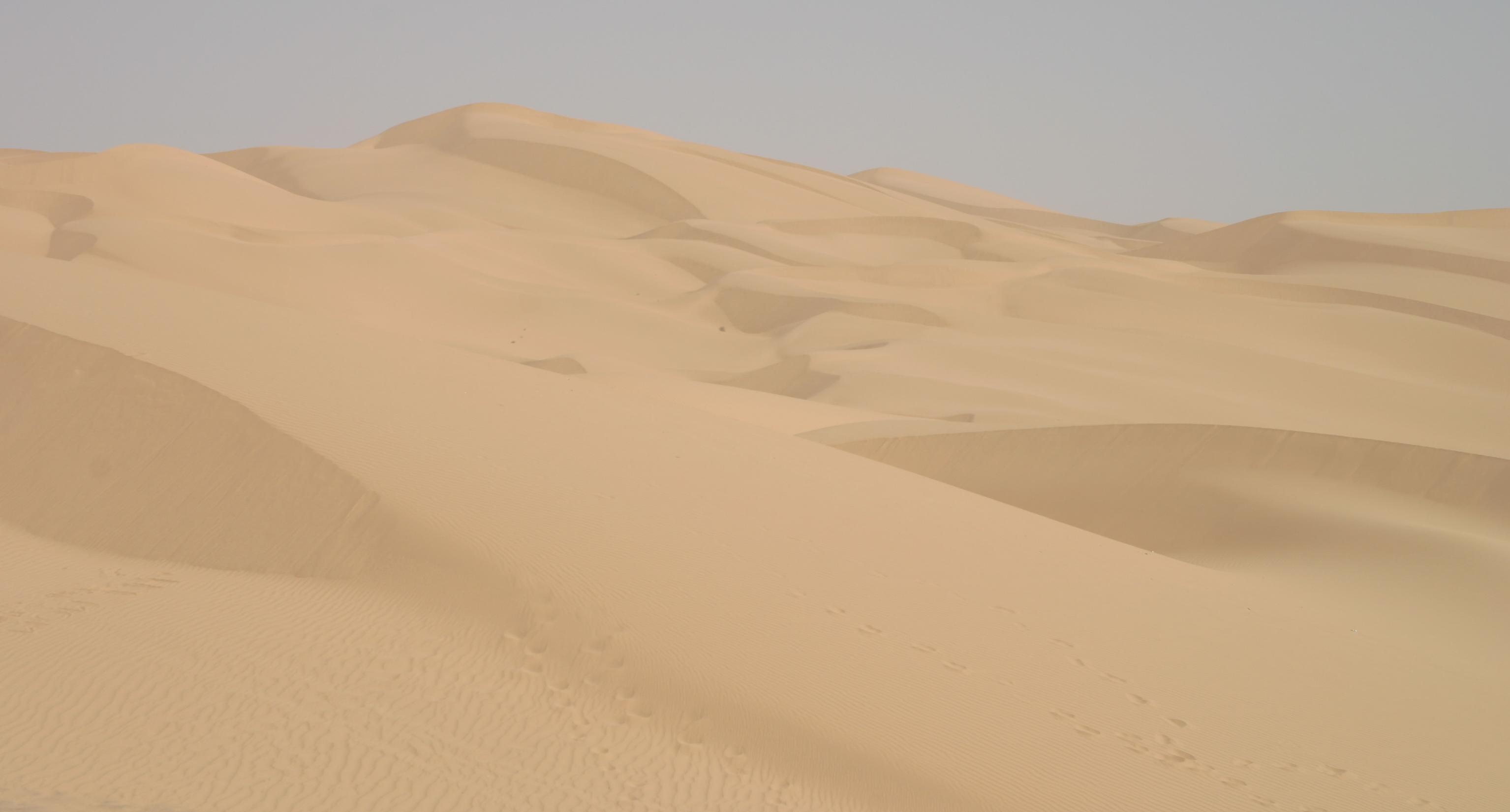
Algodones Sand Dunes
 The Algodones Dunes
The name Algodones Dunes refers to the entire geographic feature, while the administrative designation for that portion managed by the Bureau of Land Management is the "Imperial Sand Dunes Recreation Area" (sometimes called the "Glamis Dunes"). The Algodones Sand Dunes are the largest mass of sand dunes in California. This dune system extends for more than 40 miles (60 km) along the eastern edge of the Imperial Valley agricultural region in a band averaging 5 miles (8 km) in width. A major east-west route of the Union Pacific railroad skirts the eastern edge.The dune system is divided into 3 areas. The northern most area is known as Mammoth Wash. South of Mammoth Wash is the North Algodones Dunes Wilderness established by the 1994 California Desert Protection Act. This area is closed to motorized use and access is by hiking and horseback. The largest and most heavily used area begins at Highway 78 and continues south just past Interstate 8. The expansive dune formations offer picturesque scenery,, a chance to view rare plants and animals, and a playground for ATV and off-roading enthusiasts. The dunes are also popular in film making and have been the site for movies such as Star Wars Episode VI: Return of the Jedi.[6]
Colorado River
The Colorado River is a river in the southwestern United States and northwestern Mexico, approximately 2,330 kilometres (1,450 mi) long, draining a part of the arid regions on the western slope of the Rocky Mountains. The natural course of the river flows from north of Grand Lake, Colorado into the Gulf of California. For many months out of the year, however, no water actually flows from the United States to the gulf, due to human consumption. The river is a popular destination for water sports including fishing, boating, water-skiing, and jet-skiing.[7]
Salvation Mountain
 Welcome to Salvation Mountain
Salvation Mountain (location 33°15′14.9″N 115°28′21.4″W / 33.254139°N 115.472611°W) is a colorful artificial mountain north of Calipatria, California, near Slab City. It is made from adobe, straw, and thousands of gallons of paint. It was created by Leonard Knight to convey the message that "God Loves Everyone". Knight refused substantial donations of money and labor from supporters who wished to modify his message of universal love to favor or disfavor particular groups.
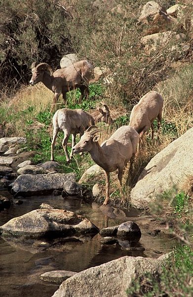
Anza-Borrego Desert State Park
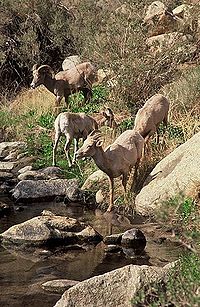 Bighorn Sheep at Palm Canyon in Anza-Borrego State Park
Anza-Borrego Desert State Park, portions of which are located in Imperial County, is the largest state park in California. 500 miles (800 km) of dirt roads, 12 wilderness areas and miles of hiking trails provide visitors with an unparalleled opportunity to experience the wonders of the Colorado Desert. The park is named after Spanish explorer Juan Bautista de Anza and the Spanish name borrego, or bighorn sheep. The park features washes, wildflowers, palm groves, cacti and sweeping vistas. Visitors may also have the chance to see roadrunner, golden eagles, kit foxes, mule deer and bighorn sheep as well as iguanas, chuckwallas and the red diamond rattlesnake.
Fossil Canyon and Painted Gorge
Located near Ocotillo, California in the Coyote Mountains, Fossil Canyon and the surrounding area is a great place for rock hounding and fossil hunting. The fossils here are not dinosaurs, but ancient shells, coral, and oysters from the Miocene epoch when the area was underwater.[8]
The Painted Gorge, located on the eastern side of the Coyote Mountains, consists of sedimentary, metamorphic and igneous rocks. Heat and movement over time has created fantastic shapes and colors. Oranges, reds, purples, and mauves mixed with browns and blacks create a palette of color as the sun illuminates and plays shadows upon this geologic wonder.[8]
Imperial NWR
 Mesquite point at Imperial NWR
The Imperial National Wildlife Refuge protects wildlife habitat along 30 miles (50 km) of the lower Colorado River in Arizona and California, including the last un-channeled section before the river enters Mexico. The river and its associated backwater lakes and wetlands are a green oasis, contrasting with the surrounding desert mountains. It is a refuge and breeding area for migratory birds and local desert wildlife.[9]
Sonny Bono Salton Sea NWR
The Sonny Bono Salton Sea National Wildlife Refuge is located 40 miles (60 km) north of the Mexican border at the southern end of the Salton Sea in California’s Imperial Valley. Situated along the Pacific Flyway, the refuge is the only one of its kind, located 227 feet below sea level. Because of its southern latitude, elevation and location in the Colorado Desert, the refuge experiences some of the highest temperatures in the nation. Daily temperatures from May to October generally exceed 100°F with temperatures of 116°-120°F recorded yearly.[10]
Mexicali
Mexico (the border city of Mexicali, Baja California) offers big city amenities like museums, a zoo, a sports convention center, and an international airport. Visitors cross by foot or car from Calexico in the United States every day. Restaurants and taco stands, pharmacies, bars and dance clubs are part of the draw for the city's tourists. Many shops and stalls selling Mexican crafts and souvenirs are also located in walking distance from the border. Also many residents from California, Arizona and Nevada look for medical and dental services in Mexicali, because they tend to be less expensive than those in the United States. Mexico's drinking age of 18 (vs. 21 in the United States) makes it a common weekend destination for many high school and college aged Southern Californians.
Geography
According to the 2000 census, the county has a total area of 4,481.73 square miles (11,607.6 km2), of which 4,174.73 square miles (10,812.5 km2) (or 93.15%) is land and 307.00 square miles (795.1 km2) (or 6.85%) is water.[11][12] Much of Imperial County is below sea level.
The county is in the Colorado Desert, an extension of the larger Sonoran Desert.
The Colorado River forms the county's eastern boundary. Two notable geographic features are found in the county, the Salton Sea, at 235 feet (72 m) below sea level, and the Algodones Dunes, one of the largest dune fields in America.[12]
The Chocolate Mountains are located east of the Salton Sea, and extend in a northwest-southeast direction [12] for approximately 60 miles (97 km).
In this region, the geology is dominated by the transition of the tectonic plate boundary from rift to fault. The southernmost strands of the San Andreas Fault connect the northern-most extensions of the East Pacific Rise. Consequently, the region is subject to earthquakes, and the crust is being stretched, resulting in a sinking of the terrain over time.
Cities
Towns over 5,000 population
Towns over 1,000 population
- Heber - 2,566
- Westmorland - 2,131
- Seeley - 1,624
- Niland - 1,143
- Salton City - 1,143
Towns under 1,000 population
- Desert Shores - 792
- Winterhaven - 529
- Salton Sea Beach - 392
- Bombay Beach - 366
- Ocotillo - 296
- Palo Verde - 236
- Bard, California - data not available
- Glamis, California - data not available
- Plaster City - data not available
Adjacent counties and municipios
- Riverside County, California, north
- Yuma County, Arizona, southeast
- La Paz County, Arizona, northeast
- San Diego County, California, west
- Mexicali, Baja California, Mexico - south
- Tecate, Baja California, Mexico - southwest
National protected areas
- Cibola National Wildlife Refuge (part)
- Imperial National Wildlife Refuge (part)
- Sonny Bono Salton Sea National Wildlife Refuge
Codes for Imperial
Area Codes
Main article: List of California area codes760 - Covers all of the El Centro metropolitan area as well as Palm Springs, Oceanside, Bishop, Ridgecrest, Barstow, Needles; northern San Diego County, and southeastern California, including much of the Mojave Desert and the Owens Valley. (Split from 619 on March 22, 1997, overlayed by area code 442 in 2009).
Zip Codes
- 92243 in El Centro, CA • 43,744
- 92231 in Calexico, CA • 27,792
- 92227 in Brawley, CA • 23,419
- 92251 in Imperial, CA • 14,469
- 92250 in Holtville, CA • 8,038
- 92233 in Calipatria, CA • 7,854
- 92283 in Winterhaven, CA • 3,622
- 92249 in Heber, CA • 3,558
- 92257 in Bombay Beach, CA • 2,710
- 92281 in Westmorland, CA • 2,362
- 92273 in Seeley, CA • 1,588
- 92275 in Salton City, CA • 803
- 92259 in Ocotillo, CA • 500
- 92266 in Palo Verde, CA • 340
Economy
Thousands of acres of prime farmland have transformed the desert into one of the most productive farming regions in California with an annual crop production of over $1 billion. Agriculture is the largest industry in Imperial County and accounts for 48% of all employment.[13] Although this region is a desert, with high temperatures and low average rainfall of three inches (seventy-five mm) per year, the economy is heavily based on agriculture due to irrigation, which is supplied wholly from the Colorado River via the All-American Canal. A vast system of canals, check dams, and pipelines carry the water all over the valley, a system which forms the Imperial Irrigation District, or IID. The water distribution system includes over 1,400 miles (2,300 km) of canal and with 1,100 miles (1,800 km) of pipeline. The number of canal and pipeline branches number roughly over a hundred. Imported water and a long growing season allow two crop cycles each year, and the Imperial Valley is a major source of winter fruits and vegetables, cotton, and grain for U.S. and international markets. Alfalfa is another major crop produced in the Imperial Valley. The agricultural lands are served by a constructed agricultural drain system, which conveys surface runoff and subsurface drainage from fields to the Salton Sea, which is a designated repository for agricultural runoff.[14]
El Centro is the commercial center of Imperial County. Fifty percent of the jobs in El Centro come from the service and retail sector.[13]
A recent growth in the interest of Imperial County as a filming location, has spurred growth in servicing this industry.[13] Because of the county's desert environment and proximity to Los Angeles, California, movies are sometimes filmed in the sand dunes outside the agricultural portions of the county. These have included Star Wars Episode VI: Return of the Jedi, Stargate, The Scorpion King, and Into the Wild. Additionally, portions of the 2005 film Jarhead were filmed here because of its similarity to the desert terrain of Iraq.[citation needed]
Renewable energy source
Imperial Valley has become a hotbed of renewable energy projects, both solar and geothermal.[15] This is driven in part by California's mandate to generate 20% of its power from renewable sources by the end of 2010, the valley's excellent sun resources, the high unemployment, its proximity to large population centers on the coast, and large tracts of otherwise unusable desert land.[15] Much of the land suitable for green energy is owned by the federal government (Bureau of Land Management). As of April 2008, the BLM has received 163 applications to build renewable energy projects on 1,600,000 acres (6,500 km2) in California, "almost all of them are planned for the Imperial Valley and the desert region north of the valley."[15] Stirling Energy is currently building one of the world's largest solar thermal plants, 10 square miles (26 km2) with 38,000 "sun catchers," it will power up to 600,000 homes once it is fully operational by around 2015.[15] CalEnergy currently runs a geothermal plant that generates enough power for 300,000 homes and could tap into more for up to 2.5 million homes.[15]
Transportation infrastructure
Major highways
 Interstate 8
 State Route 7
 State Route 78
 State Route 86
 State Route 98
 State Route 111
 State Route 115
Public transportation
Imperial County is served by Greyhound Lines and Imperial Valley Transit buses. Amtrak trains also travel through the county, but with no scheduled stops; the nearest stop is in Yuma, Arizona.
Airports
- Imperial County Airport, located just north of El Centro, is the main airport in the county. It is primarily a general aviation airport with limited commercial flight service.
- Holtville Airport is a general aviation airport located roughly 5 miles (8 km) east of Holtville.
- Calexico Airport is located 15 miles (24 km) south of Interstate 8 on State Route 111. It is a general aviation field, used in part to service maquiladora factories in nearby Mexicali.
Demographics
Historical populations Census Pop. %± 1910 13,591 — 1920 43,453 219.7% 1930 60,903 40.2% 1940 59,740 −1.9% 1950 62,975 5.4% 1960 72,105 14.5% 1970 74,492 3.3% 1980 92,110 23.7% 1990 109,303 18.7% 2000 142,361 30.2% 2010 174,528 22.6% [16][17][18] 2010
The 2010 United States Census reported that Imperial County had a population of 174,528. The racial makeup of Imperial County was 102,553 (58.8%) White, 5,773 (3.3%) African American, 3,059 (1.8%) Native American, 2,843 (1.6%) Asian, 165 (0.1%) Pacific Islander, 52,413 (30.0%) from other races, and 7,722 (4.4%) from two or more races. Hispanic or Latino of any race were 140,271 persons (80.4%).[19]
Population reported at 2010 United States Census The County Total
PopulationWhite African
AmericanNative
AmericanAsian Pacific
Islanderother
racestwo or
more racesHispanic
or Latino
(of any race)Imperial County 174,528 102,553 5,773 3,059 2,843 165 52,413 7,722 140,271 Incorporated
cityTotal
PopulationWhite African
AmericanNative
AmericanAsian Pacific
Islanderother
racestwo or
more racesHispanic
or Latino
(of any race)Brawley 24,953 13,570 510 241 349 32 9,258 993 20,344 Calexico 38,572 23,150 134 204 504 21 12,920 1,639 37,354 Calipatria 7,705 3,212 1,612 79 95 25 2,455 227 4,940 El Centro 42,598 25,376 1,081 554 965 34 12,356 2,232 34,751 Holtville 5,939 3,655 37 41 50 4 1,977 175 4,858 Imperial 14,758 9,298 331 154 370 13 3,783 809 11,046 Westmorland 2,225 1,038 21 38 11 0 1,042 75 1,938 Census-designated
placeTotal
PopulationWhite African
AmericanNative
AmericanAsian Pacific
Islanderother
racestwo or
more racesHispanic
or Latino
(of any race)Bombay Beach 295 223 37 8 1 0 22 4 59 Desert Shores 1,104 709 8 26 4 1 307 49 848 Heber 4,275 2,174 5 33 15 0 1,758 290 4,197 Niland 1,006 539 36 20 36 0 315 60 618 Ocotillo 266 242 1 1 2 0 17 3 61 Palo Verde 171 124 2 5 1 0 26 13 33 Salton City 3,763 2,260 80 61 61 5 1,159 137 2,368 Salton Sea Beach 422 309 6 4 2 2 82 17 229 Seeley 1,739 746 19 7 21 2 793 151 1,489 Winterhaven 394 245 4 37 1 0 84 23 261 Unincorporated
communitiesTotal
PopulationWhite African
AmericanNative
AmericanAsian Pacific
Islanderother
racestwo or
more racesHispanic
or Latino
(of any race)All others not CDPs (combined) 24,343 15,683 1,849 1,546 355 26 4,059 825 14,877 2009
According to the 2009 American Community Survey, Imperial County was 68.2% White (15.8% non-Hispanic White alone), 3.6% Black or African American, 1.5% American Indian and Alaska Native, 2.3% Asian, 0.1% Native Hawaiian and Other Pacific Islander, 21.9% from Some other race, and 2.9% from Two or more races. Hispanics and Latinos of any race made up 77.3% of the population. Mexican Americans made up 75.8% of Imperial County's population.[20]
The top five largest ancestry groups in Imperial County are the following[21]:
- Mexican: 75.8%
- German: 4.5%
- Irish: 4.1%
- African American: 3.6%
- English: 2.2%
2000
As of the census[22] of 2000, there were 142,361 people, 39,384 households, and 31,467 families residing in the county. The population density was 34 people per square mile (13/km²). There were 43,891 housing units at an average density of 10 per square mile (4/km²). The racial makeup of the county was 49.37% White, 3.95% Black or African American, 1.87% Native American, 1.99% Asian, 0.08% Pacific Islander, 39.08% from other races, and 3.65% from two or more races. 72.22% of the population were Hispanic or Latino of any race. 65.7% spoke Spanish as their first language and 32.3% English.
There were 39,384 households out of which 46.7% had children under the age of 18 living with them, 57.7% were married couples living together, 17.1% had a female householder with no husband present, and 20.1% were non-families. 17.1% of all households were made up of individuals and 8.1% had someone living alone who was 65 years of age or older. The average household size was 3.33 and the average family size was 3.77.
In the county the population was spread out with 31.4% under the age of 18, 9.9% from 18 to 24, 30.4% from 25 to 44, 18.2% from 45 to 64, and 10.0% who were 65 years of age or older. The median age was 31 years. For every 100 females there were 109.3 males. For every 100 females age 18 and over, there were 111.4 males.
The median income for a household in the county was $31,870, and the median income for a family was $35,226. Males had a median income of $32,775 versus $23,974 for females. The per capita income for the county was $13,239. About 19.4% of families and 22.6% of the population were below the poverty line, including 28.7% of those under age 18 and 13.6% of those age 65 or over.
Imperial County has the lowest per capita income of any county in Southern California and among the bottom five counties in the state.
By 2006 the population had risen to 160,201, the population growth rate since the year 2000 was 30%, the highest in California and fifth highest in the United States in the time period. High levels of immigration, new residents search for affordable homes, and a search for retirement homes can explain the population increase.
Politics
Imperial County vote
by party in presidential electionsYear GOP DEM Others 2008 36.1% 14,008 62.3% 24,162 2.4% 4,208 2004 46.4% 15,890 52.4% 17,964 1.2% 420 2000 43.3% 12,524 53.5% 15,489 3.2% 924 1996 36.8% 9,705 55.3% 14,591 8.0% 2,104 1992 38.6% 9,759 43.9% 11,109 17.6% 4,450 1988 55.2% 12,889 43.8% 10,243 1.0% 233 1984 62.0% 13,829 36.9% 8,237 1.1% 235 1980 55.9% 12,068 36.9% 7,961 7.2% 1,550 1976 49.9% 10,618 48.2% 10,244 1.9% 400 1972 62.1% 14,178 34.9% 7,982 3.0% 689 1968 52.9% 10,818 36.6% 7,481 10.5% 2,147 1964 48.1% 10,330 51.9% 11,143 0.1% 19 1960 53.6% 10,606 46.0% 9,119 0.4% 81 1956 56.1% 10,526 43.7% 8,197 0.3% 58 1952 62.1% 11,044 37.2% 6,619 0.6% 112 1948 52.6% 6,217 44.9% 5,301 2.5% 292 1944 53.8% 5,979 45.8% 5,085 0.4% 48 1940 46.6% 6,854 52.5% 7,728 0.9% 130 1936 38.3% 4,771 60.8% 7,560 0.9% 113 1932 29.0% 3,783 67.3% 8,772 3.7% 484 1928 67.6% 5,417 31.0% 2,486 1.4% 109 1924 50.3% 3,455 11.0% 759 38.7% 2,658 1920 64.5% 4,699 27.8% 2,022 7.7% 563 Imperial County is a Democratic stronghold in presidential, congressional and local elections. The last Republican to win a majority in the county was George H. W. Bush in 1988.
On November 4, 2008, Imperial County voted 69.7% for Proposition 8, which amended the California Constitution to ban same-sex marriages, showing more support for the proposition than any other strongly Democratic county.[23][24] After being declared unconstitutional by a lower federal court, Imperial County continues to defend Proposition 8 in the federal judicial system.[25]
Imperial is part of California's 51st congressional district, which is held by Democrat Bob Filner. In the state legislature, Imperial is part of the 80th Assembly district, which is held by Democrat Manuel Perez, and the 40th Senate district, which is held by Democrat Juan Vargas.
In popular culture
- Dimmsdale is a fictional city located in Imperial County that is shown on the Nickelodeon animated series The Fairly OddParents.
- Scenes for the 2006 film Borat: Cultural Learnings of America for Make Benefit Glorious Nation of Kazakhstan were filmed in Imperial County, but were not used in the finished film.
- The majority of Jarhead and the Salton Sea was filmed in the Imperial Valley.
- Scenes from Star Wars were filmed in the Imperial Valley sand dunes, Top Gun were also filmed in the El Centro Naval Air Station and Independence Day was located in the Imperial Valley.
- Rock en Espanol group Calexico glean their name from the Imperial Valley border town that adjoins Mexicali, Baja California of Mexico.
- Imperial, by William T. Vollmann, published July 30, 2009, documents the history and culture of Imperial County, California. A companion volume of photographs was published August 18, 2009.
See also
- El Centro Metropolitan Area
- Category: Geography of Imperial County, California
- National Register of Historic Places listings in Imperial County, California
- Southern Border region of California
References
- ^ Source California.gov
- ^ "De Anza Trail". http://www.solideas.com/DeAnza/TrailGuide/Imperial/index.html. Retrieved 2009-08-03.
- ^ "Fort Yuma". http://www.militarymuseum.org/FtYuma.html. Retrieved 2009-08-05.
- ^ "Blue Angels Official Website". http://www.blueangels.navy.mil/index.htm. Retrieved 2009-08-05.
- ^ "Imperial Valley Expo". http://www.ivexpo.com/geninfo.htm. Retrieved 2009-08-05.
- ^ "Algodones Sand Dunes". http://www.desertusa.com/sandhills/sandhills.html. Retrieved 2009-08-05.
- ^ "Things to Do in Yuma". http://www.visityuma.com/things.html. Retrieved 2009-08-05.[dead link]
- ^ a b "Fossil Canyon and Painted Gorge". http://www.desertusa.com/magoct97/oct_painted.html. Retrieved 2009-08-05.
- ^ "Imperial NWR". http://www.fws.gov/southwest/refuges/arizona/imperial.html. Retrieved 2009-08-04.[dead link]
- ^ "Sonny Bono Salton Sea National Wildlife Refuge". http://www.fws.gov/saltonsea/. Retrieved 2009-08-04.
- ^ "Census 2000 U.S. Gazetteer Files: Counties". United States Census. http://www.census.gov/tiger/tms/gazetteer/county2k.txt. Retrieved 2011-02-13.
- ^ a b c "Imperial County". http://citybloc.com/California/Imperial%20County. Retrieved 2009-08-03.
- ^ a b c "El Centro Chamber of Commerce". http://www.elcentrochamber.org/the-city-of-el-centro/community/. Retrieved 2009-08-03.
- ^ "IID". http://www.iid.com/index.php. Retrieved 2009-08-03.[dead link]
- ^ a b c d e "Calif. Desert Becomes Home For Renewable Energy", Rob Schmitz, Morning Edition, April 3, 2009, NPR
- ^ http://www.census.gov/population/www/censusdata/cencounts/files/ca190090.txt
- ^ http://factfinder2.census.gov
- ^ http://mapserver.lib.virginia.edu/
- ^ "2010 Census P.L. 94-171 Summary File Data". United States Census Bureau. http://www2.census.gov/census_2010/01-Redistricting_File--PL_94-171/California/.
- ^ http://factfinder.census.gov/servlet/ADPTable?_bm=y&-geo_id=05000US06025&-qr_name=ACS_2009_1YR_G00_DP5&-context=adp&-ds_name=&-tree_id=309&-_lang=en&-redoLog=false&-format=
- ^ http://factfinder.census.gov/servlet/ADPTable?_bm=y&-context=adp&-ds_name=ACS_2009_1YR_G00_&-tree_id=309&-redoLog=true&-_caller=geoselect&-geo_id=05000US06025&-format=&-_lang=en
- ^ "American FactFinder". United States Census Bureau. http://factfinder.census.gov. Retrieved 2008-01-31.
- ^ "Proposition 8 Map - November 4, 2008, General Election - California Secretary of State:". http://www.sos.ca.gov/elections/sov/2008_general/maps/returns/props/prop-8.htm. Retrieved 2009-08-17.
- ^ "Registration by County". http://www.sos.ca.gov/elections/ror/ror-pages/15day-stwdsp-09/county.xls. Retrieved 2009-08-17.
- ^ Fagan, Kevin (2010-08-26). "Imperial County steps up to defend Prop. 8". The San Francisco Chronicle. http://www.sfgate.com/cgi-bin/article.cgi?f=/c/a/2010/08/22/MNTK1F0U3N.DTL.
External links
- Official Imperial County website
- Website for the City of Imperial, California
- Imperial Irrigation District
- Imperial Valley Economic Development Corporation
- Imperial Valley Living
- Statistical profile of Imperial County, California

Riverside County La Paz County, Arizona San Diego County 
 Imperial County, California

Tecate, Baja California, Mexico Mexicali, Baja California, Mexico Yuma County, Arizona Municipalities and communities of Imperial County, California Cities Brawley | Calexico | Calipatria | El Centro | Holtville | Imperial | Westmorland
CDPs Bombay Beach | Desert Shores | Heber | Niland | Ocotillo | Palo Verde | Salton City | Salton Sea Beach | Seeley | Winterhaven
Unincorporated
communitiesAcolita | Alamorio | Amos | Andrade | Anza | Araz Junction | Bard | Bertram | Bonds Corner | Boulder Park | Cactus | Citrus View | Clyde | Coolidge Springs | Coyote Wells | Curlew | Date City | Dixieland | Dunes | Edgar | Elmore Desert Ranch | Estelle | Felicity | Fondo | Frink | Fuller | Glamis | Gordons Well | Hovley | Imperial Gables | Iris | Kane Spring | Meloland | Mesquite | Moss | Mount Signal | Mundo | Munyon | Obregon | Ogilby | Orita | Paymaster Landing | Perrys Corner | Picacho | Plaster City | Pope | Rico | Rockwood | Ross Corner | Ruthven | Sandia | Slab City | Tortuga | Truckhaven | Verdant | Watermans Corner | Wiest | Wilsie | Wister
Indian
reservationsFort Yuma Indian Reservation | Torres-Martinez Indian Reservation
Ghost towns Araz | Barnes | Bernice | Bradtmoore | Butlers | Colorado | Concepcíon | Eastside | Gleason | Hazelwood | Highline | Indian Wells | Keystone | Laguna | Laparra | Lano | Mayflower | Mobile | No Mirage | Paringa | Picacho Basin | Potholes | Sackett's Wells | Sellew | Shamrock | Silsbee | Squeaky Springs
Southern Border Region Counties San Diego • Imperial
Global City
1.2 millionMajor Cities
100k-200kCities and towns
25k-100kEl Cajon • El Centro • Encinitas • Calexico • Fallbrook • Imperial Beach • La Mesa • La Presa • National City • Poway • San Marcos • Santee • Spring Valley • VistaCities and towns
under 25kAlpine • Bombay Beach • Bonita • Bostonia • Brawley • Casa de Oro-Mount Helix • Calipatria • Coronado • Desert Shores • Heber • Holtville • Imperial • Lakeside • Lemon Grove • Niland • Ocotillo • Palo Verde • Ramona • Rancho San Diego • Salton City • Salton Sea Beach • Seeley • Solana Beach • Westmorland • Winter Gardens • WinterhavenBodies of water Alamo River • Colorado River • Mission Bay • New River • Salton Sea • San Diego Bay • San Diego River • San Luis Rey River • Santa Margarita River • Sweetwater River • Tijuana RiverLandforms Regions North County • Borrego • South Bay • East County • San Diego • Imperial Valley • Southern Border RegionCategories:- California counties
- Imperial County, California
- Imperial Valley
- Geography of Imperial County, California
- Counties of the United States with Hispanic majority populations


Wikimedia Foundation. 2010.